Old Maps of Warden Hutterite Colony, Washington for Academic Research
Study the evolution of Warden Hutterite Colony with 7 high-resolution historic maps. Whether you're teaching, researching, or modeling changes in land use, these maps provide essential visual documentation of urban, environmental, and geographic change.
- Analyze long-term change: Track patterns in development, transportation, and natural features.
- Ideal for environmental or urban studies: Support academic projects with primary historical map data.
- Use in the classroom or lab: Educators and researchers rely on these maps to bring historical context to life.
These maps are a powerful tool for teaching, research, and visualizing how Warden Hutterite Colony has changed over the decades.
Warden Hutterite Colony, WA maps
(7)- 1925 Map of Schrag
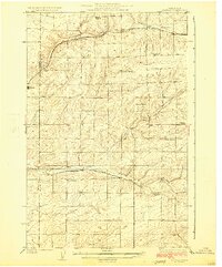 1925 Schrag1925 Print · USGSAdams County’s high desert plateau comes alive in the mid-twenties, showing a landscape of scattered grain elevators and family-named landmarks. Trace early rail life through Batum and Schrag, or locate rural schoolhouses like High Valley School and the Janke School.2 unique versions available
 - 1953 Map of Ritzville, 1966 Print
 1953 Ritzville1966 Print · USGSEastern Washington was undergoing a massive agricultural and industrial transformation in the mid-fifties as irrigation from the Grand Coulee Dam reached the plateau. Researchers can trace the mid-century rail network of the Great Northern and locate vital local sites like Larson Air Force Base and Odessa.3 unique versions available
 - 1959 Map of Ritzville
 1959 Ritzville1959 Print · USGSEastern Washington in the late fifties reveals a landscape transformed by massive irrigation projects and postwar growth. Genealogists and historians can trace rail-line communities from Ritzville to Davenport and locate landmarks like Larson Air Force Base and Telford Station.
 - 1965 Map of Ritzville
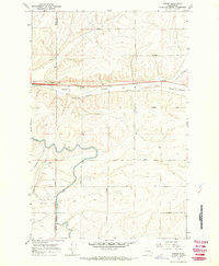
 1965 Ritzville1965 Print · USGSCentral Washington during the mid-sixties shows a landscape shaped by massive irrigation projects and the Cold War. Genealogists and historians can trace rail-town life and military presence through Ephrata Air Base, the Telford Station, and local schools.
 - 1967 Map of Weber, 1970 Print
 1967 Weber1970 Print · USGSLate 1960s Adams County comes into focus as the irrigation of the Columbia Basin transforms the dry coulees. Researchers can trace family-named routes like Urquhart Road, the rail siding at Schaeffer Spur, and the path of the East Low Canal.2 unique versions available
 - 1982 Map of Ritzville, 1983 Print
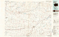 1982 Ritzville1983 Print · USGSEastern Washington's scabland landscape is captured here in the early eighties as a network of rail-towns and coulees. Researchers can trace the BURLINGTON NORTHERN route through Odessa, Lamona, and Ritzville or locate landmarks like Sprague Lake and Karakul Hills.
 - 2023 Map of Weber, 2023 Print
 2023 Weber2023 Print · USGSCentral Washington's agricultural heartland is documented here in the early 2020s, centered on the Weber settlement. Trace the intersection of natural features like Farrier Coulee with man-made infrastructure such as the East Low Canal.
End of results
Showing maps 1-7 of 7
Top cities near Warden Hutterite Colony
Frequently asked questions
- What are the different types of historical maps available for Warden Hutterite Colony?
- What is the oldest map of Warden Hutterite Colony?
- Where can I purchase historical maps of Warden Hutterite Colony for my home or office?
- Where can I download high-res historical maps of Warden Hutterite Colony?
- Are there historical topographic maps available for Warden Hutterite Colony?
- Is there historical aerial imagery available for Warden Hutterite Colony?
- Where are historical maps of Warden Hutterite Colony sourced from?