1950s Maps of Chelan County, Washington
Explore 6 historic maps of Chelan County from the 1950s. These maps offer a rare glimpse into what life looked like during the 1950s — showing old roads, neighborhoods, homes, and landmarks that have changed or disappeared over time.
Whether you're researching your family's past, planning a metal detecting trip, or studying how Chelan County's landscape evolved across the 1950s, these high-resolution maps are a powerful tool for exploring the history of this region.
- Focus on a specific era: All maps on this page are from the 1950s, giving you a focused view of this time period.
- See what’s changed: Compare century-old streets, trails, and buildings to today's modern landscape using overlays and satellite layers.
- Research with precision: Use these maps for genealogy, historical research, land use analysis, or educational projects.
- View, download, or print: Maps are fully viewable online in high resolution, and can be downloaded or printed for your own records.
Start exploring Chelan County's history through authentic maps from the 1950s. This is your window into the past.
Chelan County, WA maps
(6)- 1950 Map of Glacier Peak, 1954 Print
 1950 Glacier Peak1954 Print · USGSThe high cascades of Snohomish and Chelan counties are captured here in the mid-twentieth century, centered on the ice-clad summit of Glacier Peak. Trace the paths of early mountaineers and rangers through Lyman Camp, Mackinaw Shelter, and along the Pacific Crest Trail.4 unique versions available
 - 1953 Map of Ritzville, 1966 Print
 1953 Ritzville1966 Print · USGSEastern Washington was undergoing a massive agricultural and industrial transformation in the mid-fifties as irrigation from the Grand Coulee Dam reached the plateau. Researchers can trace the mid-century rail network of the Great Northern and locate vital local sites like Larson Air Force Base and Odessa.3 unique versions available
 - 1955 Map of Concrete, 1967 Print
 1955 Concrete1967 Print · USGSThe North Cascades in the mid-fifties reveal a landscape of deep glacier-fed lakes and riverside timber towns. You can trace the Great Northern rail lines through Granite Falls or locate remote outposts like Stehekin and Marblemount along the Skagit and Chelan waters.
 - 1957 Map of Wenatchee, 1973 Print
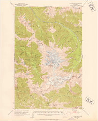
 1957 Wenatchee1973 Print · USGSThe northern Cascades and Columbia River valley appear here in the mid-fifties, showing the region's critical rail and transit corridors. Researchers can trace the routes of the Great Northern RR and Milwaukee Road through settlements like Skykomish, Baring, and Dryden.2 unique versions available
 - 1958 Map of Concrete
 1958 Concrete1958 Print · USGSThe North Cascades and Skagit Valley are captured here in the late fifties, showing a landscape defined by glacier-carved peaks and river-bottom settlements. Genealogists and historians can locate remote mining sites like Holden Mine and mountain outposts such as Stehekin, Marblemount, and Mazama.2 unique versions available
 - 1959 Map of Ritzville
 1959 Ritzville1959 Print · USGSEastern Washington in the late fifties reveals a landscape transformed by massive irrigation projects and postwar growth. Genealogists and historians can trace rail-line communities from Ritzville to Davenport and locate landmarks like Larson Air Force Base and Telford Station.
End of results
Showing maps 1-6 of 6
Top cities of Chelan County
- Wenatchee historical maps
- Chelan historical maps
- Cashmere historical maps
- Leavenworth historical maps
- Entiat historical maps
Frequently asked questions
- What are the different types of historical maps available for Chelan County?
- What is the oldest map of Chelan County?
- Where can I purchase historical maps of Chelan County for my home or office?
- Where can I download high-res historical maps of Chelan County?
- Are there historical topographic maps available for Chelan County?
- Is there historical aerial imagery available for Chelan County?
- Where are historical maps of Chelan County sourced from?