Old Maps of Stehekin, Washington for Genealogy
Trace your family roots with 7 historic maps of Stehekin. These high-res maps reveal old neighborhoods, homesites, landmarks, and streets — helping you uncover where your ancestors lived and how the area evolved over time.
- Explore historic neighborhoods: Identify where your relatives may have lived in the 1800s or 1900s.
- Compare maps over time: Trace the changes in streets, buildings, and landmarks for multi-generational research.
- Perfect for genealogy & ancestry research: Used by family historians and researchers to map out lineage and migration.
These maps are an incredible resource for exploring your personal connection to Stehekin's past.
Stehekin, WA maps
(7)- 1902 Map of Stehekin, 1955 Print
 1902 Stehekin1955 Print · USGSLake Chelan and the North Cascades are captured here at the dawn of the twentieth century, during a period of remote mountain development. Genealogists and historians can trace early settlements at Stehekin, Lucerne, and Gilbert, along with the route of the Holden Railroad.2 unique versions available
 - 1904 Map of Stehekin
 1904 Stehekin1904 Print · USGSThe northern reaches of Lake Chelan are captured here at the turn of the century, showing a wilderness being shaped by early mountain outposts and mining. Genealogists and researchers can trace remote sites like Gilbert and Holden, or the unique path of the Holden Railroad.5 unique versions available
 - 1955 Map of Concrete, 1967 Print
 1955 Concrete1967 Print · USGSThe North Cascades in the mid-fifties reveal a landscape of deep glacier-fed lakes and riverside timber towns. You can trace the Great Northern rail lines through Granite Falls or locate remote outposts like Stehekin and Marblemount along the Skagit and Chelan waters.
 - 1958 Map of Concrete
 1958 Concrete1958 Print · USGSThe North Cascades and Skagit Valley are captured here in the late fifties, showing a landscape defined by glacier-carved peaks and river-bottom settlements. Genealogists and historians can locate remote mining sites like Holden Mine and mountain outposts such as Stehekin, Marblemount, and Mazama.2 unique versions available
 - 1962 Map of Concrete
 1962 Concrete1962 Print · USGSThe Northern Cascades in the early sixties reveal a landscape of high alpine peaks and deep river valleys before the modern park era. Genealogists and historians can trace rail-and-river towns like Concrete, Darrington, and Stehekin, alongside industry at the Holden Mine.
 - 1969 Map of Stehekin, 1973 Print
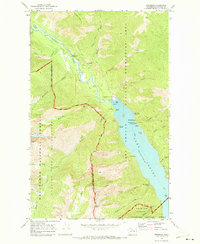 1969 Stehekin1973 Print · USGSStehekin and the northern reaches of Lake Chelan are captured in the late sixties, showing a wilderness outpost defined by its river and ferry connections. Researchers can trace the layout of Stehekin River settlements, the Stehekin PO, and local landmarks like Rainbow Falls.3 unique versions available
 - 2023 Map of Stehekin, 2023 Print
 2023 Stehekin2023 Print · USGSUpper Lake Chelan remains a world of water and wilderness in this recent survey of the Stehekin valley. Hikers and historians can trace the Lake Chelan Ferry route to Stehekin, finding waypoints like Buckner Orchard Trl and Rainbow Falls.
End of results
Showing maps 1-7 of 7
Frequently asked questions
- What are the different types of historical maps available for Stehekin?
- What is the oldest map of Stehekin?
- Where can I purchase historical maps of Stehekin for my home or office?
- Where can I download high-res historical maps of Stehekin?
- Are there historical topographic maps available for Stehekin?
- Is there historical aerial imagery available for Stehekin?
- Where are historical maps of Stehekin sourced from?