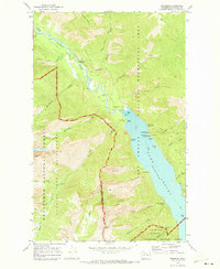
1969 Map of Stehekin
USGS Topo · Published 1973About this map
Lake Chelan anchors this 1969 survey, where the Stehekin River flows into the lake's northern tip amidst the high peaks of the Wenatchee National Forest. This remote outpost, accessible primarily by water, is centered around the Stehekin PO and the Purple Point Ranger Station. The map illustrates a landscape shaped by wilderness recreation and early utility infrastructure, including the Powerhouse on Powerhouse Creek and the Landing Strip near the riverbanks. Natural landmarks like the dramatic Rainbow Falls and Bridal Veil Falls are documented alongside established recreational sites such as Purple Point Campground and the Company Creek Campground. Significant elevation markers include Tupshin Peak and Rainbow Mountain, while a solitary Grave noted near the Gaging Station offers a poignant detail for local historians.
Find a feature on this map
47 named features on this map. Tap any name to fly to it.
Don’t see what you’re looking for? This feature index may not catch every label — zoom into the map to look around manually.
Map Details
Editions of this 1969 Stehekin Map
3 editions found
Other maps of this area

1902 · Stehekin
USGS Topo · 1:125,000

1904 · Stehekin
USGS Topo · 1:125,000

1944 · Holden
USGS Topo · 1:62,500

1944 · Lucerne
USGS Topo · 1:62,500

1949 · Lucerne
USGS Topo · 1:62,500

1949 · Holden
USGS Topo · 1:62,500

1955 · Concrete
USGS Topo · 1:250,000

1958 · Concrete
USGS Topo · 1:250,000

1962 · Concrete
USGS Topo · 1:250,000

1963 · Mc Gregor Mtn
USGS Topo · 1:24,000