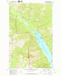
1969 Map of Stehekin
USGS Topo · Published 1980About this map
Stehekin serves as the isolated hub of activity on this 1969 survey, situated where the Stehekin River empties into the northern reaches of Lake Chelan. The map documents a landscape defined by seasonal recreation and deep wilderness management, featuring essential infrastructure like the Ranger Station, a Powerhouse, and a remote Landing Strip near Mcgregor Meadows. A lone Grave marked near a Gaging Station offers a quiet hint of the area's early human history. The terrain is dramatically vertical, punctuated by the massive Rainbow Falls and Bridal Veil Falls, with access limited to a network of Pack Trails. This study captures the area just as the Lake Chelan National Recreation Area and Glacier Peak Wilderness were being formalized, preserving the primitive character of these mountain outposts before modern expansion.
Find a feature on this map
53 named features on this map. Tap any name to fly to it.
Don’t see what you’re looking for? This feature index may not catch every label — zoom into the map to look around manually.
Map Details
Editions of this 1969 Stehekin Map
3 editions found
Other maps of this area

1902 · Stehekin
USGS Topo · 1:125,000

1904 · Stehekin
USGS Topo · 1:125,000

1944 · Holden
USGS Topo · 1:62,500

1944 · Lucerne
USGS Topo · 1:62,500

1949 · Lucerne
USGS Topo · 1:62,500

1949 · Holden
USGS Topo · 1:62,500

1955 · Concrete
USGS Topo · 1:250,000

1958 · Concrete
USGS Topo · 1:250,000

1962 · Concrete
USGS Topo · 1:250,000

1963 · Mc Gregor Mtn
USGS Topo · 1:24,000