Old Maps of Kewa, Washington for Academic Research
Study the evolution of Kewa with 8 high-resolution historic maps. Whether you're teaching, researching, or modeling changes in land use, these maps provide essential visual documentation of urban, environmental, and geographic change.
- Analyze long-term change: Track patterns in development, transportation, and natural features.
- Ideal for environmental or urban studies: Support academic projects with primary historical map data.
- Use in the classroom or lab: Educators and researchers rely on these maps to bring historical context to life.
These maps are a powerful tool for teaching, research, and visualizing how Kewa has changed over the decades.
Kewa, WA maps
(8)- 1948 Map of Wilmont Creek, 1964 Print
 1948 Wilmont Creek1964 Print · USGSThe northern reaches of the Columbia River are captured here in the late 1940s, showing the early years of the massive reservoir. Genealogists and local historians can trace small communities like Kewa and Rogers Bar, noting the exact locations of the Kewa Cem and rural schools.
 - 1950 Map of Wilmont Creek
 1950 Wilmont Creek1950 Print · USGSThe Colville and Spokane Indian Reservations meet here at the newly formed Lake Roosevelt in the years following the Grand Coulee Dam project. Genealogists and historians can locate old landmarks like Kewa, the Kewa Cem, and the Rogers Bar Sch.2 unique versions available
 - 1954 Map of Okanogan, 1964 Print
 1954 Okanogan1964 Print · USGSNorth Central Washington’s interior comes into focus during the mid-fifties, showing the rise of the Columbia River reservoir system. Genealogists and historians can trace the Great Northern rail line and locate historical mining operations at the Mountain Lion Mine or Gold Hill Mine.2 unique versions available
 - 1956 Map of Wilmont Creek, 1972 Print
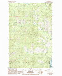
 1956 Wilmont Creek1972 Print · USGSThe settlement at Wilson Creek and its surrounding Grant County Coulee country are shown here in the mid-1950s. Trace the rail-and-water economy through the Great Northern line, local cemeteries, and the irrigation network around Soda Lake.
 - 1958 Map of Okanogan
 1958 Okanogan1958 Print · USGSThe Okanogan River valley and the Colville Indian Reservation are shown here in the late fifties, during a period of established river and rail commerce. Researchers can trace the Great Northern line through Oroville or locate landmarks like the Knowlton School and Orient Ranger Station.
 - 1984 Map of Nespelem
 1984 Nespelem1984 Print · USGSThe Colville Indian Reservation and the Columbia River valley are shown here in the mid-1980s, just as modern recreation was shaping the landscape. Genealogists and researchers can locate old communities like Inchelium and Keller or trace mining history at the Germania Mine.
 - 1985 Map of Kewa
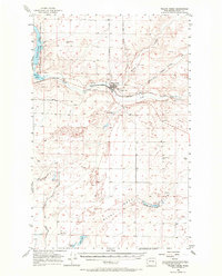
 1985 Kewa1985 Print · USGSIn the mid-eighties, the rugged interior of the Colville Indian Reservation overlooks the Columbia River. Local researchers can trace family roots at Kewa Cem or locate mineral prospects near Middle Mountain and Fish Lake.2 unique versions available
 - 2023 Map of Kewa, 2023 Print
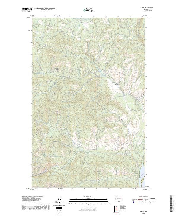 2023 Kewa2023 Print · USGSFerry County’s rugged interior is documented here in the early twenty-first century, showing the mountain terrain surrounding the Colville Indian Reservation. Researchers can locate remote landmarks like Kewa, the Kewa Cem, and the high reaches of Longhairs Pasture.
End of results
Showing maps 1-8 of 8
Frequently asked questions
- What are the different types of historical maps available for Kewa?
- What is the oldest map of Kewa?
- Where can I purchase historical maps of Kewa for my home or office?
- Where can I download high-res historical maps of Kewa?
- Are there historical topographic maps available for Kewa?
- Is there historical aerial imagery available for Kewa?
- Where are historical maps of Kewa sourced from?