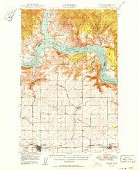
1956 Map of Wilmont Creek
USGS Topo · Published 1972About this map
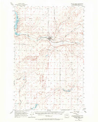
Wilson Creek sits at the heart of this mid-century landscape, positioned where the Great Northern railroad tracks parallel the winding course of Crab Creek. The map documents a complex irrigation and water management system in the arid terrain of Washington-Grant County, featuring a network of siphons, levees, and spoil banks that connect varied water bodies including Billy Clapp Lake and Soda Lake. The Great Northern rail line serves as a central artery for the region, supporting local infrastructure such as the town's water tank and a nearby landing field.
Find a feature on this map
20 named features on this map. Tap any name to fly to it.
Don’t see what you’re looking for? This feature index may not catch every label — zoom into the map to look around manually.
Map Details
Editions of this 1956 Wilmont Creek Map
This is the sole edition of this map. No revisions or reprints were ever made.
Other maps of this area

1948 · Hunters
USGS Topo · 1:62,500
1948 · Wilbur
USGS Topo · 1:62,500

1948 · Wilmont Creek
USGS Topo · 1:62,500
1948 · Lincoln
USGS Topo · 1:62,500

1948 · Turtle Lake
USGS Topo · 1:62,500

1950 · Lincoln
USGS Topo · 1:62,500
1950 · Turtle Lake
USGS Topo · 1:62,500

1950 · Wilmont Creek
USGS Topo · 1:62,500
1950 · Wilbur
USGS Topo · 1:62,500
1950 · Hunters
USGS Topo · 1:62,500