1920s Maps of Grays Harbor County, Washington
Explore 2 historic maps of Grays Harbor County from the 1920s. These maps offer a rare glimpse into what life looked like during the 1920s — showing old roads, neighborhoods, homes, and landmarks that have changed or disappeared over time.
Whether you're researching your family's past, planning a metal detecting trip, or studying how Grays Harbor County's landscape evolved across the 1920s, these high-resolution maps are a powerful tool for exploring the history of this region.
- Focus on a specific era: All maps on this page are from the 1920s, giving you a focused view of this time period.
- See what’s changed: Compare century-old streets, trails, and buildings to today's modern landscape using overlays and satellite layers.
- Research with precision: Use these maps for genealogy, historical research, land use analysis, or educational projects.
- View, download, or print: Maps are fully viewable online in high resolution, and can be downloaded or printed for your own records.
Start exploring Grays Harbor County's history through authentic maps from the 1920s. This is your window into the past.
Grays Harbor County, WA maps
(2)- 1921 Map of Quinault Lake
 1921 Quinault Lake1921 Print · USGSThe western Olympic Peninsula comes into focus in the early 1920s as forestry and local travel began to reshape the river valleys. Researchers can trace the path of the Olympic Highway through the Quinault Indian Reservation past landmarks like Chow Chow Prairie and Lone Mt.
 - 1921 Map of Satsop
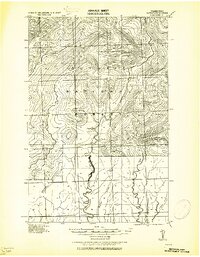 1921 Satsop1921 Print · USGSThe Olympic wilderness and early timber frontiers are documented here in the early twenties as logging infrastructure moved into the river valleys. Researchers can trace the Simpson Logging R.R. and locate the original Wynoochee RS station.
End of results
Showing maps 1-2 of 2
Top cities of Grays Harbor County
- Aberdeen historical maps
- Hoquiam historical maps
- Ocean Shores historical maps
- Montesano historical maps
- Elma historical maps
- Westport historical maps
See more
Frequently asked questions
- What are the different types of historical maps available for Grays Harbor County?
- What is the oldest map of Grays Harbor County?
- Where can I purchase historical maps of Grays Harbor County for my home or office?
- Where can I download high-res historical maps of Grays Harbor County?
- Are there historical topographic maps available for Grays Harbor County?
- Is there historical aerial imagery available for Grays Harbor County?
- Where are historical maps of Grays Harbor County sourced from?