1980s Maps of Grays Harbor County, Washington
Explore 24 historic maps of Grays Harbor County from the 1980s. These maps offer a rare glimpse into what life looked like during the 1980s — showing old roads, neighborhoods, homes, and landmarks that have changed or disappeared over time.
Whether you're researching your family's past, planning a metal detecting trip, or studying how Grays Harbor County's landscape evolved across the 1980s, these high-resolution maps are a powerful tool for exploring the history of this region.
- Focus on a specific era: All maps on this page are from the 1980s, giving you a focused view of this time period.
- See what’s changed: Compare century-old streets, trails, and buildings to today's modern landscape using overlays and satellite layers.
- Research with precision: Use these maps for genealogy, historical research, land use analysis, or educational projects.
- View, download, or print: Maps are fully viewable online in high resolution, and can be downloaded or printed for your own records.
Start exploring Grays Harbor County's history through authentic maps from the 1980s. This is your window into the past.
Grays Harbor County, WA maps
(24)- 1980 Map of Copalis Beach, 1988 Print
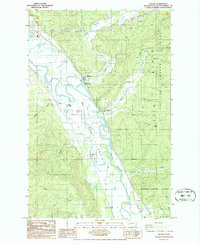
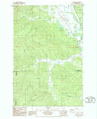
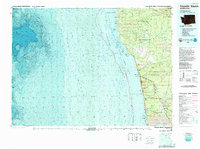 1980 Copalis Beach1988 Print · USGSThe Grays Harbor coast in the early eighties shows a landscape defined by the Quinault Indian Reservation and seaside rail history. Researchers can trace the Burlington Northern route through Moclips, Aloha, and Copalis Crossing.
 - 1981 Map of Mc Cleary
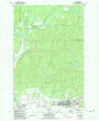
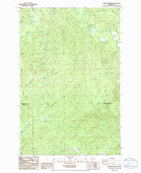
 1981 Mc Cleary1981 Print · USGSThe Grays Harbor and Mason County line comes alive in the early eighties, showing the timber-country settlements of McCleary and Garden City along the rail line. Researchers can trace the Burlington Northern tracks and locate sites like the Mark E Reed Memorial Hospital and Monkeys Prairie.
 - 1981 Map of Elma
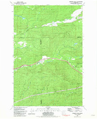
 1981 Elma1981 Print · USGSGrays Harbor County at the start of the eighties shows a landscape shaped by the Satsop River and the Burlington Northern line. Researchers can pinpoint property near Hunters Prairie, trace the Old RR Grade, or locate family sites by the Cem in Elma.
 - 1981 Map of Matlock, 1982 Print
 1981 Matlock1982 Print · USGSMason County’s logging and river landscape comes to life in the early 1980s, centered on the Matlock area. Researchers can trace the timber rail network from Frisken Wye to the Matlock Siding or locate sites like the Tornow Cemetery.
 - 1981 Map of Kamilche Valley, 1982 Print
 1981 Kamilche Valley1982 Print · USGSThe timberlands and valleys of Thurston and Mason counties are captured here in the early eighties. Genealogists and historians can trace the Burlington Northern rail line and locate landmarks like the Boy Scout Camp at Summit Lake and the Marmac settlement.
 - 1982 Map of Taholah
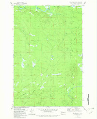
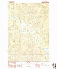
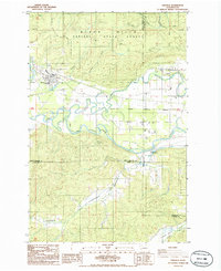
 1982 Taholah1982 Print · USGSCoastal Washington in the early eighties shows the settlement of Taholah at the mouth of the Quinault River. Researchers can trace the path of an Old Railroad Grade and locate geological curiosities like the Garfield Gas Mound and Gas Vent.2 unique versions available
 - 1982 Map of Macafee Hill
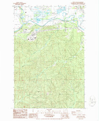
 1982 Macafee Hill1982 Print · USGSThe Olympic Peninsula's timberlands and tribal boundaries are captured here in the early eighties. Local researchers can trace the Quinault Indian Reservation Boundary and map old access routes near Chow Chow Prairie and Macafee Hill.2 unique versions available
 - 1982 Map of Shale Slough
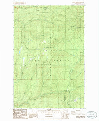
 1982 Shale Slough1982 Print · USGSThe Quinault Indian Reservation coast appears here in the early eighties, where the Quinault River meets the Pacific. Trace local landmarks like the Chow Chow Bridge, the Old Railroad Grade, and the Copalis National Wildlife Refuge.2 unique versions available
 - 1982 Map of Tunnel Island
 1982 Tunnel Island1982 Print · USGSThe Washington coast within the Quinault Indian Reservation is captured here in the early 1980s. Local history researchers can trace the intricate shoreline of the Raft River and identify named coastal landmarks like Elephant Rock and Pratt Cliff.2 unique versions available
 - 1982 Map of Queets
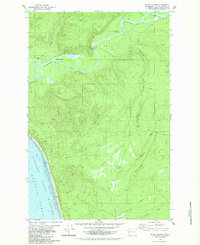
 1982 Queets1982 Print · USGSThe Olympic Peninsula coastline and its deep river valleys come into focus in the early eighties as the modern recreational and tribal landscape takes shape. Genealogists and historians can trace the foundations of Queets and Clearwater, locating the Queets-Clearwater Sch and early campgrounds like Kalaloch.
 - 1986 Map of Malone
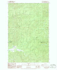
 1986 Malone1986 Print · USGSGrays Harbor County’s river-bottom lands and timbered ridges are captured here during the mid-1980s. Local researchers can trace the rural communities of Malone and Porter, find the Cem on the valley floor, and explore the heights of the Black Hills.2 unique versions available
 - 1986 Map of Brooklyn
 1986 Brooklyn1986 Print · USGSThe timber lands of the Grays Harbor and Pacific County border are captured here in the mid-1980s. Local researchers can trace old river-bottom sites like Brooklyn and Vesta, or locate the isolated Cem and Footbridge along the winding North River.2 unique versions available
 - 1986 Map of South Elma
 1986 South Elma1986 Print · USGSGrays Harbor County’s river valleys and timbered highlands are captured in the mid-1980s, showcasing the agricultural and industrial landscape south of the Chehalis. Researchers can trace historic locations like Weikswood or find local landmarks such as Saginaw, Fuller, and the Bay Scout Camp.2 unique versions available
 - 1986 Map of Capitol Peak
 1986 Capitol Peak1986 Print · USGSThe Black Hills of Washington are shown in the mid-1980s during a period of active timber and resource management. Forest historians can trace old logging access roads and recreation spots like the Wedekind Picnic Area and Sherman Valley Campground.2 unique versions available
 - 1986 Map of Cedarville
 1986 Cedarville1986 Print · USGSThe Chehalis River valley in the mid-1980s shows a landscape of timber management and river-bottom settlements. Researchers can trace the development of Cedarville and Independence or locate rural infrastructure like the Landing Strip and Old Road Grade.2 unique versions available
 - 1986 Map of Oakville
 1986 Oakville1986 Print · USGSThe river valleys of Grays Harbor and Thurston counties are captured here in the mid-1980s. You can trace the boundaries of the Chehalis Indian Reservation and locate rural landmarks like Gate, Independence, and the town of Oakville.2 unique versions available
 - 1986 Map of Blue Mountain
 1986 Blue Mountain1986 Print · USGSGrays Harbor and Pacific counties meet in this mid-1980s survey of the timbered hills around the North River. Researchers can trace remote creek systems like Raimie Creek and Redfield Creek, or locate the isolated Cem near the riverbank.2 unique versions available
 - 1986 Map of Central Park
 1986 Central Park1986 Print · USGSThe Grays Harbor river delta comes alive in the mid-1980s as the river system meets the growing community of Central Park. Trace the winding paths of Blue Slough and Preachers Slough or locate local landmarks like the Drive-in Theater and the settlement of Artic.2 unique versions available
 - 1986 Map of Elkhorn Creek
 1986 Elkhorn Creek1986 Print · USGSThe remote timberlands of the Willapa Hills are captured in the mid-1980s, documenting the border between Grays Harbor and Pacific counties. Researchers can trace the winding course of the North River and its many tributaries, including Star Hill and the West Fork Elkhorn Creek.2 unique versions available
 - 1986 Map of Montesano, 1993 Print
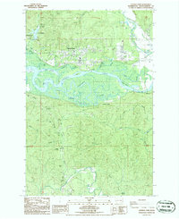
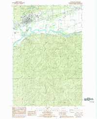 1986 Montesano1993 Print · USGSGrays Harbor County’s riverfront comes into focus during the mid-1980s as the Chehalis River valley balances industry and recreation. Researchers can trace property lines and landmarks from Montesano to Melbourne, including Lake Sylvia State Park and the local Cem.
 - 1988 Map of Shelton
 1988 Shelton1988 Print · USGSThe Olympic Peninsula's transition from high mountain wilderness to Puget Sound tideflats is captured here in the late eighties. Researchers can trace the path of the Logging Railroad or locate historical sites like Sanderson Field and the Skokomish Indian Reservation.
 - 1988 Map of Mount Olympus
 1988 Mount Olympus1988 Print · USGSThe Olympic Peninsula's glacial heart is captured here in the late eighties, documenting the reach of permanent ice and river headwaters. Trace the contours of the Bailey Range and identify landmarks like Sol Duc Hot Springs and the Seven Lakes Basin.
 - 1988 Map of Forks
 1988 Forks1988 Print · USGSThe Olympic Peninsula's western coastline and timber heartland are documented here in the late eighties, from the high ridges to the Pacific shelf. Local researchers can trace the coastal settlements of La Push and Mora or locate remote sites like Destruction Island.
 - 1989 Map of Westport
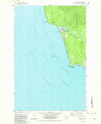
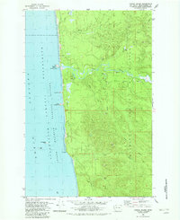
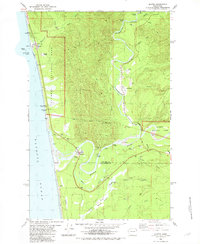
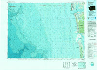 1989 Westport1989 Print · USGSThe Washington coast and the mouth of Grays Harbor are captured in the late eighties, documenting the maritime infrastructure and coastal settlements of the era. Researchers can trace the development of Westport, Ocean Shores, and historic waterfronts like Oysterville or Bay City.
End of results
Showing maps 1-24 of 24
Top cities of Grays Harbor County
- Aberdeen historical maps
- Hoquiam historical maps
- Ocean Shores historical maps
- Montesano historical maps
- Elma historical maps
- Westport historical maps
See more
Frequently asked questions
- What are the different types of historical maps available for Grays Harbor County?
- What is the oldest map of Grays Harbor County?
- Where can I purchase historical maps of Grays Harbor County for my home or office?
- Where can I download high-res historical maps of Grays Harbor County?
- Are there historical topographic maps available for Grays Harbor County?
- Is there historical aerial imagery available for Grays Harbor County?
- Where are historical maps of Grays Harbor County sourced from?