1940s Maps of Grays Harbor County, Washington
Explore 11 historic maps of Grays Harbor County from the 1940s. These maps offer a rare glimpse into what life looked like during the 1940s — showing old roads, neighborhoods, homes, and landmarks that have changed or disappeared over time.
Whether you're researching your family's past, planning a metal detecting trip, or studying how Grays Harbor County's landscape evolved across the 1940s, these high-resolution maps are a powerful tool for exploring the history of this region.
- Focus on a specific era: All maps on this page are from the 1940s, giving you a focused view of this time period.
- See what’s changed: Compare century-old streets, trails, and buildings to today's modern landscape using overlays and satellite layers.
- Research with precision: Use these maps for genealogy, historical research, land use analysis, or educational projects.
- View, download, or print: Maps are fully viewable online in high resolution, and can be downloaded or printed for your own records.
Start exploring Grays Harbor County's history through authentic maps from the 1940s. This is your window into the past.
Grays Harbor County, WA maps
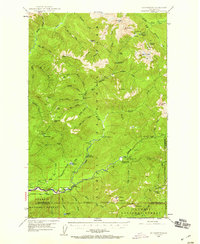
(11)- 1940 Map of Montesano
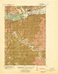 1940 Montesano1940 Print · USGSGrays Harbor and Pacific counties were defined by a massive river-and-rail network just before the war. You can trace the path of the Northern Pacific through Montesano or locate old timber operations along the Logging lines near Arctic and Vesta.
 - 1941 Map of Mobray
 1941 Mobray1941 Print · USGSCoastal Washington timberlands and river valleys come into focus in the early 1940s as industrial logging expands. Trace old family sites and works like Mobray, the Wynoochee Valley Farm, and the Simpson Logging Co Road.
 - 1941 Map of Moclips
 1941 Moclips1941 Print · USGSThe Grays Harbor coastline was a bustling corridor of timber and milling just before the war. Researchers can trace the extensive Polson Logging Company rail lines, the Carlisle School, and industrial sites like the Stearns Shingle Mill.
 - 1941 Map of Gate
 1941 Gate1941 Print · USGSThurston and Grays Harbor counties were bustling with rail and timber activity just before the mid-century. Researchers can trace the junction of four railroads near Gate or locate early rural sites like the Michigan Hill Sch and Jewelstock Ranch.
 - 1941 Map of Ford
 1941 Ford1941 Print · USGSGrays Harbor County at the brink of the Second World War shows a river valley shaped by logging and rail transit. Genealogists and historians can trace the early footprints of Malone, Cedarville, and Saginaw along the banks of the Chehalis River.2 unique versions available
 - 1941 Map of Grayland
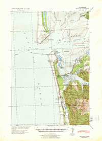 1941 Grayland1941 Print · USGSGrays Harbor and the Washington coast are captured here just before the mobilization of the early 1940s. Genealogists and historians can trace the foundations of Westport, locate the Western Logging Co Camp, and find maritime landmarks like the Grays Harbor L H.
 - 1943 Map of Humptulips
 1943 Humptulips1943 Print · USGSGrays Harbor County timber and ranching lands come into focus during the early 1940s as the region transitioned toward modern infrastructure. Researchers can locate family homesteads like Brittain Ranch, industrial sites like the Polson Logging Company lines, and local hubs including Springfield Sch and New London.
 - 1943 Map of Nahwatzel Lake
 1943 Nahwatzel Lake1943 Print · USGSThe timber country of Mason and Grays Harbor counties comes to life in this mid-century survey of the Satsop river system. Genealogists and historians can trace the Simpson Logging Co RR and locate landmarks like Oakhurst Sanitorium and Masonio Cem.
 - 1943 Map of Mobray
 1943 Mobray1943 Print · USGSGrays Harbor County at the dawn of the 1940s reveals a landscape shaped by the timber industry and river networks. Genealogists and historians can trace the operations of the Simpson Logging Company and find early settlements like Mobray and Monte along the Satsop River.
 - 1943 Map of Copalis Beach
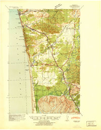
 1943 Copalis Beach1943 Print · USGSThe Washington coast in the 1940s is detailed here from the Olympic Peninsula to the Columbia River. Trace old beach settlements like Moclips and Copalis Beach alongside landmarks like the Willapa Bay Lighthouse.
 - 1947 Map of Mt Christie, 1959 Print
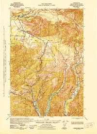
 1947 Mt Christie1959 Print · USGSThe Jefferson County high country in the late 1940s shows the early development of the national park system before modern road networks expanded. Researchers can trace historic mountain infrastructure including the Graves Creek Inn, Chicago Camp, and the Muncaster Sch.3 unique versions available
End of results
Showing maps 1-11 of 11
Top cities of Grays Harbor County
- Aberdeen historical maps
- Hoquiam historical maps
- Ocean Shores historical maps
- Montesano historical maps
- Elma historical maps
- Westport historical maps
See more
Frequently asked questions
- What are the different types of historical maps available for Grays Harbor County?
- What is the oldest map of Grays Harbor County?
- Where can I purchase historical maps of Grays Harbor County for my home or office?
- Where can I download high-res historical maps of Grays Harbor County?
- Are there historical topographic maps available for Grays Harbor County?
- Is there historical aerial imagery available for Grays Harbor County?
- Where are historical maps of Grays Harbor County sourced from?