Old Maps of Grays Harbor County, Washington for Academic Research
Study the evolution of Grays Harbor County with 164 high-resolution historic maps. Whether you're teaching, researching, or modeling changes in land use, these maps provide essential visual documentation of urban, environmental, and geographic change.
- Analyze long-term change: Track patterns in development, transportation, and natural features.
- Ideal for environmental or urban studies: Support academic projects with primary historical map data.
- Use in the classroom or lab: Educators and researchers rely on these maps to bring historical context to life.
These maps are a powerful tool for teaching, research, and visualizing how Grays Harbor County has changed over the decades.
Grays Harbor County, WA maps
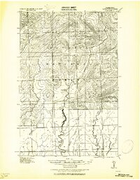
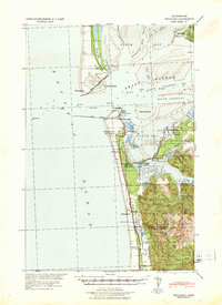
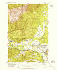
(164)- 1921 Map of Quinault Lake
 1921 Quinault Lake1921 Print · USGSThe western Olympic Peninsula comes into focus in the early 1920s as forestry and local travel began to reshape the river valleys. Researchers can trace the path of the Olympic Highway through the Quinault Indian Reservation past landmarks like Chow Chow Prairie and Lone Mt.
 - 1921 Map of Satsop
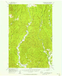
 1921 Satsop1921 Print · USGSThe Olympic wilderness and early timber frontiers are documented here in the early twenties as logging infrastructure moved into the river valleys. Researchers can trace the Simpson Logging R.R. and locate the original Wynoochee RS station.
 - 1938 Map of Moclips, 1961 Print
 1938 Moclips1961 Print · USGSCoastal Grays Harbor County comes alive in this pre-war survey of the Washington shoreline and its timber-driven interior. Genealogists and researchers can trace the rail spurs of the Northern Pacific and locate historic mills and settlements like Aloha, Carlisle, and Stearnsville.2 unique versions available
 - 1939 Map of Shelton
 1939 Shelton1939 Print · USGSSouth Puget Sound during the late thirties reveals a region defined by its timber-hauling railroads and intricate shorelines. Researchers can trace the legacy of early settlements and industry at Shelton, Kamilche, and transit points like Sawmill Sta or the Wilson Ranch.
 - 1940 Map of Montesano
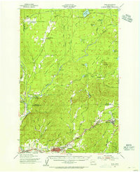
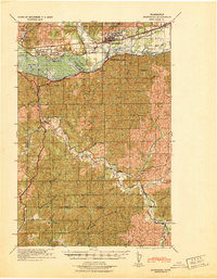 1940 Montesano1940 Print · USGSGrays Harbor and Pacific counties were defined by a massive river-and-rail network just before the war. You can trace the path of the Northern Pacific through Montesano or locate old timber operations along the Logging lines near Arctic and Vesta.
 - 1941 Map of Mobray
 1941 Mobray1941 Print · USGSCoastal Washington timberlands and river valleys come into focus in the early 1940s as industrial logging expands. Trace old family sites and works like Mobray, the Wynoochee Valley Farm, and the Simpson Logging Co Road.
 - 1941 Map of Moclips
 1941 Moclips1941 Print · USGSThe Grays Harbor coastline was a bustling corridor of timber and milling just before the war. Researchers can trace the extensive Polson Logging Company rail lines, the Carlisle School, and industrial sites like the Stearns Shingle Mill.
 - 1941 Map of Gate
 1941 Gate1941 Print · USGSThurston and Grays Harbor counties were bustling with rail and timber activity just before the mid-century. Researchers can trace the junction of four railroads near Gate or locate early rural sites like the Michigan Hill Sch and Jewelstock Ranch.
 - 1941 Map of Ford
 1941 Ford1941 Print · USGSGrays Harbor County at the brink of the Second World War shows a river valley shaped by logging and rail transit. Genealogists and historians can trace the early footprints of Malone, Cedarville, and Saginaw along the banks of the Chehalis River.2 unique versions available
 - 1941 Map of Grayland
 1941 Grayland1941 Print · USGSGrays Harbor and the Washington coast are captured here just before the mobilization of the early 1940s. Genealogists and historians can trace the foundations of Westport, locate the Western Logging Co Camp, and find maritime landmarks like the Grays Harbor L H.
 - 1943 Map of Humptulips
 1943 Humptulips1943 Print · USGSGrays Harbor County timber and ranching lands come into focus during the early 1940s as the region transitioned toward modern infrastructure. Researchers can locate family homesteads like Brittain Ranch, industrial sites like the Polson Logging Company lines, and local hubs including Springfield Sch and New London.
 - 1943 Map of Nahwatzel Lake
 1943 Nahwatzel Lake1943 Print · USGSThe timber country of Mason and Grays Harbor counties comes to life in this mid-century survey of the Satsop river system. Genealogists and historians can trace the Simpson Logging Co RR and locate landmarks like Oakhurst Sanitorium and Masonio Cem.
 - 1943 Map of Mobray
 1943 Mobray1943 Print · USGSGrays Harbor County at the dawn of the 1940s reveals a landscape shaped by the timber industry and river networks. Genealogists and historians can trace the operations of the Simpson Logging Company and find early settlements like Mobray and Monte along the Satsop River.
 - 1943 Map of Copalis Beach
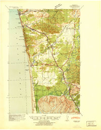
 1943 Copalis Beach1943 Print · USGSThe Washington coast in the 1940s is detailed here from the Olympic Peninsula to the Columbia River. Trace old beach settlements like Moclips and Copalis Beach alongside landmarks like the Willapa Bay Lighthouse.
 - 1947 Map of Mt Christie, 1959 Print
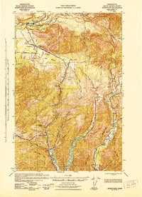
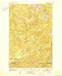
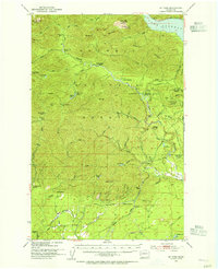
 1947 Mt Christie1959 Print · USGSThe Jefferson County high country in the late 1940s shows the early development of the national park system before modern road networks expanded. Researchers can trace historic mountain infrastructure including the Graves Creek Inn, Chicago Camp, and the Muncaster Sch.3 unique versions available
 - 1950 Map of Mt Christie
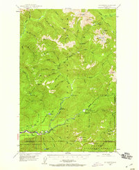
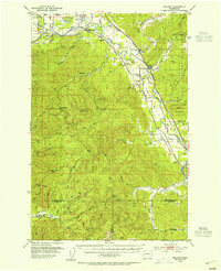
 1950 Mt Christie1950 Print · USGSJefferson and Grays Harbor counties appear here during the mid-century, showing a landscape of backcountry shelters and mountain trails. You can trace the routes of early hikers and rangers through Graves Creek Inn, the Muncaster Sch, and Chicago Camp.2 unique versions available
 - 1951 Map of Copalis Beach
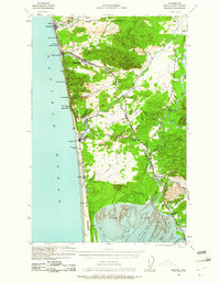
 1951 Copalis Beach1951 Print · USGSThe Olympic Peninsula's rugged coast and tribal lands are meticulously detailed in the early 1950s. Genealogists and historians can trace the foundations of coastal communities from Taholah to La Push or locate early markers like the James Island Lighthouse.
 - 1953 Map of Hoquiam
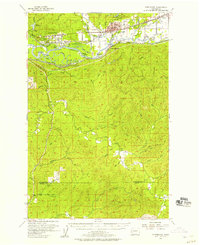
 1953 Hoquiam1953 Print · USGSSouthwest Washington in the early fifties shows a landscape shaped by timber, rail, and river commerce from the coast to the Cascades. Genealogists and historians can trace the development of timber towns like Ryderwood and the industrial hubs of Hoquiam and Kelso.2 unique versions available
 - 1953 Map of Rochester, 1955 Print
 1953 Rochester1955 Print · USGSThurston and Lewis counties in the early fifties reveal a dense network of timberlands and river-bottom farms. Genealogists can locate the Finnish Cem and Grand Mound Cem, or trace the Fort Henness Site and the vanished logging community of Bordeaux.3 unique versions available
 - 1953 Map of Mt Tebo, 1955 Print
 1953 Mt Tebo1955 Print · USGSThe Mason and Grays Harbor county line was a hub of timber production and wilderness management in the 1950s. Genealogists and historians can trace old logging infrastructure like Fir Creek Reload, primitive campsites at Camp 3 (Site), and the remote Le Bar Guard Sta.3 unique versions available
 - 1953 Map of Malone, 1955 Print
 1953 Malone1955 Print · USGSThe Chehalis River valley was a bustling rail corridor in the mid-1950s, supporting timber towns and riverside communities. Genealogists and historians can trace rail stops at Malone and Porter, find the Sharon Cem, or locate the North River Consolidated Sch.3 unique versions available
 - 1953 Map of Shelton, 1956 Print
 1953 Shelton1956 Print · USGSThe Mason County waterfront and its timbered interior come alive in this mid-century survey of the inlets surrounding Shelton. Trace the legacy of rural education and military history at Bordeaux Sch, New Kamilche, and the Naval Auxiliary Air Station.2 unique versions available
 - 1953 Map of Elma, 1956 Print
 1953 Elma1956 Print · USGSGrays Harbor and Mason Counties come alive in the early fifties, showing a region defined by its timber economy and river valleys. Genealogists and historians can trace rail-side settlements like Deckerville, Rayville, and Elma, or locate family sites near Turnow Cem and the Mary M Knight School.2 unique versions available
 - 1955 Map of Montesano, 1957 Print
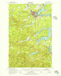
 1955 Montesano1957 Print · USGSThe river-and-rail hub of Montesano is captured here in the mid-fifties as the timber economy shaped the Chehalis valley. Genealogists can trace family names at Brick Ch or locate vanished sites like Artic and the rural community of Brooklyn.3 unique versions available
 - 1955 Map of Wynoochee Valley, 1957 Print
 1955 Wynoochee Valley1957 Print · USGSGrays Harbor County’s timber country comes alive in the mid-1950s as logging operations reshape the river valleys. Local historians can trace the Middle Fork Railroad, locate the Wynoochee Grange, and find fire watch sites like McGray Lookout.3 unique versions available
Showing maps 1-25 of 164
Top cities of Grays Harbor County
- Aberdeen historical maps
- Hoquiam historical maps
- Ocean Shores historical maps
- Montesano historical maps
- Elma historical maps
- Westport historical maps
See more
Frequently asked questions
- What are the different types of historical maps available for Grays Harbor County?
- What is the oldest map of Grays Harbor County?
- Where can I purchase historical maps of Grays Harbor County for my home or office?
- Where can I download high-res historical maps of Grays Harbor County?
- Are there historical topographic maps available for Grays Harbor County?
- Is there historical aerial imagery available for Grays Harbor County?
- Where are historical maps of Grays Harbor County sourced from?