1900s (20th Century) Maps of Island County, Washington
Explore 53 historic maps of Island County from the 1900s (20th Century). These maps offer a rare glimpse into what life looked like during the 1900s — showing old roads, neighborhoods, homes, and landmarks that have changed or disappeared over time.
Whether you're researching your family's past, planning a metal detecting trip, or studying how Island County's landscape evolved across the 1900s, these high-resolution maps are a powerful tool for exploring the history of this region.
- Focus on a specific era: All maps on this page are from the 1900s, giving you a focused view of this time period.
- See what’s changed: Compare century-old streets, trails, and buildings to today's modern landscape using overlays and satellite layers.
- Research with precision: Use these maps for genealogy, historical research, land use analysis, or educational projects.
- View, download, or print: Maps are fully viewable online in high resolution, and can be downloaded or printed for your own records.
Start exploring Island County's history through authentic maps from the 1900s. This is your window into the past.
Island County, WA maps
(53)- 1911 Map of Mount Vernon
 1911 Mount Vernon1911 Print · USGSSkagit and Snohomish counties are shown here just after the turn of the century as the railroad and river networks fueled rapid growth. Researchers can trace historic transportation routes like the Anderson Ferry and the Monte Cristo RR through Mount Vernon and the Tulalip Indian Reservation.4 unique versions available
 - 1937 Map of Port Gamble, 1964 Print
 1937 Port Gamble1964 Print · USGSPuget Sound and the Hood Canal meet in the 1930s, showing a world of timber mills and vital ferry crossings. Trace the old routes of the Port Gamble-Shine Auto Ferry and locate historic landmarks like the Point No Point Lighthouse and Indianola.
 - 1939 Map of Port Townsend
 1939 Port Townsend1939 Print · USGSCoastal Jefferson County in the late 1930s serves as a vital maritime and military hub at the edge of the Strait of Juan de Fuca. Genealogists and historians can trace family-named sites like Clark Farm alongside major landmarks like Fort Worden and the busy docks of Irondale.
 - 1939 Map of Coupeville
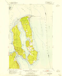
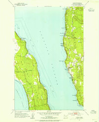
 1939 Coupeville1939 Print · USGSWhidbey and Marrowstone Islands are captured in the late 1930s when military forts and ferry lines still dictated the rhythm of Puget Sound. Researchers can trace the grounds of Fort Casey, locate the Island County Courthouse, and find vanished coastal landmarks like Pratts Resort.
 - 1940 Map of Port Gamble
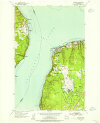
 1940 Port Gamble1940 Print · USGSThe Kitsap Peninsula and Hood Canal are seen here in the final years before the bridge era, when a complex network of ferries was the lifeblood of the sound. Genealogists and local historians can trace the early footprints of Port Gamble, Hansville, and the Port Madison Indian Reservation.
 - 1940 Map of Mt Vernon, 1957 Print
 1940 Mt Vernon1957 Print · USGSThe Skagit River delta and its thriving rail-and-river towns are captured here just before the mid-century. Genealogists can trace family roots through numerous country schools like Harmony Sch and landmarks like the Milltown Ch or the timber-hauling Logging Railroad.2 unique versions available
 - 1942 Map of Edmonds, 1944 Print
 1942 Edmonds1944 Print · USGSCoastal Snohomish County and Whidbey Island are captured in the early 1940s during a period of maritime and rail expansion. Researchers can trace historic ferry lines, the Great Northern railroad, and local landmarks like Alderwood Manor and Firlands Sanitarium.
 - 1943 Map of Mt Vernon
 1943 Mt Vernon1943 Print · USGSSkagit County during the early years of the war reveals a complex network of river deltas and rail-dependent settlements. Researchers can trace the heritage of rural communities through labels for Skagit City, the Ridgeway Sch, and the Great Northern railroad.2 unique versions available
 - 1943 Map of Stanwood
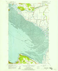
 1943 Stanwood1943 Print · USGSThe Puget Sound shoreline comes alive in the early 1940s, showing the intricate waterways and settlements surrounding the Stillaguamish River delta. Genealogists and local historians can trace schoolhouse locations like School No 203 or coastal communities such as Langley and Mabana.2 unique versions available
 - 1943 Map of Richardson
 1943 Richardson1943 Print · USGSLopez Island and the surrounding San Juan archipelago are captured here in the early forties, showing a coastal landscape of maritime hamlets and isolated island life. You can trace early school sites like Center Sch and the harbor at Richardson, or locate the remote Smith Island National Wild Life Refuge.
 - 1943 Map of Deception Pass
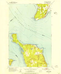
 1943 Deception Pass1943 Print · USGSFidalgo and Whidbey Islands are shown in the early 1940s, highlighting the maritime and rail connections of Puget Sound. Researchers can trace the boundaries of the Swinomish Indian Reservation or locate early schools like Fidalgo Sch and Dewey Sch.
 - 1951 Map of Deception Pass, 1953 Print
 1951 Deception Pass1953 Print · USGSWhidbey and Fidalgo Islands appear here in the early fifties as the region's naval and agricultural identities merged. Genealogists and local historians can trace early schools and coastal landmarks like Rosario School, Fort Whitman, and the village of La Conner.3 unique versions available
 - 1953 Map of Hansville, 1954 Print
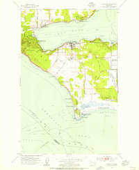
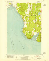
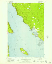
 1953 Hansville1954 Print · USGSThe northern Kitsap Peninsula and Whidbey Island are shown in the early 1950s, a period of quiet maritime life along the Admiralty Inlet. You can trace early coastal settlements like Hansville and Austin, or locate landmarks such as the Point No Point lighthouse and Cemetery.3 unique versions available
 - 1953 Map of Coupeville, 1955 Print
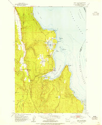
 1953 Coupeville1955 Print · USGSWhidbey Island in the early fifties shows a balance of historic prairie farming and vital Cold War military operations. Researchers can trace the legacy of Coupeville and Ebeys Landing or locate maritime landmarks like the Keystone Ferry Landing and the Lighthouse (Aband'd).3 unique versions available
 - 1953 Map of Freeland, 1955 Print
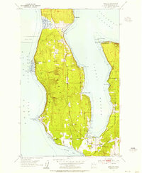 1953 Freeland1955 Print · USGSWhidbey Island in the early fifties shows a transition from rural homesteads to established coastal communities along Holmes Harbor. You can trace the maritime footprint of Bush Point and its Lighthouse or locate family sites near Freeland and Honeymoon Bay.6 unique versions available
 - 1953 Map of Edmonds West, 1955 Print
 1953 Edmonds West1955 Print · USGSPuget Sound communities and industrial shorelines are captured in detail during the early fifties. Genealogists and historians can trace the mid-century footprints of Edmonds and Kingston, or locate specific landmarks like the Naval Reservation and Point Wells facilities.5 unique versions available
 - 1953 Map of Nordland, 1955 Print
 1953 Nordland1955 Print · USGSJefferson County’s coastal islands and military outposts are documented here in the early fifties, showing the area's transition into a strategic naval hub. Genealogists and researchers can locate Nordland, trace family plots at Sound View Cemetery, and explore the grounds of Fort Flagler Military Reservation.4 unique versions available
 - 1953 Map of Port Ludlow, 1955 Print
 1953 Port Ludlow1955 Print · USGSJefferson County’s shoreline in the early fifties reveals a maritime community centered on sheltered bays and timbered valleys. Researchers can locate the historic Port Ludlow Post Office and trace the roads connecting Swansonville and the Mats Mats Quarry.3 unique versions available
 - 1953 Map of Maxwelton, 1955 Print
 1953 Maxwelton1955 Print · USGSSouthern Whidbey Island in the early fifties reveals a landscape of tidal lagoons and established shoreline communities. Genealogists and historians can trace the foundations of Sunlight Beach, locate the Gravel Pit, or map the early footprints of Maxwelton and Possession.4 unique versions available
 - 1953 Map of Mukilteo, 1955 Print
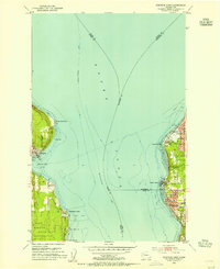
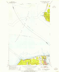
 1953 Mukilteo1955 Print · USGSThe Mukilteo coastline and Whidbey Island are captured here in the early fifties, just as the local aviation and military presence was expanding. Trace the early layout of Paine Field, find the Lighthouse at Elliot Point, and follow the Ferry crossing to Clinton.5 unique versions available
 - 1953 Map of Camano, 1955 Print
 1953 Camano1955 Print · USGSThe Puget Sound islands in the early fifties show a transition from rural homesteads to a coastal retreat. Trace the shoreline settlements of Madrona Beach and Cama Beach or the military grounds of the Whidbey Island Naval Air Station.4 unique versions available
 - 1953 Map of Port Townsend North, 1955 Print
 1953 Port Townsend North1955 Print · USGSThe entrance to Puget Sound in the early fifties shows a landscape shaped by coastal defense and maritime commerce. Trace the grounds of Fort Worden Military Res, the lighthouse at Point Wilson, and the ferry lanes crossing the Strait of Juan de Fuca.3 unique versions available
 - 1953 Map of Edmonds, 1958 Print
 1953 Edmonds1958 Print · USGSThe Snohomish County shoreline and southern Whidbey Island were undergoing a massive suburban shift in the early fifties. Researchers can trace the growth of Mountlake Terrace, locate old schoolhouses like Fairmont School, and find the Paine Field Air Force Base.
 - 1956 Map of Tulalip, 1957 Print
 1956 Tulalip1957 Print · USGSThe Snohomish County shoreline in the mid-fifties is captured here during a period of quiet coastal growth along the sound. Researchers can trace early waterfront developments like Spee-Bi-Dah and Tulalip Shores alongside landmarks like Gedney Island.4 unique versions available
 - 1956 Map of Utsalady, 1957 Print
 1956 Utsalady1957 Print · USGSCoastal Skagit County and the northern tip of Camano Island are shown here in the mid-fifties during a period of steady maritime and agricultural life. Researchers can trace historic family-named routes like Maupin Road and locate the waterfront community of Utsalady or the timber-related English Boom.3 unique versions available
Showing maps 1-25 of 53
Top cities of Island County
- Oak Harbor historical maps
- Freeland historical maps
- Coupeville historical maps
- Langley historical maps
- Clinton historical maps
Frequently asked questions
- What are the different types of historical maps available for Island County?
- What is the oldest map of Island County?
- Where can I purchase historical maps of Island County for my home or office?
- Where can I download high-res historical maps of Island County?
- Are there historical topographic maps available for Island County?
- Is there historical aerial imagery available for Island County?
- Where are historical maps of Island County sourced from?