1970s Maps of Island County, Washington
Explore 8 historic maps of Island County from the 1970s. These maps offer a rare glimpse into what life looked like during the 1970s — showing old roads, neighborhoods, homes, and landmarks that have changed or disappeared over time.
Whether you're researching your family's past, planning a metal detecting trip, or studying how Island County's landscape evolved across the 1970s, these high-resolution maps are a powerful tool for exploring the history of this region.
- Focus on a specific era: All maps on this page are from the 1970s, giving you a focused view of this time period.
- See what’s changed: Compare century-old streets, trails, and buildings to today's modern landscape using overlays and satellite layers.
- Research with precision: Use these maps for genealogy, historical research, land use analysis, or educational projects.
- View, download, or print: Maps are fully viewable online in high resolution, and can be downloaded or printed for your own records.
Start exploring Island County's history through authentic maps from the 1970s. This is your window into the past.
Island County, WA maps
(8)- 1973 Map of Lopez Pass, 1977 Print
 1973 Lopez Pass1977 Print · USGSThe eastern shores of the San Juan archipelago are captured here in the early 1970s, showing a landscape defined by saltwater sounds and rocky headlands. Researchers can trace the boundaries of the San Juan Islands National Wildlife Refuge and locate remote landmarks like Davidson Rock Light and Chadwick Hill.2 unique versions available
 - 1973 Map of Oak Harbor, 1977 Print
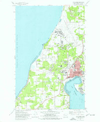 1973 Oak Harbor1977 Print · USGSWhidbey Island during the early seventies reveals the massive infrastructure of Ault Field alongside a growing Oak Harbor. Researchers can trace local heritage through sites like Maple Leaf Cem, Clover Valley School, and the Drive-in Theater.3 unique versions available
 - 1975 Map of Seattle, 1977 Print
 1975 Seattle1977 Print · USGSThe Puget Sound region in the mid-seventies shows a landscape of rapid suburban growth and vital maritime industry. Researchers can trace the development of Eastside hubs like Bellevue or examine the rail and naval infrastructure of Bremerton and Paine Field.
 - 1975 Map of Port Townsend, 1977 Print
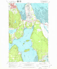
 1975 Port Townsend1977 Print · USGSThe northern Puget Sound in the mid-seventies shows a landscape of military readiness and maritime industry. Researchers can trace the extensive Whidbey Island Naval Air Station or locate historic coastal defenses at Fort Casey Military Res and Fort Ebey Military Res.
 - 1977 Map of Crescent Harbor, 1978 Print
 1977 Crescent Harbor1978 Print · USGSWhidbey Island and the northern tip of Camano Island are shown during the late seventies, a time of significant naval presence and rural development. Researchers can trace land use through family-named routes like Elstad Way and locate the sprawling U S Naval Air Station and Maple Grove Beach.3 unique versions available
 - 1978 Map of Anacortes South, 1979 Print
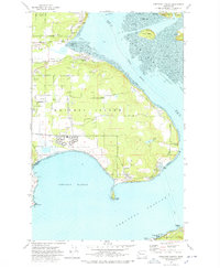
 1978 Anacortes South1979 Print · USGSSkagit County's coastal landscape appears in transition during the late seventies, balancing heavy industry with island recreation. Researchers can trace the boundaries of the Swinomish Ind Res Bdy and locate local landmarks like Summit Hall, Fidalgo Sch, and the Drive-in Theater.3 unique versions available
 - 1978 Map of Smith Island, 1981 Print
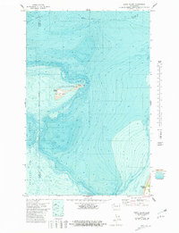 1978 Smith Island1981 Print · USGSThe eastern reaches of the Strait of Juan de Fuca are documented here in the late seventies, showing the isolated Smith Island and its surrounding waters. Trace the maritime landscape of the San Juan Islands National Wildlife Refuge, including a Cistern and Light on the island.
 - 1978 Map of Deception Pass, 1986 Print
 1978 Deception Pass1986 Print · USGSThe islands of Fidalgo and Whidbey meet at the turbulent waters of Deception Pass during the late seventies. Researchers can trace local landmarks like the Cemetery, Mt Erie, and the coastal Coast Guard Res.
End of results
Showing maps 1-8 of 8
Top cities of Island County
- Oak Harbor historical maps
- Freeland historical maps
- Coupeville historical maps
- Langley historical maps
- Clinton historical maps
Frequently asked questions
- What are the different types of historical maps available for Island County?
- What is the oldest map of Island County?
- Where can I purchase historical maps of Island County for my home or office?
- Where can I download high-res historical maps of Island County?
- Are there historical topographic maps available for Island County?
- Is there historical aerial imagery available for Island County?
- Where are historical maps of Island County sourced from?