1990s Maps of Island County, Washington
Explore 14 historic maps of Island County from the 1990s. These maps offer a rare glimpse into what life looked like during the 1990s — showing old roads, neighborhoods, homes, and landmarks that have changed or disappeared over time.
Whether you're researching your family's past, planning a metal detecting trip, or studying how Island County's landscape evolved across the 1990s, these high-resolution maps are a powerful tool for exploring the history of this region.
- Focus on a specific era: All maps on this page are from the 1990s, giving you a focused view of this time period.
- See what’s changed: Compare century-old streets, trails, and buildings to today's modern landscape using overlays and satellite layers.
- Research with precision: Use these maps for genealogy, historical research, land use analysis, or educational projects.
- View, download, or print: Maps are fully viewable online in high resolution, and can be downloaded or printed for your own records.
Start exploring Island County's history through authentic maps from the 1990s. This is your window into the past.
Island County, WA maps
(14)- 1992 Map of Seattle, 1993 Print
 1992 Seattle1993 Print · USGSThe Seattle metropolitan area and Puget Sound are shown here in the early nineties during a period of rapid suburban and technological growth. Researchers can trace the development of Mercer Island, locate the Bangor Naval Submarine Base, and study the industrial layout of Boeing Field.2 unique versions available
 - 1993 Map of Port Townsend
 1993 Port Townsend1993 Print · USGSThe Puget Sound and Whidbey Island are captured in the early nineties, showing a landscape defined by naval aviation and maritime trade. Genealogists and local historians can trace the development of Oak Harbor and Coupeville or locate family sites near the Arlington Municipal Cemetery and Ault Field.
 - 1997 Map of Edmonds West, 2003 Print
 1997 Edmonds West2003 Print · USGSPuget Sound’s busy maritime corridor is captured here in the late nineties, documenting the evolving shoreline from the Kitsap Peninsula to Edmonds. Maritime researchers can trace ferry lanes, locate a Sunken Wreck near Apple Cove Point, and see industrial sites like the oil tanks at Point Wells.
 - 1997 Map of Hansville, 2003 Print
 1997 Hansville2003 Print · USGSThe northern tip of the Kitsap Peninsula is captured here in the late twentieth century, showing a landscape defined by maritime landmarks and quiet coastal settlements. Genealogists and local historians can trace the roads around Hansville, locate the Cem, and see prominent points like Point No Point and Foulweather Bluff.
 - 1997 Map of Maxwelton, 2003 Print
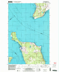
 1997 Maxwelton2003 Print · USGSSouthern Whidbey Island in the late nineties shows a landscape of tidal lagoons and established coastal communities. You can trace local landmarks like Sunlight Beach, the wetlands of Deer Lagoon, and the prominent landmarks of Scatchet Head and Possession Point.
 - 1998 Map of Lopez Pass, 2001 Print
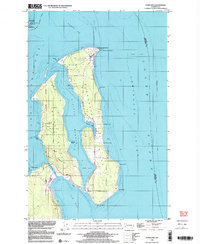
 1998 Lopez Pass2001 Print · USGSThe San Juan Islands in the late twentieth century reveal a landscape of secluded bays and protected wildlife sanctuaries. Researchers can trace land use near Pavey Blvd or explore the rocky coastline from Pt Colville to the quiet waters of Mackaye Harbor.
 - 1998 Map of Deception Pass, 2002 Print
 1998 Deception Pass2002 Print · USGSThe northern tip of Whidbey Island meets Fidalgo Island in the late nineties, documenting the critical maritime junction of Deception Pass. Trace the local geography from the peak of Mt Erie to the residential streets of Anacortes and Rosario Beach.
 - 1998 Map of Crescent Harbor, 2002 Print
 1998 Crescent Harbor2002 Print · USGSNorthern Whidbey Island appears here at the close of the century, centered on the strategic waterfront. Trace the footprint of Whidbey Island Naval Air Station and coastal landmarks like Strawberry Point and Maple Grove Beach.
 - 1998 Map of Smith Island, 2002 Print
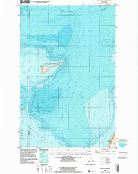 1998 Smith Island2002 Print · USGSIsolation and maritime safety define these outposts in the Strait of Juan de Fuca during the late nineties. Maritime researchers can locate the Light and Cistern on Smith Island or trace the underwater contours of Partridge Bank.
 - 1998 Map of Oak Harbor, 2002 Print
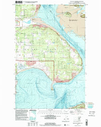
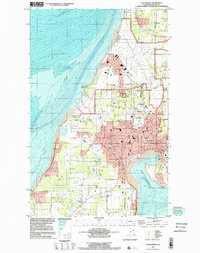 1998 Oak Harbor2002 Print · USGSWhidbey Island is captured in the late nineties as a mix of strategic naval operations and growing island communities. Genealogists and historians can trace property near Maple Leaf Cem or the airfield at Whidbey Island Naval Air Station.
 - 1998 Map of Anacortes South, 2002 Print
 1998 Anacortes South2002 Print · USGSFidalgo Island's maritime and industrial landscape is captured in the late nineties, from the refineries of Anacortes to the waters of Skagit Bay. Trace local family roots at Fern Hill Cem or study the shoreline near Gibraltar and Kiket Island.
 - 1998 Map of Freeland, 2003 Print
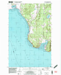
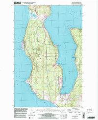 1998 Freeland2003 Print · USGSWhidbey Island's central coast near the close of the century shows a unique mix of naval operations and seaside communities. Trace the shoreline from the Bush Point Lighthouse to the Lake Hancock Target Range or the quiet roads of Greenbank.
 - 1998 Map of Nordland, 2003 Print
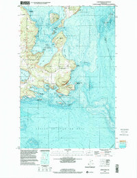
 1998 Nordland2003 Print · USGSMarrowstone and Indian Islands appear here at the close of the twentieth century, showing a landscape defined by military history and maritime life. Researchers can locate Sound View Cemetery, the Lighthouse at Marrowstone Point, and the village of Nordland.
 - 1998 Map of Utsalady, 2003 Print
 1998 Utsalady2003 Print · USGSThe Skagit River delta meets the Salish Sea in the late nineties, showing a landscape of fertile islands and tidal flats. Genealogists and historians can trace coastal settlements like Utsalady and Fish Town, or the historic timber site at English Boom near Utsalady Pt.
End of results
Showing maps 1-14 of 14
Top cities of Island County
- Oak Harbor historical maps
- Freeland historical maps
- Coupeville historical maps
- Langley historical maps
- Clinton historical maps
Frequently asked questions
- What are the different types of historical maps available for Island County?
- What is the oldest map of Island County?
- Where can I purchase historical maps of Island County for my home or office?
- Where can I download high-res historical maps of Island County?
- Are there historical topographic maps available for Island County?
- Is there historical aerial imagery available for Island County?
- Where are historical maps of Island County sourced from?