1930s Maps of Jefferson County, Washington
Explore 9 historic maps of Jefferson County from the 1930s. These maps offer a rare glimpse into what life looked like during the 1930s — showing old roads, neighborhoods, homes, and landmarks that have changed or disappeared over time.
Whether you're researching your family's past, planning a metal detecting trip, or studying how Jefferson County's landscape evolved across the 1930s, these high-resolution maps are a powerful tool for exploring the history of this region.
- Focus on a specific era: All maps on this page are from the 1930s, giving you a focused view of this time period.
- See what’s changed: Compare century-old streets, trails, and buildings to today's modern landscape using overlays and satellite layers.
- Research with precision: Use these maps for genealogy, historical research, land use analysis, or educational projects.
- View, download, or print: Maps are fully viewable online in high resolution, and can be downloaded or printed for your own records.
Start exploring Jefferson County's history through authentic maps from the 1930s. This is your window into the past.
Jefferson County, WA maps
(9)- 1935 Map of Mount Olympus, 1954 Print
 1935 Mount Olympus1954 Print · USGSThe high peaks and glaciers of the Olympic Range are shown here as they appeared in the 1930s. Researchers can locate remote backcountry landmarks like Michaels Ranch, the Olympus Guard Station, and the old Hurricane Hill Lookout.
 - 1936 Map of Point Misery, 1958 Print
 1936 Point Misery1958 Print · USGSCommunities along the Hood Canal thrived on timber and maritime trade in the mid-1930s. Genealogists and historians can trace local landmarks like Seabeck, the Lewis Lumber Co, and the Brinnon Seabeck Ferry route.3 unique versions available
 - 1937 Map of Port Orchard, 1960 Print
 1937 Port Orchard1960 Print · USGSBremerton and the Kitsap Peninsula were defined by their deep-water naval facilities and ferry networks in the years preceding World War II. Local historians can trace the early footprints of the Puget Sound Navy Yard, the Port Madison Indian Reservation, and the Fort Ward coastal defenses.2 unique versions available
 - 1937 Map of Port Gamble, 1964 Print
 1937 Port Gamble1964 Print · USGSPuget Sound and the Hood Canal meet in the 1930s, showing a world of timber mills and vital ferry crossings. Trace the old routes of the Port Gamble-Shine Auto Ferry and locate historic landmarks like the Point No Point Lighthouse and Indianola.
 - 1938 Map of Mt Constance
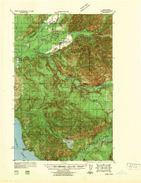
 1938 Mt Constance1938 Print · USGSThe eastern Olympic Peninsula comes into focus in the 1930s as a land of massive peaks and nascent federal parks. Trace the early mining efforts at the Tubal Cain Mine, lookouts like Deer Park Lookout, and the shoreline at Eldon.4 unique versions available
 - 1939 Map of Port Townsend
 1939 Port Townsend1939 Print · USGSCoastal Jefferson County in the late 1930s serves as a vital maritime and military hub at the edge of the Strait of Juan de Fuca. Genealogists and historians can trace family-named sites like Clark Farm alongside major landmarks like Fort Worden and the busy docks of Irondale.
 - 1939 Map of Forks
 1939 Forks1939 Print · USGSThe Olympic Peninsula logging and oil frontier comes into focus here just before the Second World War. Researchers can trace family homesteads like the Otto Dimmel Ranch alongside industrial landmarks like the Bloedel Donovan Beaver Camp and Oil City Camp.
 - 1939 Map of Coupeville
 1939 Coupeville1939 Print · USGSWhidbey and Marrowstone Islands are captured in the late 1930s when military forts and ferry lines still dictated the rhythm of Puget Sound. Researchers can trace the grounds of Fort Casey, locate the Island County Courthouse, and find vanished coastal landmarks like Pratts Resort.
 - 1939 Map of Mount Tom
 1939 Mount Tom1939 Print · USGSThe Olympic Peninsula wilderness comes into sharp focus during the late 1930s as park and forest boundaries are established. Researchers can trace early trail networks connecting Sol Duc Hot Springs, Mt Tom Shelter, and remote guard stations like Eagle GS.
End of results
Showing maps 1-9 of 9
Top cities of Jefferson County
- Port Townsend historical maps
- Port Hadlock historical maps
- Port Ludlow historical maps
- Brinnon historical maps
- Quilcene historical maps
Frequently asked questions
- What are the different types of historical maps available for Jefferson County?
- What is the oldest map of Jefferson County?
- Where can I purchase historical maps of Jefferson County for my home or office?
- Where can I download high-res historical maps of Jefferson County?
- Are there historical topographic maps available for Jefferson County?
- Is there historical aerial imagery available for Jefferson County?
- Where are historical maps of Jefferson County sourced from?