1950s Maps of Jefferson County, Washington
Explore 38 historic maps of Jefferson County from the 1950s. These maps offer a rare glimpse into what life looked like during the 1950s — showing old roads, neighborhoods, homes, and landmarks that have changed or disappeared over time.
Whether you're researching your family's past, planning a metal detecting trip, or studying how Jefferson County's landscape evolved across the 1950s, these high-resolution maps are a powerful tool for exploring the history of this region.
- Focus on a specific era: All maps on this page are from the 1950s, giving you a focused view of this time period.
- See what’s changed: Compare century-old streets, trails, and buildings to today's modern landscape using overlays and satellite layers.
- Research with precision: Use these maps for genealogy, historical research, land use analysis, or educational projects.
- View, download, or print: Maps are fully viewable online in high resolution, and can be downloaded or printed for your own records.
Start exploring Jefferson County's history through authentic maps from the 1950s. This is your window into the past.
Jefferson County, WA maps
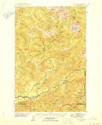
(38)- 1950 Map of The Brothers
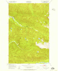
 1950 The Brothers1950 Print · USGSThe Jefferson County coast meets the Olympic peaks in the mid-century, capturing the area's transition from the Hood Canal shoreline to high wilderness. Researchers can trace early backcountry camps and coastal landmarks like John Ahl Sch, Camp Collins, and the Hamma Hamma Guard Sta.2 unique versions available
 - 1950 Map of Mt Christie
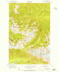
 1950 Mt Christie1950 Print · USGSJefferson and Grays Harbor counties appear here during the mid-century, showing a landscape of backcountry shelters and mountain trails. You can trace the routes of early hikers and rangers through Graves Creek Inn, the Muncaster Sch, and Chicago Camp.2 unique versions available
 - 1950 Map of Mt. Steel
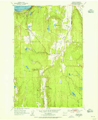
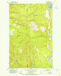
 1950 Mt. Steel1950 Print · USGSThe interior Olympic Peninsula at mid-century reveals a high-country wilderness of glaciers and remote outposts. Trace the locations of backcountry sites like Chalet, Hammer Cabin, and the Darky Mine along the North Fork Skokomish River.2 unique versions available
 - 1950 Map of Hurricane Hill, 1955 Print
 1950 Hurricane Hill1955 Print · USGSThe wilderness of Clallam County is captured in the mid-century as early ranching and park infrastructure met the high peaks. Trace the primitive trail system and historic sites like Michaels Ranch, Whiskey Bend, and the Hurricane Hill Lookout.5 unique versions available
 - 1950 Map of Slide Peak, 1956 Print
 1950 Slide Peak1956 Print · USGSClallam and Jefferson counties are captured here in the mid-twentieth century, showcasing the deep wilderness of the Olympic Peninsula. Researchers can trace historic backcountry waypoints like Twentyone mile Shelter and summits such as Misery Peak.4 unique versions available
 - 1950 Map of Bogachiel Peak, 1956 Print
 1950 Bogachiel Peak1956 Print · USGSThe high Olympic wilderness comes into focus in the mid-twentieth century as a network of backcountry trails and ranger outposts. You can trace early park infrastructure from the Sol Duc Hot Springs to remote points like the Deer Lake Shelter and Bogachiel Peak.4 unique versions available
 - 1950 Map of Mount Carrie, 1956 Print
 1950 Mount Carrie1956 Print · USGSOlympic National Park in the early fifties reveals a remote wilderness of high ridges and alpine basins before modern trail expansions. Hikers and historians can trace the early shelter system at Boulder Lake and Olympic Hot Springs.4 unique versions available
 - 1951 Map of Copalis Beach
 1951 Copalis Beach1951 Print · USGSThe Olympic Peninsula's rugged coast and tribal lands are meticulously detailed in the early 1950s. Genealogists and historians can trace the foundations of coastal communities from Taholah to La Push or locate early markers like the James Island Lighthouse.
 - 1953 Map of Seabeck, 1954 Print
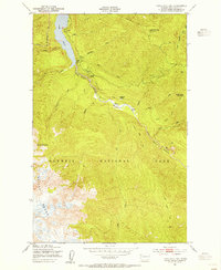
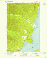
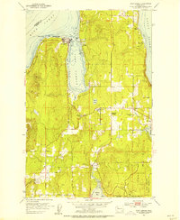
 1953 Seabeck1954 Print · USGSHood Canal and the Toandos Peninsula are seen here in the early fifties, documenting a landscape of small coastal settlements and timbered creeks. Researchers can locate Camp Parsons, the village of Coyle, and the historic Conference Grounds at Seabeck.4 unique versions available
 - 1953 Map of Poulsbo, 1954 Print
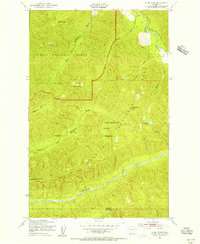
 1953 Poulsbo1954 Print · USGSKitsap County's shoreline and military landscape are frozen in time during the mid-fifties as naval operations and small-town life intersect. Genealogists and historians can trace family locations near Poulsbo Cemetery, the rail stop at Silverdale Siding, and schools like Pearson Sch.4 unique versions available
 - 1953 Map of Quilcene, 1954 Print
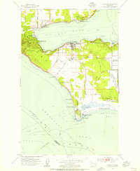
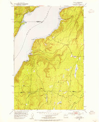
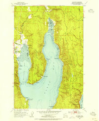 1953 Quilcene1954 Print · USGSCoastal Jefferson County comes to life in the early fifties as timber and maritime trades shaped these Olympic Peninsula shorelines. Historians can trace the development of Quilcene and East Quilcene, locating the High Sch, Bees Mill, and the State Shellfish Laboratory.4 unique versions available
 - 1953 Map of Hansville, 1954 Print
 1953 Hansville1954 Print · USGSThe northern Kitsap Peninsula and Whidbey Island are shown in the early 1950s, a period of quiet maritime life along the Admiralty Inlet. You can trace early coastal settlements like Hansville and Austin, or locate landmarks such as the Point No Point lighthouse and Cemetery.3 unique versions available
 - 1953 Map of Mt. Walker, 1955 Print
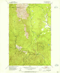 1953 Mt. Walker1955 Print · USGSJefferson County's eastern Olympic slope is captured here in the early fifties, where the town of Quilcene meets the high timber. Trace mid-century forest infrastructure and landmarks like the U S Fish Hatchery, Rainbow Camp Guard Sta, and Mt Walker.4 unique versions available
 - 1953 Map of Brinnon, 1955 Print
 1953 Brinnon1955 Print · USGSBrinnon and the Olympic Peninsula coastline are captured here in the early fifties as the region's timber and maritime identity thrived. Researchers can trace historic forest service outposts like Interrorem Guard Station, the original Brinnon School, and the winding course of the Duckabush River.5 unique versions available
 - 1953 Map of Coupeville, 1955 Print
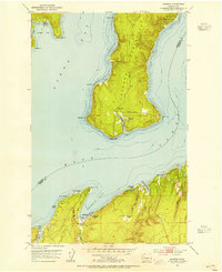
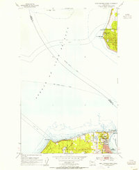
 1953 Coupeville1955 Print · USGSWhidbey Island in the early fifties shows a balance of historic prairie farming and vital Cold War military operations. Researchers can trace the legacy of Coupeville and Ebeys Landing or locate maritime landmarks like the Keystone Ferry Landing and the Lighthouse (Aband'd).3 unique versions available
 - 1953 Map of Port Gamble, 1955 Print
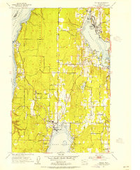
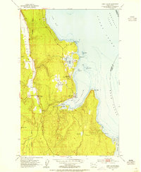
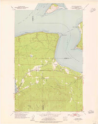
 1953 Port Gamble1955 Print · USGSThe northern Kitsap Peninsula in the early fifties shows a region defined by its timber economy and coastal settlements. Researchers can trace the layout of Port Gamble and its sawmill, find family sites at the Wolfe School, or locate land within the Port Madison Indian Reservation.5 unique versions available
 - 1953 Map of Nordland, 1955 Print
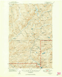
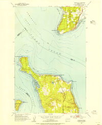
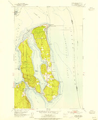 1953 Nordland1955 Print · USGSJefferson County’s coastal islands and military outposts are documented here in the early fifties, showing the area's transition into a strategic naval hub. Genealogists and researchers can locate Nordland, trace family plots at Sound View Cemetery, and explore the grounds of Fort Flagler Military Reservation.4 unique versions available
 - 1953 Map of Lofall, 1955 Print
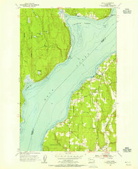 1953 Lofall1955 Print · USGSThe Hood Canal shoreline during the mid-fifties shows a landscape of ferry crossings and small coastal settlements. Researchers can trace the legacy of the Lofall Ferry, locate the Vinland Church, and find early sites like Breidablick and Standard Sch.5 unique versions available
 - 1953 Map of Center, 1955 Print
 1953 Center1955 Print · USGSThe rural Jefferson County landscape comes alive in the early fifties, showing the interplay of rail and road near the Olympic Peninsula coast. Genealogists and local historians can trace family locations near the Dabob School, the small settlement of Center, and the rail junction at Discovery Junction.3 unique versions available
 - 1953 Map of Holly, 1955 Print
 1953 Holly1955 Print · USGSThe Kitsap Peninsula in the early fifties is shown here as a quiet landscape of timber and tide. Researchers can trace remote settlements like Holly and Hintzville or locate family landmarks near Morgan Marsh and the Tahuya River.6 unique versions available
 - 1953 Map of Port Ludlow, 1955 Print
 1953 Port Ludlow1955 Print · USGSJefferson County’s shoreline in the early fifties reveals a maritime community centered on sheltered bays and timbered valleys. Researchers can locate the historic Port Ludlow Post Office and trace the roads connecting Swansonville and the Mats Mats Quarry.3 unique versions available
 - 1953 Map of Port Townsend North, 1955 Print
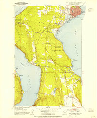
 1953 Port Townsend North1955 Print · USGSThe entrance to Puget Sound in the early fifties shows a landscape shaped by coastal defense and maritime commerce. Trace the grounds of Fort Worden Military Res, the lighthouse at Point Wilson, and the ferry lanes crossing the Strait of Juan de Fuca.3 unique versions available
 - 1953 Map of Port Townsend South, 1955 Print
 1953 Port Townsend South1955 Print · USGSThe Quimper Peninsula in the mid-1950s is a landscape of coastal industry and rural valley life. Genealogists and historians can trace the rail corridor of the Chicago Milwaukee St Paul and Pacific or locate residents near Irondale, Hadlock, and Laurel Grove Cem.4 unique versions available
 - 1953 Map of Uncas, 1955 Print
 1953 Uncas1955 Print · USGSJefferson County’s coastal forests and timber-focused rail lines are captured here in the early fifties. Local historians can trace the old Olympic P & P RR through the settlements of Uncas and Leland, or locate the Uncas Sch and Snow Creek Guard Sta.4 unique versions available
 - 1953 Map of Gardiner, 1955 Print
 1953 Gardiner1955 Print · USGSThe northern Olympic Peninsula in the early fifties shows a landscape of coastal settlements and timber-era infrastructure. Researchers can trace the Chicago Milwaukee St Paul and Pacific rail line and locate landmarks like the Cem near Blyn and Diamond Pt.5 unique versions available
Showing maps 1-25 of 38
Top cities of Jefferson County
- Port Townsend historical maps
- Port Hadlock historical maps
- Port Ludlow historical maps
- Brinnon historical maps
- Quilcene historical maps
Frequently asked questions
- What are the different types of historical maps available for Jefferson County?
- What is the oldest map of Jefferson County?
- Where can I purchase historical maps of Jefferson County for my home or office?
- Where can I download high-res historical maps of Jefferson County?
- Are there historical topographic maps available for Jefferson County?
- Is there historical aerial imagery available for Jefferson County?
- Where are historical maps of Jefferson County sourced from?