1980s Maps of Jefferson County, Washington
Explore 17 historic maps of Jefferson County from the 1980s. These maps offer a rare glimpse into what life looked like during the 1980s — showing old roads, neighborhoods, homes, and landmarks that have changed or disappeared over time.
Whether you're researching your family's past, planning a metal detecting trip, or studying how Jefferson County's landscape evolved across the 1980s, these high-resolution maps are a powerful tool for exploring the history of this region.
- Focus on a specific era: All maps on this page are from the 1980s, giving you a focused view of this time period.
- See what’s changed: Compare century-old streets, trails, and buildings to today's modern landscape using overlays and satellite layers.
- Research with precision: Use these maps for genealogy, historical research, land use analysis, or educational projects.
- View, download, or print: Maps are fully viewable online in high resolution, and can be downloaded or printed for your own records.
Start exploring Jefferson County's history through authentic maps from the 1980s. This is your window into the past.
Jefferson County, WA maps
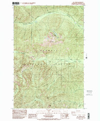
(17)- 1981 Map of Forks, 1982 Print
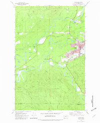 1981 Forks1982 Print · USGSThe convergence of the Soleduck River, Calawah River, and Bogachiel River defines this Olympic Peninsula town in the early eighties. Trace local landmarks like the Community Hosp, Municipal Airport, and the Old RR Grade.
 - 1981 Map of Reade Hill, 1982 Print
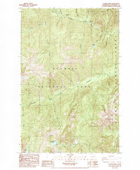
 1981 Reade Hill1982 Print · USGSThe Olympic Peninsula logging town of Forks is shown in the early eighties as it expanded into the surrounding timberlands. Genealogists and local historians can trace the early streets of Forks, the local Cem, and the recreation sites at Bogachiel State Park.
 - 1982 Map of La Push
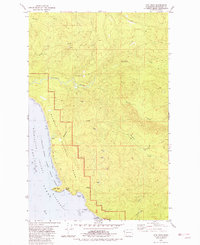
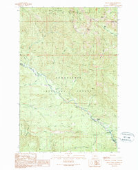
 1982 La Push1982 Print · USGSCoastal Clallam County in the early eighties shows the intersection of tribal lands and federal wilderness at the mouth of the Quillayute River. Local historians can trace the development of La Push including its US Coast Guard Station and the Chilean Memorial Monument.2 unique versions available
 - 1982 Map of Quillayute Prairie
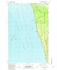
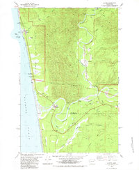
 1982 Quillayute Prairie1982 Print · USGSThe coastal Olympic Peninsula in the early eighties shows the junction of the Bogachiel and Soleduck Rivers near the Pacific Ocean. Researchers can trace the layout of the Quileute Indian Reservation, the Quillayute Cem, and the historical Mora (Site).2 unique versions available
 - 1982 Map of Toleak Point
 1982 Toleak Point1982 Print · USGSThe Olympic Peninsula coastline in the early eighties reveals a wild, marine landscape of sea stacks and rocky reefs. Trace the dramatic shoreline from Teahwhit Head past the Giants Graveyard to the mouth of Goodman Creek.
 - 1982 Map of Destruction Island
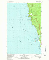
 1982 Destruction Island1982 Print · USGSThe Jefferson County coast in the early eighties shows a landscape of deep conservation and maritime isolation. Researchers can trace the Hoh Indian Reservation boundary, locate the Fletcher Cem, and see the remote Lighthouse on Destruction Island.
 - 1982 Map of Hoh Head
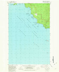
 1982 Hoh Head1982 Print · USGSThe Jefferson County coast in the early 1980s reveals a wild intersection of federal parkland and early industrial remnants. Local history enthusiasts can locate the Oil City (Site) and the Jefferson Oil Seep near the mouth of the Hoh River.2 unique versions available
 - 1982 Map of Anderson Creek
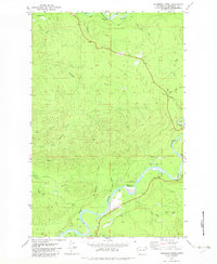 1982 Anderson Creek1982 Print · USGSJefferson County in the early eighties is captured here as a landscape of timber roads and major river systems. Genealogists and historians can trace industrial and recreational sites like the Lacy Oil Seep (Site), Cottonwood Campground, and the Upper Hoh Road.
 - 1982 Map of Kalaloch Ridge
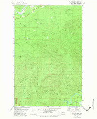 1982 Kalaloch Ridge1982 Print · USGSJefferson County's coastal timberlands and protected parklands are shown here in the early eighties. Researchers can trace the HOH RIVER and find local landmarks like Skookumchuck Rapids and the KALALOCH RIDGE high ground.
 - 1982 Map of Queets
 1982 Queets1982 Print · USGSThe Olympic Peninsula coastline and its deep river valleys come into focus in the early eighties as the modern recreational and tribal landscape takes shape. Genealogists and historians can trace the foundations of Queets and Clearwater, locating the Queets-Clearwater Sch and early campgrounds like Kalaloch.
 - 1985 Map of Eldon
 1985 Eldon1985 Print · USGSThe western shores of Hood Canal come into focus in the mid-1980s, where the Olympic foothills meet the saltwater. Researchers can trace coastal landmarks like Eldon and Ayock Point or locate the interior Hamma Hamma F S Station and its surrounding camps.
 - 1985 Map of Mt Washington
 1985 Mt Washington1985 Print · USGSThe high peaks of the Olympic range appear here in the mid-1980s, marking the rugged boundary of Mason and Jefferson counties. Trace the paths around Mt Washington, the waters of Lena Lake, and old resource sites like the Gravel Pit near the Hamma Hamma River.2 unique versions available
 - 1985 Map of Mt Jupiter
 1985 Mt Jupiter1985 Print · USGSThe eastern Olympic Peninsula reaches its high point at Mt Jupiter in the mid-1980s. Trace the paths to Jupiter Lakes, St Peters Dome, and historic river camps like Elkhorn Campground.
 - 1985 Map of The Brothers
 1985 The Brothers1985 Print · USGSThe Olympic wilderness of Jefferson County is documented here in the mid-1980s, showcasing the high-altitude interface of the national park and forest. Hikers and historians can trace traditional backcountry routes past the Dosewallips Ranger Sta to Lake Constance or The Brothers.2 unique versions available
 - 1988 Map of Mount Olympus
 1988 Mount Olympus1988 Print · USGSThe Olympic Peninsula's glacial heart is captured here in the late eighties, documenting the reach of permanent ice and river headwaters. Trace the contours of the Bailey Range and identify landmarks like Sol Duc Hot Springs and the Seven Lakes Basin.
 - 1988 Map of Forks
 1988 Forks1988 Print · USGSThe Olympic Peninsula's western coastline and timber heartland are documented here in the late eighties, from the high ridges to the Pacific shelf. Local researchers can trace the coastal settlements of La Push and Mora or locate remote sites like Destruction Island.
 - 1989 Map of Mount Christie
 1989 Mount Christie1989 Print · USGSThe high divide between the Wenatchee and Snoqualmie forests is captured in the late eighties, showing a landscape of remote ridges and vital river headwaters. You can locate backcountry landmarks like the Taneum Shelter, seasonal Mathew Meadow, and historical camping spots at Naches Pass Campsite.
End of results
Showing maps 1-17 of 17
Top cities of Jefferson County
- Port Townsend historical maps
- Port Hadlock historical maps
- Port Ludlow historical maps
- Brinnon historical maps
- Quilcene historical maps
Frequently asked questions
- What are the different types of historical maps available for Jefferson County?
- What is the oldest map of Jefferson County?
- Where can I purchase historical maps of Jefferson County for my home or office?
- Where can I download high-res historical maps of Jefferson County?
- Are there historical topographic maps available for Jefferson County?
- Is there historical aerial imagery available for Jefferson County?
- Where are historical maps of Jefferson County sourced from?