Old Maps of Long Beach, Washington for Hiking & Exploration
Hike through history with 8 historic maps of Long Beach. Explore old trails, ghost towns, and forgotten backroads — perfect for outdoor adventurers and local explorers.
- Rediscover forgotten places: Map out old mining camps, roads, and footpaths that no longer exist on modern maps.
- Layer with modern tools: Combine with LiDAR or satellite views to plan hikes through historical terrain.
- Made for exploration: Popular among hikers, overlanders, and local history lovers.
Use these maps to find adventure and explore the hidden past of Long Beach.
Long Beach, WA maps
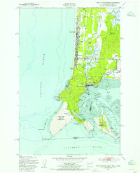
(8)- 1938 Map of Cape Disappointment
 1938 Cape Disappointment1938 Print · USGSThe Long Beach Peninsula in the late 1930s was a bustling landscape of oyster docks, coastal ranches, and military outposts. Genealogists can trace family holdings like the Loomis Ranch or find local landmarks including the Moby Dick Hotel and Fort Canby.
 - 1943 Map of Copalis Beach
 1943 Copalis Beach1943 Print · USGSThe Washington coast in the 1940s is detailed here from the Olympic Peninsula to the Columbia River. Trace old beach settlements like Moclips and Copalis Beach alongside landmarks like the Willapa Bay Lighthouse.
 - 1949 Map of Cape Disappointment, 1955 Print
 1949 Cape Disappointment1955 Print · USGSThe Washington coast at the mouth of the Columbia River comes alive in this mid-century survey of the Long Beach Peninsula. Genealogists and local historians can trace family properties like Christorf Ranch, visit the Lone Fir Cem, or locate the historic Fort Canby military grounds.4 unique versions available
 - 1951 Map of Copalis Beach
 1951 Copalis Beach1951 Print · USGSThe Olympic Peninsula's rugged coast and tribal lands are meticulously detailed in the early 1950s. Genealogists and historians can trace the foundations of coastal communities from Taholah to La Push or locate early markers like the James Island Lighthouse.
 - 1957 Map of Copalis Beach, 1968 Print
 1957 Copalis Beach1968 Print · USGSThe Washington coast during the late fifties reveals a landscape of tribal reservations and timber towns linked by the Northern Pacific RR. Trace family history and land patterns near Forks Cemetery, the shingle mill, or coastal landings like Taholah and Oysterville.2 unique versions available
 - 1963 Map of Copalis Beach
 1963 Copalis Beach1963 Print · USGSThe Washington coast in the early sixties reveals a landscape of massive timber reserves, indigenous lands, and quiet seaside villages. Genealogists and historians can trace the foundations of coastal life through sites like Lone Fir Cemetery, the Dismantled RR, and the historic oyster beds of Oysterville.
 - 1980 Map of Ilwaco, 1989 Print
 1980 Ilwaco1989 Print · USGSThe Washington-Oregon borderlands come into focus during the 1980s, revealing the coastal communities of the North Beach Peninsula and the mouth of the Columbia. Researchers can trace historical sites like Fort Canby State Park, locate the North Head Lighthouse, and explore the shoreline from Ocean Park to Ilwaco.
 - 2023 Map of Cape Disappointment, 2023 Print
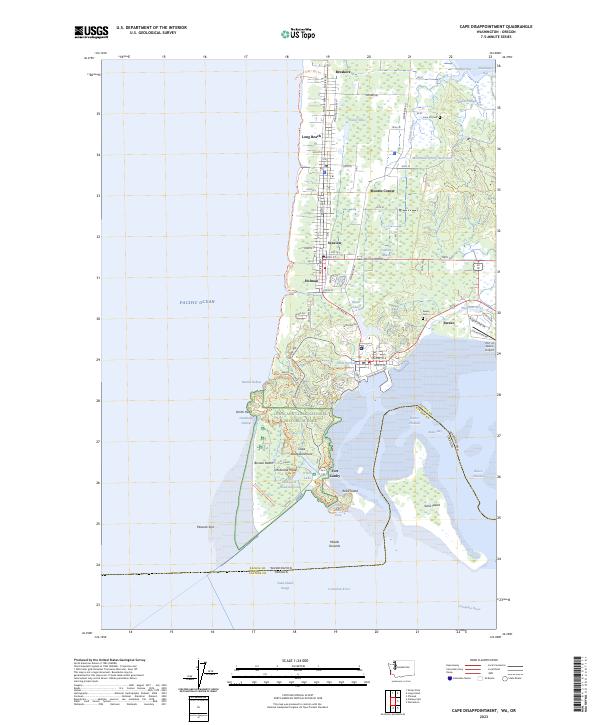 2023 Cape Disappointment2023 Print · USGSThe Long Beach Peninsula meets the Columbia River in the early 2020s, showing a landscape of maritime history and coastal settlements. Trace local heritage through the Lone Fir Cem, the grounds of Fort Canby, and the waterfront at Ilwaco.
End of results
Showing maps 1-8 of 8
Top cities near Long Beach
Top neighborhoods of Long Beach
Frequently asked questions
- What are the different types of historical maps available for Long Beach?
- What is the oldest map of Long Beach?
- Where can I purchase historical maps of Long Beach for my home or office?
- Where can I download high-res historical maps of Long Beach?
- Are there historical topographic maps available for Long Beach?
- Is there historical aerial imagery available for Long Beach?
- Where are historical maps of Long Beach sourced from?