1940s Maps of Naselle, Washington
Explore 2 historic maps of Naselle from the 1940s. These maps offer a rare glimpse into what life looked like during the 1940s — showing old roads, neighborhoods, homes, and landmarks that have changed or disappeared over time.
Whether you're researching your family's past, planning a metal detecting trip, or studying how Naselle's landscape evolved across the 1940s, these high-resolution maps are a powerful tool for exploring the history of this region.
- Focus on a specific era: All maps on this page are from the 1940s, giving you a focused view of this time period.
- See what’s changed: Compare century-old streets, trails, and buildings to today's modern landscape using overlays and satellite layers.
- Research with precision: Use these maps for genealogy, historical research, land use analysis, or educational projects.
- View, download, or print: Maps are fully viewable online in high resolution, and can be downloaded or printed for your own records.
Start exploring Naselle's history through authentic maps from the 1940s. This is your window into the past.
Naselle, WA maps
(2)- 1943 Map of Fort Columbia
 1943 Fort Columbia1943 Print · USGSThe coastal defense and river economy of Pacific County are captured here during the wartime era. Genealogists and historians can locate numerous family-named landmarks like Gile Ranch or Kyle Ranch alongside the Naselle State Salmon Hatchery and Fort Columbia.
 - 1949 Map of Knappton, 1954 Print
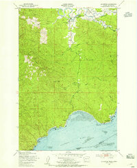 1949 Knappton1954 Print · USGSThe Columbia River shoreline and the timberlands of Pacific County are captured here just after the war. Discover the locations of the Quarantine Sta, the Old Railroad Grade, and small riverfront landings like Frankfort and Knappton.5 unique versions available
End of results
Showing maps 1-2 of 2
Top cities near Naselle
Frequently asked questions
- What are the different types of historical maps available for Naselle?
- What is the oldest map of Naselle?
- Where can I purchase historical maps of Naselle for my home or office?
- Where can I download high-res historical maps of Naselle?
- Are there historical topographic maps available for Naselle?
- Is there historical aerial imagery available for Naselle?
- Where are historical maps of Naselle sourced from?