1980s Maps of Pend Oreille County, Washington
Explore 3 historic maps of Pend Oreille County from the 1980s. These maps offer a rare glimpse into what life looked like during the 1980s — showing old roads, neighborhoods, homes, and landmarks that have changed or disappeared over time.
Whether you're researching your family's past, planning a metal detecting trip, or studying how Pend Oreille County's landscape evolved across the 1980s, these high-resolution maps are a powerful tool for exploring the history of this region.
- Focus on a specific era: All maps on this page are from the 1980s, giving you a focused view of this time period.
- See what’s changed: Compare century-old streets, trails, and buildings to today's modern landscape using overlays and satellite layers.
- Research with precision: Use these maps for genealogy, historical research, land use analysis, or educational projects.
- View, download, or print: Maps are fully viewable online in high resolution, and can be downloaded or printed for your own records.
Start exploring Pend Oreille County's history through authentic maps from the 1980s. This is your window into the past.
Pend Oreille County, WA maps
(3)- 1980 Map of Calispell Peak, 1981 Print
 1980 Calispell Peak1981 Print · USGSThe Selkirk Mountains of northeastern Washington are shown here in the early eighties, centered on the high refuge lands and peaks. Genealogists and hikers can trace family-named sites like Pal Moore Meadow and Hartill Meadows, or locate the Merikay Mine near the county line.
 - 1984 Map of Colville
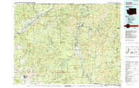 1984 Colville1984 Print · USGSNortheastern Washington and the Idaho borderlands are documented here in the mid-1980s as the regional economy balanced forestry and mineral extraction. Genealogists and researchers can trace dozens of mountain mining operations like Van Stone Mine alongside timber settlements such as Metaline Falls and Aladdin.2 unique versions available
 - 1984 Map of Chewelah
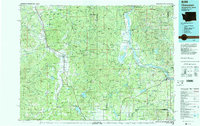 1984 Chewelah1984 Print · USGSNortheastern Washington in the mid-1980s is documented here through its valley settlements and mountain mining districts. Researchers can trace the Burlington Northern line between Springdale and Addy, or locate historical operations like the Wells Fargo Mine and Keystone Mine.
End of results
Showing maps 1-3 of 3
Top cities of Pend Oreille County
- Newport historical maps
- Ione historical maps
- Metaline Falls historical maps
- Cusick historical maps
- Metaline historical maps
Frequently asked questions
- What are the different types of historical maps available for Pend Oreille County?
- What is the oldest map of Pend Oreille County?
- Where can I purchase historical maps of Pend Oreille County for my home or office?
- Where can I download high-res historical maps of Pend Oreille County?
- Are there historical topographic maps available for Pend Oreille County?
- Is there historical aerial imagery available for Pend Oreille County?
- Where are historical maps of Pend Oreille County sourced from?