1950s Maps of DuPont, Washington
Explore 5 historic maps of DuPont from the 1950s. These maps offer a rare glimpse into what life looked like during the 1950s — showing old roads, neighborhoods, homes, and landmarks that have changed or disappeared over time.
Whether you're researching your family's past, planning a metal detecting trip, or studying how DuPont's landscape evolved across the 1950s, these high-resolution maps are a powerful tool for exploring the history of this region.
- Focus on a specific era: All maps on this page are from the 1950s, giving you a focused view of this time period.
- See what’s changed: Compare century-old streets, trails, and buildings to today's modern landscape using overlays and satellite layers.
- Research with precision: Use these maps for genealogy, historical research, land use analysis, or educational projects.
- View, download, or print: Maps are fully viewable online in high resolution, and can be downloaded or printed for your own records.
Start exploring DuPont's history through authentic maps from the 1950s. This is your window into the past.
DuPont, WA maps
(5)- 1958 Map of Seattle, 1966 Print
 1958 Seattle1966 Print · USGSThe Puget Sound region in the mid-fifties showcases a balance of urban growth and Olympic wilderness. Trace the industrial waterfronts of Tacoma, old naval facilities like Keyport Naval Res, and mountain peaks like Mount Constance.3 unique versions available
 - 1959 Map of Fort Lewis, 1966 Print
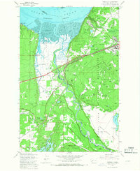
 1959 Fort Lewis1966 Print · USGSPierce County was a focal point of West Coast defense and transport in the late fifties as military installations and railroads expanded. Genealogists and historians can trace the early layout of Tillicum, the town of Roy, and massive facilities like the Mount Rainier Ordnance Depot.4 unique versions available
 - 1959 Map of Mc Neil Island, 1966 Print
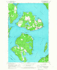 1959 Mc Neil Island1966 Print · USGSThe South Puget Sound islands appear here in the late fifties, dominated by the sprawling infrastructure of the Mc Neil Island (Federal Penitentiary). Researchers can trace historical routes like the Steilacoom Ferry or locate the Hillcrest Cem and Anderson Island Cem.5 unique versions available
 - 1959 Map of Nisqually, 1967 Print
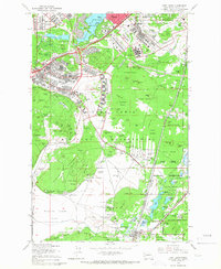
 1959 Nisqually1967 Print · USGSThe Nisqually River delta and the northern reaches of the Fort Lewis Military Reservation are captured here during a period of steady military and coastal development. Genealogists and historians can trace family-named landmarks like Foster Hill and Hoffman Hill or locate early infrastructure at Nisqually Station and Dupont.6 unique versions available
 - 1959 Map of Anderson Island, 1968 Print
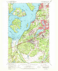 1959 Anderson Island1968 Print · USGSPierce County in the late fifties was a hub of military and institutional activity as suburban communities began to expand south of Tacoma. Trace the mid-century footprints of the Federal Penitentiary on McNeil Island, the Mount Rainier Ordnance Depot, and Lakewood Center.
End of results
Showing maps 1-5 of 5
Top cities near DuPont
- Tacoma historical maps
- Lakewood historical maps
- Olympia historical maps
- Lacey historical maps
- Parkland historical maps
- Spanaway historical maps
See more
Frequently asked questions
- What are the different types of historical maps available for DuPont?
- What is the oldest map of DuPont?
- Where can I purchase historical maps of DuPont for my home or office?
- Where can I download high-res historical maps of DuPont?
- Are there historical topographic maps available for DuPont?
- Is there historical aerial imagery available for DuPont?
- Where are historical maps of DuPont sourced from?