1950s Maps of Skagit County, Washington
Explore 21 historic maps of Skagit County from the 1950s. These maps offer a rare glimpse into what life looked like during the 1950s — showing old roads, neighborhoods, homes, and landmarks that have changed or disappeared over time.
Whether you're researching your family's past, planning a metal detecting trip, or studying how Skagit County's landscape evolved across the 1950s, these high-resolution maps are a powerful tool for exploring the history of this region.
- Focus on a specific era: All maps on this page are from the 1950s, giving you a focused view of this time period.
- See what’s changed: Compare century-old streets, trails, and buildings to today's modern landscape using overlays and satellite layers.
- Research with precision: Use these maps for genealogy, historical research, land use analysis, or educational projects.
- View, download, or print: Maps are fully viewable online in high resolution, and can be downloaded or printed for your own records.
Start exploring Skagit County's history through authentic maps from the 1950s. This is your window into the past.
Skagit County, WA maps
(21)- 1951 Map of Wickersham, 1953 Print
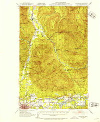 1951 Wickersham1953 Print · USGSSkagit County in the early fifties shows a landscape of river-valley industry and timber outposts along the Skagit River. Genealogists and historians can locate the Northern State Hospital, trace the Cokedale Mine, and find rural centers like Samish School.3 unique versions available
 - 1951 Map of Deception Pass, 1953 Print
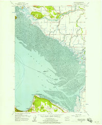
 1951 Deception Pass1953 Print · USGSWhidbey and Fidalgo Islands appear here in the early fifties as the region's naval and agricultural identities merged. Genealogists and local historians can trace early schools and coastal landmarks like Rosario School, Fort Whitman, and the village of La Conner.3 unique versions available
 - 1951 Map of Anacortes, 1953 Print
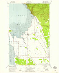
 1951 Anacortes1953 Print · USGSThe northern Puget Sound islands and the city of Anacortes are captured here in the early fifties during a period of steady coastal growth. Researchers can locate vanished landmarks and family roots at Eden Cem, Sinclair Sch, and the Lummi Indian Reservation.2 unique versions available
 - 1952 Map of Lake Whatcom, 1953 Print
 1952 Lake Whatcom1953 Print · USGSWhatcom County in the early fifties showcases a landscape of timbered peaks and vital lakeside rail lines. Genealogists and historians can trace the Northern Pacific corridor through Blue Canyon and Park, or locate the State Trout Hatchery near the shores of Lake Whatcom.4 unique versions available
 - 1952 Map of Lake Shannon, 1953 Print
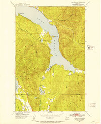
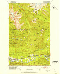
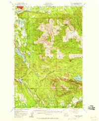
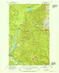 1952 Lake Shannon1953 Print · USGSSkagit County in the early fifties shows a rugged mountain landscape being transformed by hydroelectric power and the timber industry. You can trace the Great Northern rail line through Concrete or locate remote landmarks like the Morovitz Ranch and Faber Ferry.3 unique versions available
 - 1952 Map of Alger, 1954 Print
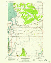
 1952 Alger1954 Print · USGSSkagit County in the early fifties shows a landscape defined by riverside settlements and rural agriculture. You can trace early community life through the Silver Run Grange, locate the Belfast Sch (Aban'd), and find the State Salmon Hatchery along Friday Creek.4 unique versions available
 - 1952 Map of Hamilton, 1954 Print
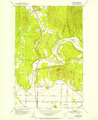
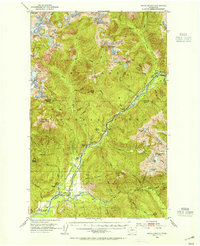
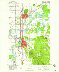
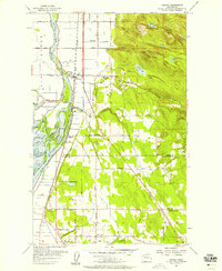
 1952 Hamilton1954 Print · USGSThe Skagit River valley was a bustling corridor of rail and river industry in the early fifties, anchored by the towns of Hamilton and Concrete. Genealogists and historians can trace the GREAT NORTHERN line through Birdsview, find the local High School, or locate the Cem and Dalles Bridge.3 unique versions available
 - 1953 Map of Marblemount, 1955 Print
 1953 Marblemount1955 Print · USGSThe Skagit River valley in the mid-fifties shows a landscape defined by hydropower logistics and the North Cascades wilderness. You can trace the City of Seattle Railway past Newhalem or locate the Skagit Talc Mine near Marblemount.3 unique versions available
 - 1954 Map of Bow, 1956 Print
 1954 Bow1956 Print · USGSCoastal Skagit County comes to life in the mid-1950s, showing the intersection of the Great Northern railroad with tidal flats and farming towns. Trace the history of Samish Island and the rural schools and stations at Edison Station and Bow.4 unique versions available
 - 1954 Map of Bellingham South, 1959 Print
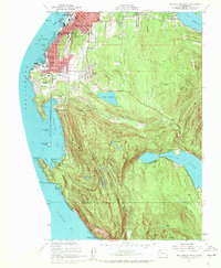 1954 Bellingham South1959 Print · USGSCoastal Whatcom County is captured mid-century as the city expands toward the wooded heights. Genealogists and historians can trace institutional roots at Western Washington College and find early school sites like Lowell School and Larrabee School.4 unique versions available
 - 1954 Map of Samish Lake, 1960 Print
 1954 Samish Lake1960 Print · USGSCoastal Skagit and Whatcom Counties are captured here in the mid-fifties as rural settlements like Garden of Eden and Blue Canyon thrived alongside the growing college town of Bellingham. Genealogists can trace family landmarks like Belfast Sch, the Silver Run Grange Hall, and the Pierson Sch.
 - 1955 Map of Concrete, 1967 Print
 1955 Concrete1967 Print · USGSThe North Cascades in the mid-fifties reveal a landscape of deep glacier-fed lakes and riverside timber towns. You can trace the Great Northern rail lines through Granite Falls or locate remote outposts like Stehekin and Marblemount along the Skagit and Chelan waters.
 - 1956 Map of Utsalady, 1957 Print
 1956 Utsalady1957 Print · USGSCoastal Skagit County and the northern tip of Camano Island are shown here in the mid-fifties during a period of steady maritime and agricultural life. Researchers can trace historic family-named routes like Maupin Road and locate the waterfront community of Utsalady or the timber-related English Boom.3 unique versions available
 - 1956 Map of Clear Lake, 1958 Print
 1956 Clear Lake1958 Print · USGSSkagit County's timber and rail corridor is captured here in the mid-fifties, from the banks of the Skagit River to the peaks of Cultus Mtn. Genealogists and historians can trace old community footprints in Sedro-Woolley, the rail-side village of McMurray, and the Old Railroad Grade near Lake Cavanaugh.3 unique versions available
 - 1956 Map of Mount Vernon, 1958 Print
 1956 Mount Vernon1958 Print · USGSSkagit County in the mid-fifties is a landscape of river-driven commerce and growing valley towns. Genealogists and historians can trace old school districts like Westview School, find the Meadow Grange, and locate vanished river crossings near Skagit City.6 unique versions available
 - 1956 Map of Oso, 1958 Print
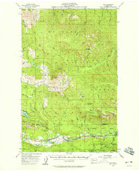 1956 Oso1958 Print · USGSThe Stillaguamish River valley and the surrounding peaks of the North Cascades come into focus during the mid-fifties. Researchers can trace the path of the Northern Pacific railroad through Oso and Hazel or locate early recreation spots like the Stillaguamish Country Club.3 unique versions available
 - 1956 Map of Conway, 1958 Print
 1956 Conway1958 Print · USGSThe Skagit River delta and the Snohomish county line appear here in the mid-fifties, showing a landscape of fertile river islands and timbered hills. Genealogists and researchers can trace the Great Northern rail line through Conway and Milltown, or locate family sites near Freeborn Church and the Cedarhome settlement.4 unique versions available
 - 1956 Map of La Conner, 1958 Print
 1956 La Conner1958 Print · USGSSkagit County coastal life in the mid-fifties is defined by the labyrinthine waterways between La Conner and Bay View. Researchers can trace old schools like Harmony Sch (Aband) and landmarks such as the Pioneer Monument and Mount Vernon Airport.4 unique versions available
 - 1957 Map of Orcas Island, 1959 Print
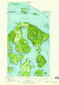 1957 Orcas Island1959 Print · USGSThe San Juan Islands are shown here in the late fifties, a time when coastal settlements and island retreats defined the archipelago. Genealogists and historians can trace old community centers like Griswold, Doe Bay, and the early layout of Moran State Park.2 unique versions available
 - 1957 Map of Victoria, 1960 Print
 1957 Victoria1960 Print · USGSThe San Juan Islands and the North Cascades coastline are shown in detail during the late fifties, a period of significant military and industrial presence. Researchers can trace historic rail lines like the Great Northern or locate sites such as the Whidbey Island Naval Air Sta and Friday Harbor.4 unique versions available
 - 1958 Map of Concrete
 1958 Concrete1958 Print · USGSThe North Cascades and Skagit Valley are captured here in the late fifties, showing a landscape defined by glacier-carved peaks and river-bottom settlements. Genealogists and historians can locate remote mining sites like Holden Mine and mountain outposts such as Stehekin, Marblemount, and Mazama.2 unique versions available
End of results
Showing maps 1-21 of 21
Top cities of Skagit County
- Mount Vernon historical maps
- Anacortes historical maps
- Sedro-Woolley historical maps
- Burlington historical maps
- La Conner historical maps
Frequently asked questions
- What are the different types of historical maps available for Skagit County?
- What is the oldest map of Skagit County?
- Where can I purchase historical maps of Skagit County for my home or office?
- Where can I download high-res historical maps of Skagit County?
- Are there historical topographic maps available for Skagit County?
- Is there historical aerial imagery available for Skagit County?
- Where are historical maps of Skagit County sourced from?