1970s Maps of Skagit County, Washington
Explore 12 historic maps of Skagit County from the 1970s. These maps offer a rare glimpse into what life looked like during the 1970s — showing old roads, neighborhoods, homes, and landmarks that have changed or disappeared over time.
Whether you're researching your family's past, planning a metal detecting trip, or studying how Skagit County's landscape evolved across the 1970s, these high-resolution maps are a powerful tool for exploring the history of this region.
- Focus on a specific era: All maps on this page are from the 1970s, giving you a focused view of this time period.
- See what’s changed: Compare century-old streets, trails, and buildings to today's modern landscape using overlays and satellite layers.
- Research with precision: Use these maps for genealogy, historical research, land use analysis, or educational projects.
- View, download, or print: Maps are fully viewable online in high resolution, and can be downloaded or printed for your own records.
Start exploring Skagit County's history through authentic maps from the 1970s. This is your window into the past.
Skagit County, WA maps
(12)- 1973 Map of Hamilton, 1974 Print
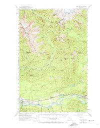 1973 Hamilton1974 Print · USGSThe Skagit River valley in the early fifties shows a bustling industrial corridor shaped by rail and timber. Researchers can trace the Northern Great Railway through Hamilton, find the old High School in Concrete, or locate the Birdsview Siding.2 unique versions available
 - 1973 Map of Cypress Island, 1977 Print
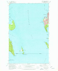
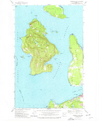 1973 Cypress Island1977 Print · USGSThe northern San Juan Islands are captured in the early 1970s, from the rugged interior of Cypress Island to the growing docks of Anacortes. Researchers can trace the layout of small settlements like Urban and Indian Village or locate local landmarks such as Eden Cem and the Sinclair Island Light.2 unique versions available
 - 1973 Map of Anacortes North, 1977 Print
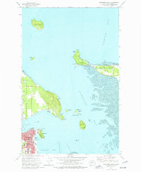 1973 Anacortes North1977 Print · USGSCoastal Skagit County appears in the early 1970s as a landscape of interconnected islands, bays, and growing maritime infrastructure. Genealogists and local historians can trace the roads of Guemes Island, find Eden Cem, and explore the northern reaches of Anacortes near Cap Sante.3 unique versions available
 - 1973 Map of Blakely Island, 1977 Print
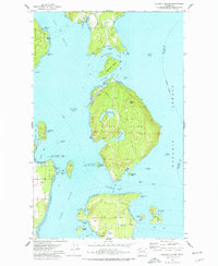 1973 Blakely Island1977 Print · USGSThe central San Juan Islands come into focus in the early seventies, showing a maritime landscape of isolated settlements and protected wilderness. Local historians can trace the early footprints of Thatcher and Decatur, alongside landmarks like Blakely Peak and Spencer Spit State Park.3 unique versions available
 - 1975 Map of Bellingham, 1977 Print
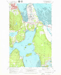
 1975 Bellingham1977 Print · USGSNorthwest Washington in the mid-seventies is captured here, from the Canadian border at Blaine to the San Juan Islands. Researchers can trace tribal lands on the Lummi Indian Reservation, find rural settlements like Cokedale, or follow the Burlington Northern rail lines.
 - 1975 Map of Port Townsend, 1977 Print
 1975 Port Townsend1977 Print · USGSThe northern Puget Sound in the mid-seventies shows a landscape of military readiness and maritime industry. Researchers can trace the extensive Whidbey Island Naval Air Station or locate historic coastal defenses at Fort Casey Military Res and Fort Ebey Military Res.
 - 1977 Map of Eliza Island
 1977 Eliza Island1977 Print · USGSThe Bellingham waterfront and neighboring islands are captured in the late seventies as the city expanded southward. Researchers can trace the Burlington Northern tracks along the coast and locate local landmarks like Fairhaven Middle Sch and the secluded shoreline of Eliza Island.2 unique versions available
 - 1977 Map of Crescent Harbor, 1978 Print
 1977 Crescent Harbor1978 Print · USGSWhidbey Island and the northern tip of Camano Island are shown during the late seventies, a time of significant naval presence and rural development. Researchers can trace land use through family-named routes like Elstad Way and locate the sprawling U S Naval Air Station and Maple Grove Beach.3 unique versions available
 - 1978 Map of Lummi Island
 1978 Lummi Island1978 Print · USGSLummi Island and the surrounding waters of the Rosario Strait are captured in the late seventies, showing a landscape of coastal settlements and rugged topography. Researchers can trace land use through the Loganita Lodge grounds, the Cem near Lovers Bluff, and the tidal flats of The Portage.2 unique versions available
 - 1978 Map of Anacortes South, 1979 Print
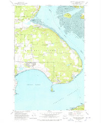
 1978 Anacortes South1979 Print · USGSSkagit County's coastal landscape appears in transition during the late seventies, balancing heavy industry with island recreation. Researchers can trace the boundaries of the Swinomish Ind Res Bdy and locate local landmarks like Summit Hall, Fidalgo Sch, and the Drive-in Theater.3 unique versions available
 - 1978 Map of Deception Pass, 1986 Print
 1978 Deception Pass1986 Print · USGSThe islands of Fidalgo and Whidbey meet at the turbulent waters of Deception Pass during the late seventies. Researchers can trace local landmarks like the Cemetery, Mt Erie, and the coastal Coast Guard Res.
 - 1979 Map of Mt. Baker, 1980 Print
 1979 Mt. Baker1980 Print · USGSThe North Cascades in the late 1970s are defined here by high-altitude glaciers and the industrial river valleys of the Skagit. Researchers can trace the rail corridors of the Burlington Northern Railroad and locate mining history at Red Mountain Mine and Silver Lake Mine.
End of results
Showing maps 1-12 of 12
Top cities of Skagit County
- Mount Vernon historical maps
- Anacortes historical maps
- Sedro-Woolley historical maps
- Burlington historical maps
- La Conner historical maps
Frequently asked questions
- What are the different types of historical maps available for Skagit County?
- What is the oldest map of Skagit County?
- Where can I purchase historical maps of Skagit County for my home or office?
- Where can I download high-res historical maps of Skagit County?
- Are there historical topographic maps available for Skagit County?
- Is there historical aerial imagery available for Skagit County?
- Where are historical maps of Skagit County sourced from?