1960s Maps of Skagit County, Washington
Explore 24 historic maps of Skagit County from the 1960s. These maps offer a rare glimpse into what life looked like during the 1960s — showing old roads, neighborhoods, homes, and landmarks that have changed or disappeared over time.
Whether you're researching your family's past, planning a metal detecting trip, or studying how Skagit County's landscape evolved across the 1960s, these high-resolution maps are a powerful tool for exploring the history of this region.
- Focus on a specific era: All maps on this page are from the 1960s, giving you a focused view of this time period.
- See what’s changed: Compare century-old streets, trails, and buildings to today's modern landscape using overlays and satellite layers.
- Research with precision: Use these maps for genealogy, historical research, land use analysis, or educational projects.
- View, download, or print: Maps are fully viewable online in high resolution, and can be downloaded or printed for your own records.
Start exploring Skagit County's history through authentic maps from the 1960s. This is your window into the past.
Skagit County, WA maps
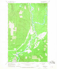
(24)- 1962 Map of Concrete
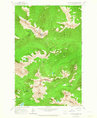
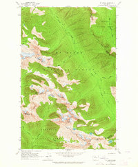
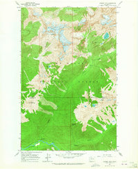
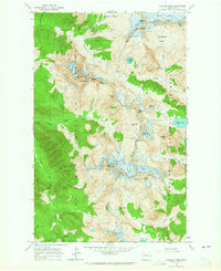
 1962 Concrete1962 Print · USGSThe Northern Cascades in the early sixties reveal a landscape of high alpine peaks and deep river valleys before the modern park era. Genealogists and historians can trace rail-and-river towns like Concrete, Darrington, and Stehekin, alongside industry at the Holden Mine.
 - 1963 Map of Washington Pass, 1964 Print
 1963 Washington Pass1964 Print · USGSHigh Cascades mountain passes and national forest boundaries appear in detail during the early 1960s. Hikers and historians can trace the early Cascade Crest Trail (Alternate) and Early Winters Trail past Liberty Bell Mtn and Washington Pass.3 unique versions available
 - 1963 Map of Azurite Peak, 1964 Print
 1963 Azurite Peak1964 Print · USGSThe North Cascades high country appears in the early sixties at a peak of alpine mining and forest management. Geologists and historians can trace the foundations of the Azurite Mine, the Gold Hill Mine, and the route of the Cascade Crest Trail.2 unique versions available
 - 1963 Map of Slate Peak, 1964 Print
 1963 Slate Peak1964 Print · USGSThe high Cascades of Okanogan County are captured here during the early 1960s, showcasing a landscape of remote mines and forest service outposts. Genealogists and researchers can locate historic mining sites like Goat Mine and base camps such as Deer Park Camp or Harts Pass Guard Station.4 unique versions available
 - 1963 Map of Sonny Boy Lakes, 1964 Print
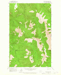
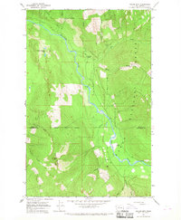
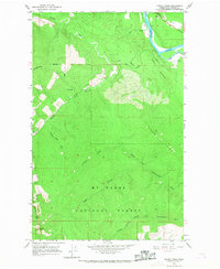
 1963 Sonny Boy Lakes1964 Print · USGSSkagit County's high wilderness is captured here in the early sixties as a network of glacial lakes and alpine ridges. You can trace the path of Cascade River Road to the Hidden Lake Lookout and the Sonny Boy Lakes.3 unique versions available
 - 1963 Map of Mt. Arriva, 1964 Print
 1963 Mt. Arriva1964 Print · USGSThe high Cascade crest at the Skagit and Okanogan county lines is documented here in the early sixties. Hikers and historians can trace the original Cascade Crest Trail as it passes Silent Lakes and the Lewis Glacier.3 unique versions available
 - 1963 Map of Eldorado Peak, 1965 Print
 1963 Eldorado Peak1965 Print · USGSSkagit County's high alpine wilderness is captured here in the early sixties, showing a landscape defined by expansive ice fields and isolated mineral prospects. You can trace the Hidden Lake Trail or locate the historic Crescent Mine among landmarks like Dorado Needle.4 unique versions available
 - 1963 Map of Forbidden Peak, 1965 Print
 1963 Forbidden Peak1965 Print · USGSThe high Cascades of Skagit County are shown here in the early sixties, a landscape of massive ice fields and isolated mining claims. Researchers can trace historic routes like the Thunder Creek Trail to the Skagit Queen Mine and old shelters at Middle Cabin.4 unique versions available
 - 1963 Map of Mt Logan, 1965 Print
 1963 Mt Logan1965 Print · USGSThe high North Cascades appear in the early sixties as a wilderness of ice and rock along the Skagit and Chelan county lines. Hikers and historians can trace the original path of the Cascade Crest Trail past Mt Logan and the sprawling Douglas Glacier.3 unique versions available
 - 1963 Map of Downey Mtn, 1965 Print
 1963 Downey Mtn1965 Print · USGSThe high Cascades at the Skagit and Snohomish county line come into focus in the early sixties. Hikers and historians can trace the remote network of Sulphur Hot Springs, the Lookout on Green Mountain, and primitive shelters like Sixmile Shelter.3 unique versions available
 - 1963 Map of Crater Mountain, 1965 Print
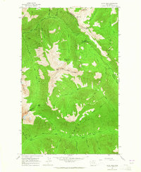
 1963 Crater Mountain1965 Print · USGSThe North Cascades in the early sixties are documented here through high-altitude topography and vital forest infrastructure. You can trace the Cascade Crest Trail past the Granite Creek Guard Station or locate remote lookouts atop Crater Mountain.2 unique versions available
 - 1963 Map of Dome Peak, 1965 Print
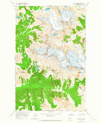 1963 Dome Peak1965 Print · USGSThe high Cascades of the early sixties are captured here at the junction of three counties, where massive glaciers dominate the divide. Outdoor historians and geologists can trace the mid-century extent of the South Cascade Glacier and Dana Glacier near prominent summits like Dome Peak.3 unique versions available
 - 1963 Map of Diablo Dam, 1965 Print
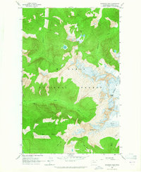
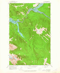
 1963 Diablo Dam1965 Print · USGSHydro-electric development in the North Cascades reached a peak in the early sixties as industrial outposts like Diablo and Newhalem hummed with activity. Trace the infrastructure of the Skagit River project from the Diablo Dam to the ice of the Neve Glacier.3 unique versions available
 - 1963 Map of Ross Dam, 1965 Print
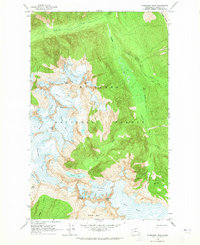
 1963 Ross Dam1965 Print · USGSThe Skagit River canyon was undergoing significant transformation in the 1960s as these massive hydroelectric projects matured within the North Cascades. Researchers can trace the early infrastructure of Ross Dam and locate seasonal landmarks like Diablo Lake Resort, Buster Brown Flats, and the Ross Lake Guard Station.4 unique versions available
 - 1963 Map of Cascade Pass, 1965 Print
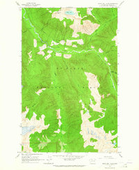
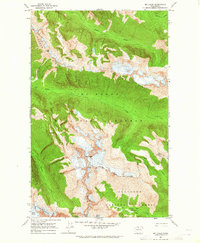
 1963 Cascade Pass1965 Print · USGSThe high North Cascades reached an era of detailed documentation in the early sixties, capturing the glaciated divide between Skagit and Chelan counties. Researchers can locate remote mining sites like the Diamond Mine or trace the drainages of Doubtful Lake and Horseshoe Basin.4 unique versions available
 - 1963 Map of Goode Mtn, 1970 Print
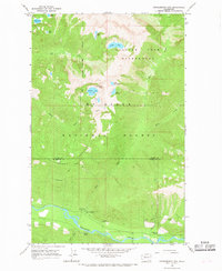
 1963 Goode Mtn1970 Print · USGSThe High Cascades near the Chelan and Skagit county line were still a remote wilderness of ice and granite in the early sixties. Hikers and historians can trace high-country routes like the Park Creek Trail past Cottonwood Camp and the icy heights of Goode Mtn.3 unique versions available
 - 1966 Map of Snowking Mtn.
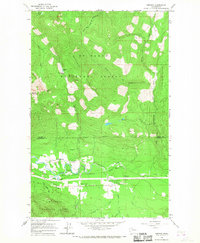
 1966 Snowking Mtn.1966 Print · USGSSkagit County’s high wilderness is documented here during the mid-sixties, showing a landscape of unnamed ridges and named alpine basins. Researchers can trace the drainages of Illabot Creek and locate remote water bodies like Snowking Lake and Bear Lake.3 unique versions available
 - 1966 Map of Huckleberry Mtn, 1968 Print
 1966 Huckleberry Mtn1968 Print · USGSThe high Cascades at the Skagit and Snohomish county line come into focus in the mid-1960s, showing a landscape defined by forest management and alpine lakes. Hikers and historians can trace the Huckleberry Trail and locate the Suiattle Guard Station and Buck Creek Campground.3 unique versions available
 - 1966 Map of Darrington, 1968 Print
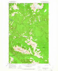
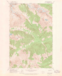
 1966 Darrington1968 Print · USGSThe Sauk and Suiattle river valleys appear in the mid-sixties as vital hubs for the timber and rail industries. Researchers can trace the Northern Pacific rail line to its terminus at Darrington or locate the Indian Cem and Three Rivers Mill Pond.4 unique versions available
 - 1966 Map of Prairie Mtn., 1968 Print
 1966 Prairie Mtn.1968 Print · USGSThe Skagit and Snohomish county line area comes into focus in the mid-sixties, showing a landscape shaped by glacial waters and mountain timber. Genealogists and historians can locate the Suiattle Cemetery and trace the paths of Big Creek and the Suiattle River.2 unique versions available
 - 1966 Map of Fortson, 1968 Print
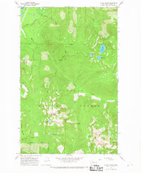
 1966 Fortson1968 Print · USGSThe Stillaguamish River valley in the mid-1960s shows a landscape of mountain rail towns and National Forest timberland. Genealogists and hikers can locate Fortson, Swede Heaven, and the old Northern Pacific rail line.3 unique versions available
 - 1966 Map of Illabot Peaks, 1968 Print
 1966 Illabot Peaks1968 Print · USGSThe high country of the North Cascades comes into focus during the mid-sixties, showing the intricate drainages of the Mt Baker National Forest. Trace the paths to alpine waters like Lake Louise, Bee Lake, and the remote Bettys Pass.4 unique versions available
 - 1966 Map of Finney Peak, 1968 Print
 1966 Finney Peak1968 Print · USGSThe Skagit and Stillaguamish river systems meet at the high ridges of the Cascades during the mid-1960s. Trace the mountain geography of Finney Peak and find early forest landmarks like the Finney Creek Shelter or Sutter Road.3 unique versions available
 - 1966 Map of Rockport, 1968 Print
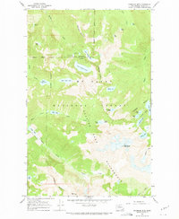
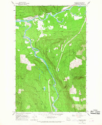 1966 Rockport1968 Print · USGSSkagit County in the mid-1960s was a landscape defined by the confluence of major rivers and the logging and ranching traditions of the North Cascades. Researchers can trace historic river access at Mc Leod Slough or locate the Cem and Hidden Valley Ranch near the town of Rockport.2 unique versions available
End of results
Showing maps 1-24 of 24
Top cities of Skagit County
- Mount Vernon historical maps
- Anacortes historical maps
- Sedro-Woolley historical maps
- Burlington historical maps
- La Conner historical maps
Frequently asked questions
- What are the different types of historical maps available for Skagit County?
- What is the oldest map of Skagit County?
- Where can I purchase historical maps of Skagit County for my home or office?
- Where can I download high-res historical maps of Skagit County?
- Are there historical topographic maps available for Skagit County?
- Is there historical aerial imagery available for Skagit County?
- Where are historical maps of Skagit County sourced from?