1990s Maps of Skagit County, Washington
Explore 25 historic maps of Skagit County from the 1990s. These maps offer a rare glimpse into what life looked like during the 1990s — showing old roads, neighborhoods, homes, and landmarks that have changed or disappeared over time.
Whether you're researching your family's past, planning a metal detecting trip, or studying how Skagit County's landscape evolved across the 1990s, these high-resolution maps are a powerful tool for exploring the history of this region.
- Focus on a specific era: All maps on this page are from the 1990s, giving you a focused view of this time period.
- See what’s changed: Compare century-old streets, trails, and buildings to today's modern landscape using overlays and satellite layers.
- Research with precision: Use these maps for genealogy, historical research, land use analysis, or educational projects.
- View, download, or print: Maps are fully viewable online in high resolution, and can be downloaded or printed for your own records.
Start exploring Skagit County's history through authentic maps from the 1990s. This is your window into the past.
Skagit County, WA maps
(25)- 1993 Map of Port Townsend
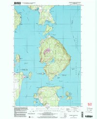
 1993 Port Townsend1993 Print · USGSThe Puget Sound and Whidbey Island are captured in the early nineties, showing a landscape defined by naval aviation and maritime trade. Genealogists and local historians can trace the development of Oak Harbor and Coupeville or locate family sites near the Arlington Municipal Cemetery and Ault Field.
 - 1997 Map of Blakely Island, 2003 Print
 1997 Blakely Island2003 Print · USGSThe San Juan archipelago comes alive in the late nineties, showing the maritime networks and island settlements of the era. Genealogists and researchers can trace family landmarks and remote outposts at Thatcher, Olga, and Decatur.
 - 1997 Map of Cypress Island, 2003 Print
 1997 Cypress Island2003 Print · USGSThe northern Puget Sound islands are frozen in time just before the turn of the millennium, showing a maritime landscape of isolated island settlements and coastal hubs. Trace family history and local landmarks from the Eden Cem on Guemes Island to the small community of Urban on Sinclair Island.
 - 1998 Map of Deception Pass, 2002 Print
 1998 Deception Pass2002 Print · USGSThe northern tip of Whidbey Island meets Fidalgo Island in the late nineties, documenting the critical maritime junction of Deception Pass. Trace the local geography from the peak of Mt Erie to the residential streets of Anacortes and Rosario Beach.
 - 1998 Map of Crescent Harbor, 2002 Print
 1998 Crescent Harbor2002 Print · USGSNorthern Whidbey Island appears here at the close of the century, centered on the strategic waterfront. Trace the footprint of Whidbey Island Naval Air Station and coastal landmarks like Strawberry Point and Maple Grove Beach.
 - 1998 Map of Anacortes South, 2002 Print
 1998 Anacortes South2002 Print · USGSFidalgo Island's maritime and industrial landscape is captured in the late nineties, from the refineries of Anacortes to the waters of Skagit Bay. Trace local family roots at Fern Hill Cem or study the shoreline near Gibraltar and Kiket Island.
 - 1998 Map of La Conner, 2002 Print
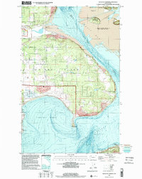
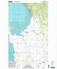
 1998 La Conner2002 Print · USGSSkagit County’s delta lands and waterfront communities are captured here in the late twentieth century. Genealogists and historians can trace family-named landmarks and rural hubs from La Conner to Fredonia, including the Pioneer Monument and Grange Hall.
 - 1998 Map of Mount Vernon, 2002 Print
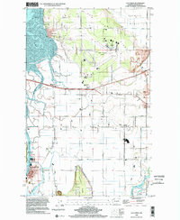
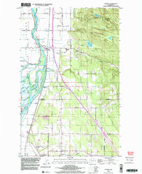
 1998 Mount Vernon2002 Print · USGSThe Skagit River valley at the close of the millennium shows the growing footprints of Mount Vernon and Burlington. Researchers can trace the Old Railroad Grade, locate Skagit Valley College, or find family landmarks like Meadow Grange and Skagit City.
 - 1998 Map of Anacortes North, 2003 Print
 1998 Anacortes North2003 Print · USGSThe northern waters of the Skagit coast come into focus in the late nineties, documenting the maritime community where the Salish Sea inlets meet. Trace family history and coastal landmarks from the Eden Cem on Guemes Island to the W T Preston Museum in Anacortes.
 - 1998 Map of Eliza Island, 2003 Print
 1998 Eliza Island2003 Print · USGSBellingham's southern waterfront and the surrounding San Juan islands are captured here in the late 1990s as coastal development met environmental conservation. Trace the streets of Fairhaven and Edgemoor or locate landmarks like Fairhaven Middle Sch and Eliza Island.
 - 1998 Map of Bellingham South, 2003 Print
 1998 Bellingham South2003 Print · USGSCoastal Bellingham and the high ridgelines of the Chuckanut Mountains meet here during the late nineties. Researchers can trace local development from the Larrabee School and Bayview Cemetery to the shores of Lake Samish and Chuckanut Village.
 - 1998 Map of Conway, 2003 Print
 1998 Conway2003 Print · USGSThe Skagit River delta and Snohomish County line are captured here in the late 1990s as agriculture and industry meet the foothills. Researchers can trace the intricate network of Steamboat Slough, locate the Conway Sch, or find family sites near Milltown and Freeborn Church.
 - 1998 Map of Lummi Island, 2003 Print
 1998 Lummi Island2003 Print · USGSNorthern Puget Sound waters meet at Lummi Island in the late nineties, documenting a landscape of tribal lands and coastal retreats. Researchers can trace land use through the Lummi Indian Reservation, find Loganita Lodge, and locate the old Cem near Legoe Bay.
 - 1998 Map of Stimson Hill, 2003 Print
 1998 Stimson Hill2003 Print · USGSSkagit and Snohomish counties meet along this timbered ridgeline in the late nineties, where the valley floor transitions into the high Cascades. Researchers can trace the rural layout of Cicero and Crane or locate old industrial sites like the Quarry and Borrow Pit.
 - 1998 Map of Bow, 2003 Print
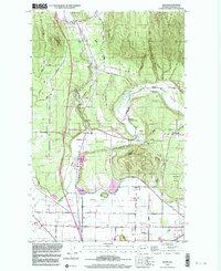
 1998 Bow2003 Print · USGSCoastal Skagit County near the close of the twentieth century shows a landscape of reclaimed tidelands and mountain foothills. Genealogists and local historians can trace family-named roads like Persons Road and locate rural hubs like Edison and the Edison Station.
 - 1998 Map of Alger, 2003 Print
 1998 Alger2003 Print · USGSSkagit County's foothills and river valleys are captured here at the close of the century, showing a transition from timbered slopes to agricultural prairies. Researchers can trace rural life through the Silver Run Grange, Belfast, and the State Salmon Hatchery.
 - 1998 Map of Utsalady, 2003 Print
 1998 Utsalady2003 Print · USGSThe Skagit River delta meets the Salish Sea in the late nineties, showing a landscape of fertile islands and tidal flats. Genealogists and historians can trace coastal settlements like Utsalady and Fish Town, or the historic timber site at English Boom near Utsalady Pt.
 - 1999 Map of Cascade Pass, 2002 Print
 1999 Cascade Pass2002 Print · USGSThe Skagit and Chelan county border in the late nineties is a landscape of glacial ice and high-altitude mining claims. Researchers can trace the path to the Diamond Mine or locate alpine landmarks like Doubtful Lake and Cascade Pass.
 - 1999 Map of Big Devil Peak, 2002 Print
 1999 Big Devil Peak2002 Print · USGSThe Skagit and Cascade river drainages are captured here at the turn of the millennium, showing a wilderness managed by three different federal agencies. Trace the remote terrain surrounding Big Devil Peak and Lookout Mountain or locate the site of the prospect and Marble Creek Campground.
 - 1999 Map of Illabot Peaks, 2002 Print
 1999 Illabot Peaks2002 Print · USGSThe North Cascades high country appears in detailed relief at the end of the century, showing the intersection of wilderness and timber lands. Researchers can trace remote alpine landmarks like Bettys Pass, the Skagit River corridor, and isolated waters such as Lake Louise.
 - 1999 Map of Damnation Peak, 2002 Print
 1999 Damnation Peak2002 Print · USGSThe Skagit and Whatcom county highlands are shown at the close of the twentieth century, dominated by federally protected wilderness. Hikers and cartographic researchers can trace the high-elevation drainages of Bacon Creek and locate remote summits like Mount Despair and Damnation Peak.
 - 1999 Map of Eldorado Peak, 2002 Print
 1999 Eldorado Peak2002 Print · USGSThe high North Cascades reached a point of meticulous conservation and study in the late nineties, as seen in this detailed survey of the Skagit high country. Mountaineers and historians can trace the extent of the Eldorado Glacier, locate the Crescent Mine, and explore the high-water basins of Hidden Lake and Wilcox Lakes.
 - 1999 Map of Bacon Peak, 2002 Print
 1999 Bacon Peak2002 Print · USGSThe high Cascades of Whatcom and Skagit counties are captured here at the close of the twentieth century. Researchers can trace the protected boundaries of the Noisy Diobsud Wilderness and locate remote features like Edgar Lake and Bacon Peak.
 - 1999 Map of Dome Peak, 2002 Print
 1999 Dome Peak2002 Print · USGSThe North Cascades high country at the close of the twentieth century reveals a landscape defined by ice and altitude. Mountaineers and researchers can trace the margins of the South Cascade Glacier and find remote landmarks like Itswoot Lake and Sinister Peak.
 - 1999 Map of Mount Triumph, 2002 Print
 1999 Mount Triumph2002 Print · USGSNewhalem and the Skagit River corridor are captured here just before the millennium, showcasing the intersection of three major federal land preserves. Researchers can trace the Thornton Lakes Trail up to Trappers Peak or locate riverside landmarks like the North Cascades Visitor Center.
End of results
Showing maps 1-25 of 25
Top cities of Skagit County
- Mount Vernon historical maps
- Anacortes historical maps
- Sedro-Woolley historical maps
- Burlington historical maps
- La Conner historical maps
Frequently asked questions
- What are the different types of historical maps available for Skagit County?
- What is the oldest map of Skagit County?
- Where can I purchase historical maps of Skagit County for my home or office?
- Where can I download high-res historical maps of Skagit County?
- Are there historical topographic maps available for Skagit County?
- Is there historical aerial imagery available for Skagit County?
- Where are historical maps of Skagit County sourced from?