1980s Maps of Skagit County, Washington
Explore 24 historic maps of Skagit County from the 1980s. These maps offer a rare glimpse into what life looked like during the 1980s — showing old roads, neighborhoods, homes, and landmarks that have changed or disappeared over time.
Whether you're researching your family's past, planning a metal detecting trip, or studying how Skagit County's landscape evolved across the 1980s, these high-resolution maps are a powerful tool for exploring the history of this region.
- Focus on a specific era: All maps on this page are from the 1980s, giving you a focused view of this time period.
- See what’s changed: Compare century-old streets, trails, and buildings to today's modern landscape using overlays and satellite layers.
- Research with precision: Use these maps for genealogy, historical research, land use analysis, or educational projects.
- View, download, or print: Maps are fully viewable online in high resolution, and can be downloaded or printed for your own records.
Start exploring Skagit County's history through authentic maps from the 1980s. This is your window into the past.
Skagit County, WA maps
(24)- 1980 Map of Lyman
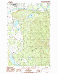
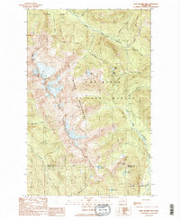
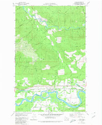 1980 Lyman1980 Print · USGSSkagit County’s timber and rail corridor comes alive in this late-century study of the river valley. Genealogists and local historians can trace family-named landmarks and infrastructure from the Hamilton Cemetery to the Lyman Ferry (Site).2 unique versions available
 - 1980 Map of Cavanaugh Creek
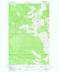 1980 Cavanaugh Creek1980 Print · USGSThe wilderness of the Whatcom and Skagit county line is captured in the late 1970s, showing a landscape defined by timber and forest service access. Trace the remote reaches of Skookum Creek, find high-country landmarks like Dailey Prairie, and follow old pack trails through the Mt Baker National Forest.2 unique versions available
 - 1980 Map of Acme, 1992 Print
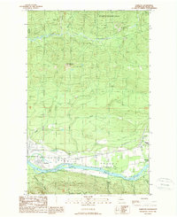
 1980 Acme1992 Print · USGSThe South Fork Nooksack River valley is shown during the early 1980s, documenting the corridor between Whatcom and Skagit counties. Researchers can trace the legacy of logging and rail at Wickersham, Mirror Lake Siding, and the Saxon Cem.2 unique versions available
 - 1981 Map of Sedro-Woolley North
 1981 Sedro-Woolley North1981 Print · USGSThe Skagit Valley and the foothills of the Cascades come alive in this early 1980s look at the region's development. Researchers can trace the sprawling grounds of the Northern State Hospital, locate the historic Cokedale Mine, and explore the rail-linked streets of Sedro-Woolley.2 unique versions available
 - 1985 Map of Mc Murray
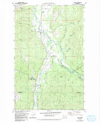
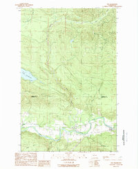
 1985 Mc Murray1985 Print · USGSSkagit and Snohomish counties are captured here in the mid-1980s, showcasing a landscape of timber-country heritage and active water systems. Researchers can trace the Old Railroad Grade through the valley or locate local landmarks like Mc Murray and the Walker Valley Quarry.
 - 1985 Map of Haystack Mtn
 1985 Haystack Mtn1985 Print · USGSThe Skagit Valley and Cultus Mountains are captured here in the mid-1980s, showing a landscape defined by timber and mineral extraction. Researchers can trace old forest roads to high-country landmarks like Haystack Mtn, Dixie Lake, and the remote Day Creek settlement.
 - 1985 Map of Stimson Hill
 1985 Stimson Hill1985 Print · USGSThe foothills of the North Cascades come into focus during the mid-eighties as industry meets the high country. Trace the river geography near Cicero and identify landmarks like Lake Cavanaugh, Stimson Hill, and the local Quarry.
 - 1985 Map of Sedro-Woolley South
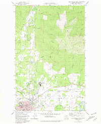
 1985 Sedro-Woolley South1985 Print · USGSSkagit County's valley floor and mountain foothills are captured here in the mid-eighties, showing the transition from the river to the high timber. Genealogists and historians can trace the lakeside communities of Big Lake and Montborne or locate old industrial sites like the Quarry.2 unique versions available
 - 1989 Map of Sauk Mountain
 1989 Sauk Mountain1989 Print · USGSSkagit County is captured in the late twentieth century as a landscape of high alpine peaks and protected wilderness. Trace the industrial history along the valley floor near an Old RR Grade or explore the heights of Sauk Mountain and the shores of Sauk Lake.
 - 1989 Map of Hamilton
 1989 Hamilton1989 Print · USGSSkagit County in the late eighties reveals a landscape of river-dependent settlements and industrial corridors along the Skagit Valley. Genealogists and historians can locate a local Cem, the Birdsview Siding rail feature, and landmarks like Marietta Falls and Careys Lake.
 - 1989 Map of Gee Point
 1989 Gee Point1989 Print · USGSThe high country of the North Cascades in the late 1980s is dominated by the steep slopes of Gee Point and Mt Baker National Forest. Researchers can trace remote mountain drainages like Finney Creek and find secluded alpine waters at Gee Point Lake.
 - 1989 Map of Lake Shannon
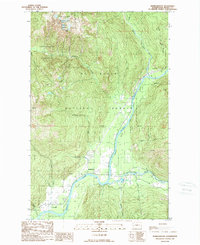
 1989 Lake Shannon1989 Print · USGSUpper Skagit County in the late 1980s reveals a landscape defined by hydro-electric power and timber heritage. Researchers can trace the riverfront at Concrete, find the Sauk (Site), and locate Baker Dam at the base of Lake Shannon.
 - 1989 Map of Grandy Lake
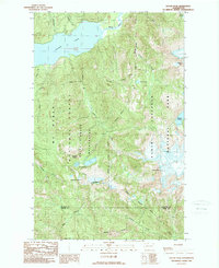
 1989 Grandy Lake1989 Print · USGSThe Skagit River valley in the late eighties shows a landscape defined by riverside settlements and mountain lakes. Researchers can trace the development of Concrete and Birdsview, locate the old Cem, or explore the environs of Lake Tyee.
 - 1989 Map of Marblemount
 1989 Marblemount1989 Print · USGSMarblemount and the Skagit valley are captured here in the late eighties as the region balanced conservation and mountain access. Genealogists and researchers can trace local landmarks like Corkindale, the Gaging Station, and the convergence of the Skagit River and Cascade River.
 - 1989 Map of Mount Triumph
 1989 Mount Triumph1989 Print · USGSThe North Cascades in the late eighties show the intersection of industrial utility and wilderness preservation. You can trace the Skagit River through Newhalem and find high-country landmarks like Thornton Lakes and Mount Triumph.
 - 1989 Map of Damnation Peak
 1989 Damnation Peak1989 Print · USGSHigh in the North Cascades during the late eighties, this provisional survey captures a remote wilderness at the boundary of Whatcom and Skagit counties. Backcountry researchers can trace the alpine drainages of Blum Lakes and summits like Mt Despair or Oakes Peak.
 - 1989 Map of Bacon Peak
 1989 Bacon Peak1989 Print · USGSThe northern reaches of the Cascades are captured in the late 1980s, documenting the meeting of Whatcom and Skagit counties. Trace the remote drainages of Noisy Creek and Diobsud Creek or locate alpine landmarks like Watson Lakes and Bacon Peak.2 unique versions available
 - 1989 Map of Twin Sisters Mtn.
 1989 Twin Sisters Mtn.1989 Print · USGSThe high Cascades of Whatcom and Skagit counties are documented here during the late eighties, showing a landscape shaped by glacial water and alpine peaks. Researchers can trace the Bell Pass Trail and locate remote landmarks like George Peterson Butte or Lake Wiseman.2 unique versions available
 - 1989 Map of Big Devil Peak
 1989 Big Devil Peak1989 Print · USGSSkagit County’s high wilderness areas are captured in the late 1980s at the meeting point of several major federal land preserves. Researchers can trace the drainage of the Skagit River and locate isolated landmarks like Monogram Lake and Lookout Mountain.
 - 1989 Map of Welker Peak
 1989 Welker Peak1989 Print · USGSThe North Cascades in the late 1980s are defined here by the waters of Baker Lake and the hydroelectric engineering of the Upper Baker Dam. Researchers can trace forest management sites like Koma Kulshan Guard Sta and several industrial Quarries.
 - 1989 Map of Baker Pass
 1989 Baker Pass1989 Print · USGSThe high alpine country of the North Cascades is documented here in the late eighties, just years after the wilderness area was formally established. Researchers can trace the path of the Railroad Grade, locate the Lookout Tower on Park Butte, and map the shifting margins of Squak Glacier.2 unique versions available
 - 1989 Map of Day Lake
 1989 Day Lake1989 Print · USGSSkagit County's timber-rich highlands were deeply mapped in the late eighties, documenting the drainages within the Mt Baker National Forest. Researchers can trace old forest access routes and waterways like Day Lake, Coal Mountain, and Iron Mtn.
 - 1989 Map of Oso
 1989 Oso1989 Print · USGSThe Stillaguamish valley and its surrounding peaks are captured here in the late eighties, showing the rural landscape of Snohomish County. Researchers can trace the riverfront settlements of Oso and Halterman or locate landmarks like the Fish Hatchery and the public Boat Ramp at Lake Cavanaugh.
 - 1989 Map of Mt Higgins
 1989 Mt Higgins1989 Print · USGSThe North Fork Stillaguamish River valley in the late 1980s shows a landscape defined by timber, small settlements, and high-altitude wilderness. Trace the river road through Hazel and Rowan or explore the high peaks of Mt Higgins and Skadulgwas Peak.
End of results
Showing maps 1-24 of 24
Top cities of Skagit County
- Mount Vernon historical maps
- Anacortes historical maps
- Sedro-Woolley historical maps
- Burlington historical maps
- La Conner historical maps
Frequently asked questions
- What are the different types of historical maps available for Skagit County?
- What is the oldest map of Skagit County?
- Where can I purchase historical maps of Skagit County for my home or office?
- Where can I download high-res historical maps of Skagit County?
- Are there historical topographic maps available for Skagit County?
- Is there historical aerial imagery available for Skagit County?
- Where are historical maps of Skagit County sourced from?