1950s Maps of Skamania County, Washington
Explore 21 historic maps of Skamania County from the 1950s. These maps offer a rare glimpse into what life looked like during the 1950s — showing old roads, neighborhoods, homes, and landmarks that have changed or disappeared over time.
Whether you're researching your family's past, planning a metal detecting trip, or studying how Skamania County's landscape evolved across the 1950s, these high-resolution maps are a powerful tool for exploring the history of this region.
- Focus on a specific era: All maps on this page are from the 1950s, giving you a focused view of this time period.
- See what’s changed: Compare century-old streets, trails, and buildings to today's modern landscape using overlays and satellite layers.
- Research with precision: Use these maps for genealogy, historical research, land use analysis, or educational projects.
- View, download, or print: Maps are fully viewable online in high resolution, and can be downloaded or printed for your own records.
Start exploring Skamania County's history through authentic maps from the 1950s. This is your window into the past.
Skamania County, WA maps
(21)- 1950 Map of Vancouver
 1950 Vancouver1950 Print · USGSCoastal Oregon and the lower Columbia River valley are captured in detail just after the war. Researchers can trace historic rail routes like the Southern Pacific or locate early settlements such as Vernonia, Gaston, and the Grand Ronde Indian Reservation.
 - 1950 Map of Vancouver, 1951 Print
 1950 Vancouver1951 Print · USGSThe Pacific Northwest urban corridor meets the rugged coast in the years following the war, showing the expansion of Portland and Vancouver. Genealogists and historians can trace the reach of the Southern Pacific RR and locate coastal communities like Tillamook, Seaside, and Tolovana Park.
 - 1950 Map of Yakima, 1951 Print
 1950 Yakima1951 Print · USGSThe Yakima Valley and the towering Cascades meet in this mid-century survey of South Central Washington. Genealogists and local historians can trace the irrigation-era growth of Yakima, the historic Fort Simcoe outpost, and the White Swan Mission on the Yakima Indian Reservation.
 - 1953 Map of Hoquiam
 1953 Hoquiam1953 Print · USGSSouthwest Washington in the early fifties shows a landscape shaped by timber, rail, and river commerce from the coast to the Cascades. Genealogists and historians can trace the development of timber towns like Ryderwood and the industrial hubs of Hoquiam and Kelso.2 unique versions available
 - 1953 Map of Lookout Mtn, 1956 Print
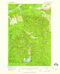
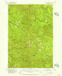 1953 Lookout Mtn1956 Print · USGSThe deep forests of Skamania County come into focus during the early fifties, showing a landscape of lookouts and timber management. Genealogists and historians can trace the locations of the Mineral Springs Guard Station, early sites like Spring Camp, and the winding East Fork Lewis River.3 unique versions available
 - 1953 Map of The Dalles, 1965 Print
 1953 The Dalles1965 Print · USGSThe Columbia River Gorge at mid-century shows a region being transformed by massive hydroelectric dams and a growing highway network. Researchers can trace the development of The Dalles Dam, locate the Maryhill Museum, and find old rail stops in Rufus, Wishram, and Arlington.3 unique versions available
 - 1954 Map of Bridal Veil, 1958 Print
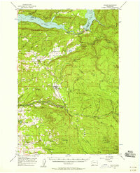
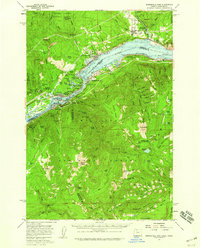
 1954 Bridal Veil1958 Print · USGSThe Columbia River Gorge in the mid-1950s was a bustling corridor of rail lines and early highways. Genealogists and historians can trace the foundations of riverside communities like Bridal Veil and Dodson or locate industrial sites like the Skamania Mine.4 unique versions available
 - 1954 Map of Camas, 1958 Print
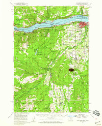
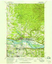 1954 Camas1958 Print · USGSThe Columbia River corridor in the mid-fifties shows the industrial growth of Camas and Washougal alongside the evolving suburbs of Gresham and Troutdale. Researchers can trace old school districts like Norway Sch and follow the S P & S RY through the river valley.3 unique versions available
 - 1956 Map of The Dalles
 1956 The Dalles1956 Print · USGSThe Columbia River Gorge and the high Cascades are captured in the mid-1950s, showing a vital corridor of rail and road. Researchers can trace the original path of The Old Oregon Trail or locate historical landmarks like the Maryhill Museum and Mount Hood.
 - 1956 Map of Yacolt, 1958 Print
 1956 Yacolt1958 Print · USGSIn the mid-1950s, the Clark County foothills were a landscape of logging camps and river power before the height of modernization. Researchers can trace the Northern Pacific Railroad route or locate family sites at Gravel Point Cem and the settlement of Venersborg.2 unique versions available
 - 1957 Map of Hoquiam
 1957 Hoquiam1957 Print · USGSCoastal timber ports and inland rail hubs define Southwest Washington during the late fifties. Genealogists can trace early twentieth-century settlements like Bordeaux, Tono, and Cosmopolis alongside the expanding tracks of the Northern Pacific.
 - 1957 Map of The Dalles
 1957 The Dalles1957 Print · USGSThe Columbia River Gorge and the high plateaus of the mid-1950s come alive on this detailed survey of northern Oregon and southern Washington. Researchers can trace the path of the Oregon Trail and The Old Barlow Road alongside river towns like The Dalles and Wishram.
 - 1957 Map of Bonneville Dam, 1959 Print
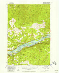
 1957 Bonneville Dam1959 Print · USGSThe Columbia River Gorge in the late fifties was a landscape of industrial power and remote forest trails. Map collectors can trace the mid-century footprints of Stevenson and Cascade Locks or locate landmarks like St Martins Hot Springs and the Bridge of the Gods.2 unique versions available
 - 1957 Map of Wind River, 1959 Print
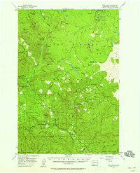 1957 Wind River1959 Print · USGSSkamania County's deep forest interior is captured here in the late fifties, showcasing a landscape of forestry research and mountain camps. Genealogists and historians can trace the development of Stabler and remote outposts like Government Mineral Springs and the Hemlock Ranger Sta.3 unique versions available
 - 1957 Map of Willard, 1959 Print
 1957 Willard1959 Print · USGSSkamania and Klickitat Counties are shown here during the late 1950s, highlighting the active timber and forest management culture of the Gifford Pinchot National Forest. Researchers can trace historic industrial sites like Mill A and Mill B or locate remote landmarks such as the Peterson Guard Sta and Ice Caves.3 unique versions available
 - 1957 Map of Hood River, 1959 Print
 1957 Hood River1959 Print · USGSThe Columbia River Gorge in the late fifties is captured here as a thriving corridor of rail, timber, and orchard life. Genealogists and historians can trace local landmarks like Pine Grove Cem, the community at Odell, and early forest service sites such as Kingsley Guard Sta.3 unique versions available
 - 1957 Map of Spirit Lake, 1959 Print
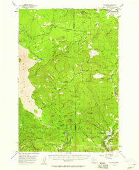
 1957 Spirit Lake1959 Print · USGSThe Gifford Pinchot National Forest in the late fifties is captured here as a thriving hub of recreation and mining before the 1980 eruption altered the landscape. Researchers can trace historic lakeside developments like Harmony Falls Lodge or locate early industrial sites such as the Polar Star Mine and the Cowlitz Chehalis & Cascade Railroad.3 unique versions available
 - 1958 Map of Mt St. Helens, 1959 Print
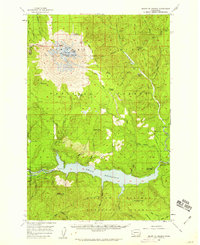 1958 Mt St. Helens1959 Print · USGSThe peaks and forests of Skamania County appear here in the late fifties, just as the Lewis River was being transformed by hydroelectric development. Hikers and historians can trace old routes like St Helens Way and locate early camps including Butte Camp and Jackpine Shelter.3 unique versions available
 - 1958 Map of Yakima, 1964 Print
 1958 Yakima1964 Print · USGSThe Yakima Valley in the late fifties shows a landscape of mountain peaks and irrigated plains at the height of its rail-era development. Researchers can trace the lineage of early settlements through sites like Fort Simcoe, the Wenas Cemetery, and the Yakima Indian Agency School.3 unique versions available
 - 1958 Map of Vancouver, 1968 Print
 1958 Vancouver1968 Print · USGSThe Lower Columbia and Willamette valleys thrive in the late sixties as major rail and river hubs. Genealogists and historians can trace the development of Portland, identify the grounds of Camp Withycombe, and locate coastal landmarks from Tillamook Head to Garibaldi.3 unique versions available
 - 1958 Map of Hoquiam, 1969 Print
 1958 Hoquiam1969 Print · USGSSouthwest Washington and the Columbia River estuary appear here in the mid-century, before major landscape shifts. Researchers can trace the rail lines of the Northern Pacific, locate the Fort Henness Site, or explore the Naselle Air Force Station.2 unique versions available
End of results
Showing maps 1-21 of 21
Top cities of Skamania County
Frequently asked questions
- What are the different types of historical maps available for Skamania County?
- What is the oldest map of Skamania County?
- Where can I purchase historical maps of Skamania County for my home or office?
- Where can I download high-res historical maps of Skamania County?
- Are there historical topographic maps available for Skamania County?
- Is there historical aerial imagery available for Skamania County?
- Where are historical maps of Skamania County sourced from?