1990s Maps of Skamania County, Washington
Explore 44 historic maps of Skamania County from the 1990s. These maps offer a rare glimpse into what life looked like during the 1990s — showing old roads, neighborhoods, homes, and landmarks that have changed or disappeared over time.
Whether you're researching your family's past, planning a metal detecting trip, or studying how Skamania County's landscape evolved across the 1990s, these high-resolution maps are a powerful tool for exploring the history of this region.
- Focus on a specific era: All maps on this page are from the 1990s, giving you a focused view of this time period.
- See what’s changed: Compare century-old streets, trails, and buildings to today's modern landscape using overlays and satellite layers.
- Research with precision: Use these maps for genealogy, historical research, land use analysis, or educational projects.
- View, download, or print: Maps are fully viewable online in high resolution, and can be downloaded or printed for your own records.
Start exploring Skamania County's history through authentic maps from the 1990s. This is your window into the past.
Skamania County, WA maps
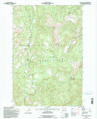
(44)- 1994 Map of Hood River, 1996 Print
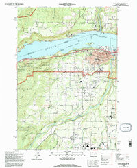 1994 Hood River1996 Print · USGSThe Columbia River Gorge area in the mid-1990s reflects a landscape shaped by orchards, timber, and the river economy. Genealogists and historians can trace family locations through Idelwild Cem, Frankton Sch, and the settlements of Underwood and Rockford.
 - 1994 Map of Mc Coy Peak, 1996 Print
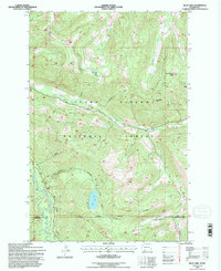
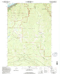
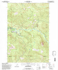
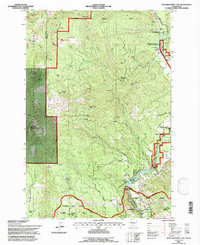
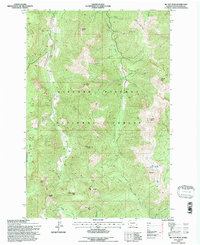 1994 Mc Coy Peak1996 Print · USGSSkamania County's high Cascades are shown here in the mid-1990s as a wilderness of sharp peaks and timbered ridges. Hikers and researchers can trace backcountry routes like the French Creek Trail or locate remote landmarks including Yellow Jacket Pass and McCoy Peak.
 - 1994 Map of Mt. Defiance, 1996 Print
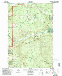
 1994 Mt. Defiance1996 Print · USGSThe Columbia River Gorge in the mid-nineties shows a landscape defined by federal forests and riverfront industry. Researchers can trace the path of the Old Wagon Road and locate the historic timber operations at Mill A and the Little White Salmon Nat Fish Hatchery.
 - 1994 Map of East Canyon Ridge, 1996 Print
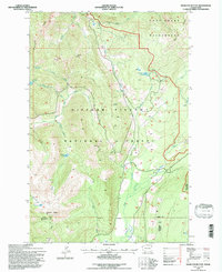
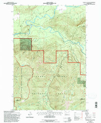
 1994 East Canyon Ridge1996 Print · USGSSkamania County's high ridges and river valleys are captured here in the mid-1990s as the timber and recreation economy shaped the land. Researchers can locate remote sites like the Mine near Buck Creek or trace high-country landmarks including Summit Prairie and Council Lake.
 - 1994 Map of Blue Lake, 1996 Print
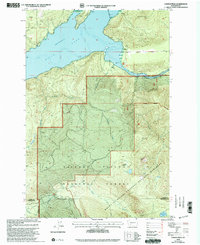
 1994 Blue Lake1996 Print · USGSThe southern Washington Cascades are mapped here in the mid-nineties, showing the intersection of Lewis and Skamania counties within the Gifford Pinchot National Forest. Researchers can trace remote water features like Blue Lake and Jackpot Lake or locate high-country landmarks such as Castle Butte and the Twin Sisters.
 - 1994 Map of Hamilton Buttes, 1996 Print
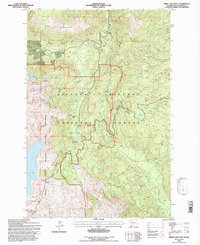
 1994 Hamilton Buttes1996 Print · USGSThe Cascades high country of Lewis County comes to life in the mid-nineties, showing a landscape defined by protected wilderness and timber management. Hikers and researchers can locate landmarks like Sanctuary Arch and St Michael Lake, or trace the rugged Goat Ridge.
 - 1994 Map of Bridal Veil, 1996 Print
 1994 Bridal Veil1996 Print · USGSThe Columbia River Gorge in the mid-nineties shows a landscape defined by dramatic cliffs and the legacy of early highway engineering. Researchers can trace the paths to iconic sites like Vista House, Rooster Rock, and the historic settlement of Bridal Veil.
 - 1994 Map of Carson, 1996 Print
 1994 Carson1996 Print · USGSThe Columbia River Gorge in the mid-nineties shows the vital intersection of Pacific Northwest timber lands and major transport corridors. Trace the paths of the Union Pacific Railroad and Pacific Crest National Scenic Trail past Carson and Wyeth.
 - 1994 Map of French Butte, 1996 Print
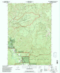
 1994 French Butte1996 Print · USGSThe high backcountry of Skamania County is documented here in the mid-1990s as it transitioned under modern forest management. Researchers can trace the network of old forest roads connecting landmarks like Elk Pass, Snyder Pasture, and the overlook at French Butte.
 - 1994 Map of Tanner Butte, 1996 Print
 1994 Tanner Butte1996 Print · USGSThe Columbia River Gorge in the mid-1990s reveals a landscape of protected wilderness and dramatic waterfalls along the Washington border. Outdoor researchers and hikers can trace the paths to Elowah Falls, Tanner Butte, and the remote Dublin Lake.
 - 1994 Map of Bonneville Dam, 1996 Print
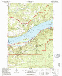
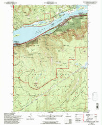
 1994 Bonneville Dam1996 Print · USGSThe Columbia River Gorge in the mid-nineties shows a landscape defined by massive hydropower and river traffic. Researchers can trace the engineering footprint of Bonneville Dam, find the Iman Cem, and follow the Bridge of the Gods into Cascade Locks.
 - 1994 Map of Greenhorn Buttes, 1996 Print
 1994 Greenhorn Buttes1996 Print · USGSThe northern Cascades transition from river valleys to high timbered ridges during the mid-1990s. Researchers can trace the varied terrain from the banks of the Cispus River up to the summits of Iron Creek Butte and Huffaker Mtn.
 - 1994 Map of Green Mountain, 1996 Print
 1994 Green Mountain1996 Print · USGSThe High Cascades in the mid-nineties come into focus here, showing the intersection of forest service lands and tribal boundaries. Trace the high-altitude Pacific Crest National Scenic Trail past Takhlakh Lake and the LAVA fields.
 - 1994 Map of Beacon Rock, 1996 Print
 1994 Beacon Rock1996 Print · USGSThe northern banks of the Columbia River Gorge appear in great detail during the mid-nineties, showing a landscape dedicated to conservation and hiking. Hikers and historians can trace the Pacific Crest National Scenic Trail as it passes Three Corner Rock and Hardy Falls.
 - 1994 Map of Cowlitz Falls, 1996 Print
 1994 Cowlitz Falls1996 Print · USGSThe Lewis and Skamania county line runs through this mid-nineties survey of the Cowlitz River basin. Researchers can trace the timber and water landscape from the Gaging Station and Landing Strip to landmarks like Quartz Creek Big Trees.
 - 1994 Map of Tower Rock, 1996 Print
 1994 Tower Rock1996 Print · USGSThe southern Washington Cascades appear in detail during the mid-1990s as the Cispus River basin is managed for education and recreation. Researchers can locate specific sites like the Cispus Environmental Learning Center, Tower Rock, and the North Fork Group Campground.
 - 1994 Map of Spirit Lake East, 1996 Print
 1994 Spirit Lake East1996 Print · USGSThe slopes east of Mount St. Helens in the mid-1990s show a landscape shaped by volcanic force and gradual rebirth. Traces of the past remain at the Miners Car Interpretive Site, while hikers can follow the Norway Pass Trailhead toward Spirit Lake.
 - 1994 Map of Multnomah Falls, 1997 Print
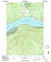
 1994 Multnomah Falls1997 Print · USGSThe Columbia River Gorge in the 1990s shows a landscape of protected wilderness and iconic waterfalls. Researchers can trace the riverfront settlements of Warrendale and Dodson or locate landmarks like Larch Mtn and Saint Peters Dome.
 - 1994 Map of Willard, 1997 Print
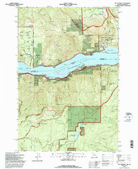
 1994 Willard1997 Print · USGSSkamania County's timber and river heritage is captured in the mid-1990s, where national forest lands meet the Columbia River Gorge. Genealogists and hikers can locate the Cem near Mill A Flat or trace the volcanic reach of the Big Lava Bed.
 - 1994 Map of Big Huckleberry Mtn, 1997 Print
 1994 Big Huckleberry Mtn1997 Print · USGSThe Gifford Pinchot National Forest in the 1990s offers a look at forest research and high-country trails. Trace the Pacific Crest National Scenic Trail past Big Huckleberry Mtn and find the Suspension Bridge over the Wind River.
 - 1994 Map of Northwestern Lake, 1997 Print
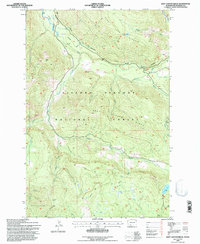
 1994 Northwestern Lake1997 Print · USGSKlickitat County was a landscape of forest lookouts and river canyons in the mid-nineties. You can trace early timber and utility infrastructure at BZ Corner, Nestor Peak Lookout, and the Concrete Dam along Wilson Creek.
 - 1998 Map of Vanson Peak, 2003 Print
 1998 Vanson Peak2003 Print · USGSThe Lewis and Cowlitz county borders intersect here during the late 1990s, where protected volcanic monuments meet national forest lands. Researchers can trace the high-elevation terrain around Vanson Peak, Vanson Lake, and the shorelines of Riffe Lake.
 - 1998 Map of Cedar Flats, 2003 Print
 1998 Cedar Flats2003 Print · USGSSkamania County's timberlands and waterways are captured here in the late nineties, documenting the area surrounding the Swift Reservoir. Historians and hikers can trace the Cedar Flats Nature Trail or locate the settlement at Northwoods and the Eagle Cliffs.
 - 1998 Map of Lookout Mountain, 2003 Print
 1998 Lookout Mountain2003 Print · USGSSkamania County's forested uplands are captured here in the late nineties, showcasing a rugged volcanic landscape shaped by the West Crater lava flows. Hikers and historians can trace the Pacific Crest National Scenic Trail as it winds past Mowich Butte and the Mowich Campground.
 - 1998 Map of Steamboat Mountain, 2003 Print
 1998 Steamboat Mountain2003 Print · USGSThe Gifford Pinchot National Forest in the late nineties is documented here in high detail, showing the intersection of recreation and resource land. Trace the Pacific Crest National Scenic Trail past Steamboat Mtn and the Williams Mine.
Showing maps 1-25 of 44
Top cities of Skamania County
Frequently asked questions
- What are the different types of historical maps available for Skamania County?
- What is the oldest map of Skamania County?
- Where can I purchase historical maps of Skamania County for my home or office?
- Where can I download high-res historical maps of Skamania County?
- Are there historical topographic maps available for Skamania County?
- Is there historical aerial imagery available for Skamania County?
- Where are historical maps of Skamania County sourced from?