1980s Maps of Skamania County, Washington
Explore 27 historic maps of Skamania County from the 1980s. These maps offer a rare glimpse into what life looked like during the 1980s — showing old roads, neighborhoods, homes, and landmarks that have changed or disappeared over time.
Whether you're researching your family's past, planning a metal detecting trip, or studying how Skamania County's landscape evolved across the 1980s, these high-resolution maps are a powerful tool for exploring the history of this region.
- Focus on a specific era: All maps on this page are from the 1980s, giving you a focused view of this time period.
- See what’s changed: Compare century-old streets, trails, and buildings to today's modern landscape using overlays and satellite layers.
- Research with precision: Use these maps for genealogy, historical research, land use analysis, or educational projects.
- View, download, or print: Maps are fully viewable online in high resolution, and can be downloaded or printed for your own records.
Start exploring Skamania County's history through authentic maps from the 1980s. This is your window into the past.
Skamania County, WA maps
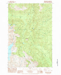
(27)- 1982 Map of Hood River, 1983 Print
 1982 Hood River1983 Print · USGSThe Columbia River Gorge in the early eighties shows a landscape shaped by massive hydroelectric projects and deep-rooted timber communities. Researchers can trace the rail-and-river network through Cascade Locks and The Dalles Dam, or explore the terrain of Gifford Pinchot National Forest.
 - 1983 Map of Big Huckleberry Mtn
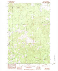
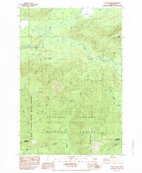
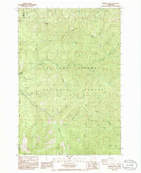
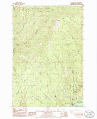
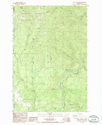
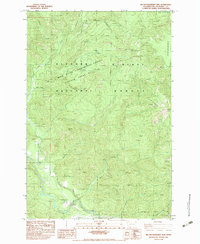 1983 Big Huckleberry Mtn1983 Print · USGSSkamania County was a landscape of scientific forestry and mountain terrain in the early 1980s. Trace the reach of the Wind River Experimental Forest Division and locate landmarks like the Suspension Bridge and Big Huckleberry Mtn.
 - 1983 Map of Little Huckleberry Mtn
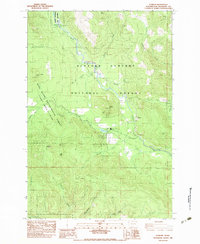
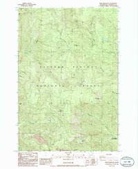
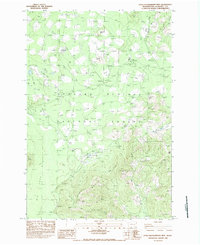 1983 Little Huckleberry Mtn1983 Print · USGSSkamania County’s mountain interior is captured here in the early eighties, showcasing a landscape of volcanic fields and timberlands. Researchers can trace the geological features of the Lava Bed and Ice Caves or locate Peterson Prairie Campground.
 - 1983 Map of Termination Point
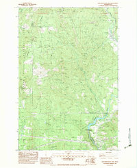
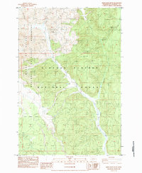
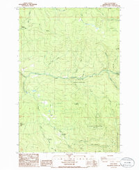
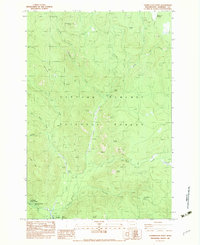 1983 Termination Point1983 Print · USGSDeep in the mountain forests of Skamania County in the early eighties, this area shows a landscape defined by resource management and natural springs. Map collectors can trace the Wind River Mine, Government Mineral Springs, and the Carson National Fish Hatchery.
 - 1983 Map of Gifford Peak
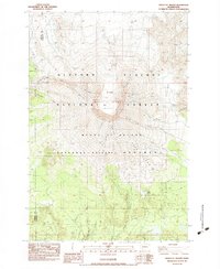
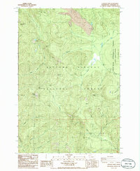
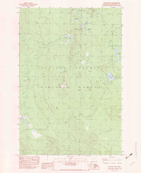 1983 Gifford Peak1983 Print · USGSSkamania County's high-country wilderness is captured here in the early eighties, centered on the volcanic terrain of the Indian Heaven region. Hikers and historians can trace old trails and landmarks like the Indian Race Track, Goose Lake, and several Lava Caves.2 unique versions available
 - 1983 Map of Willard
 1983 Willard1983 Print · USGSSkamania County's forested interior is captured here in the early 1980s as a landscape of active timber work and fish conservation. Researchers can trace the layout of Willard, locate the Willard National Fish Hatchery, and identify old sites like Mill A.
 - 1983 Map of Guler Mtn
 1983 Guler Mtn1983 Print · USGSKlickitat County as it appeared in the early 1980s reveals a landscape of volcanic caves and early timber sites. You can trace the locations of the Gablehouse Mill (Site) or explore the unique geology of Cheese Cave and the Lava Bridge.
 - 1983 Map of Stabler
 1983 Stabler1983 Print · USGSSkamania County's timber and conservation heritage is on full display in this early 1980s look at the Wind River valley. Researchers and genealogists can trace the footprint of the Wind River Ranger Station, the historic Stabler settlement, and the Wind River Arboretum.
 - 1983 Map of Northwestern Lake
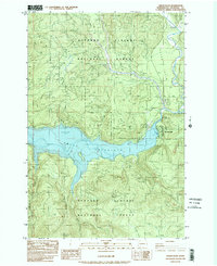
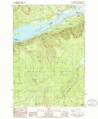
 1983 Northwestern Lake1983 Print · USGSThe White Salmon River canyon in the early eighties serves as a rugged backdrop for timber and utility infrastructure. Genealogists and hikers can locate the B Z Corner settlement, the Nestor Peak Look Out House, and the historic Lumber Flume.
 - 1983 Map of Mount St. Helens, 1984 Print
 1983 Mount St. Helens1984 Print · USGSSkamania County's transformed landscape is documented here in the early 1980s, shortly after the volcanic eruption changed the face of the Cascades. Geologists and local historians can trace the new morphology of the 1980 Crater and The Breach alongside surviving features like the Lava Caves and June Lake.3 unique versions available
 - 1983 Map of Cowlitz Falls, 1984 Print
 1983 Cowlitz Falls1984 Print · USGSThe Gifford Pinchot National Forest meets the Mount St. Helens National Volcanic Monument in the early eighties. Researchers can trace remote mountain access via Pack Trail and 4WD routes to sites like Kelly Ranch, Deep Lake, and Cowlitz Falls.2 unique versions available
 - 1983 Map of Smith Creek Butte, 1984 Print
 1983 Smith Creek Butte1984 Print · USGSThe Gifford Pinchot National Forest is shown here just years after the 1980 eruption, recording the blast's path across the landscape. Trace the Eruption Impact Line and find landmarks like Ape Canyon, Paradise Falls, and the Jackpine Shelter.
 - 1983 Map of Cedar Flats, 1984 Print
 1983 Cedar Flats1984 Print · USGSThe Gifford Pinchot National Forest is shown here in the early 1980s following the Mount St. Helens eruption. Trace the developing recreation and utility sites around Swift Reservoir, including Northwoods and Swift Forest Campground.2 unique versions available
 - 1984 Map of Spirit Lake West
 1984 Spirit Lake West1984 Print · USGSSkamania County and the surrounding peaks appear here in the early 1980s, documenting a landscape reshaped by volcanic activity. Researchers can trace the Pre-Eruption Channel and locate Spirit Lake and Coldwater Lake.2 unique versions available
 - 1984 Map of Mt Mitchell
 1984 Mt Mitchell1984 Print · USGSThe Cascades of Skamania County appear in the mid-eighties as a landscape of hydroelectric power and volcanic geology. You can trace the Lewis River industrial sites like the Log Sorting Yard or explore geologic landmarks including Ape Cave and Mount Mitchell.
 - 1984 Map of Vanson Peak
 1984 Vanson Peak1984 Print · USGSThe high Cascades of Lewis and Skamania counties are captured here in the early 1980s, shortly after the Mount St. Helens eruption. Trace the rugged terrain from Vanson Peak down to the Cowlitz River and the inundated shores of Riffe Lake.
 - 1984 Map of Spirit Lake East
 1984 Spirit Lake East1984 Print · USGSSkamania County in the mid-1980s reveals a landscape still reeling from volcanic eruption. Researchers can trace the massive areas of blowdown timber near Spirit Lake and locate high-country landmarks like Norway Pass, Harmony Falls, and Goat Mountain.
 - 1986 Map of Gumboot Mtn
 1986 Gumboot Mtn1986 Print · USGSSkamania and Clark Counties are shown in the mid-1980s as a landscape of timber and mountain peaks within the Gifford Pinchot National Forest. Researchers can locate old mining sites like Miners Mines and topographic landmarks including Saturday Rock and Silver Star Mountain.2 unique versions available
 - 1986 Map of Multnomah Falls
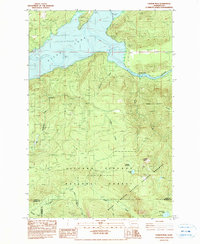
 1986 Multnomah Falls1986 Print · USGSThe Columbia River Gorge in the mid-eighties shows a landscape of dramatic cataracts and vital transit routes. Trace the historic paths between Skamania Landing and Warrendale, or locate landmarks like Multnomah Falls and the towering Saint Peters Dome.2 unique versions available
 - 1986 Map of Siouxon Peak
 1986 Siouxon Peak1986 Print · USGSThe southern Washington Cascades appear in the mid-1980s as a managed landscape of timber and trails. Collectors can trace the remote Hickmans Cabin, industrial sites like the Quarry, and the high ridges of Siouxon Peak and Calamity Pk.2 unique versions available
 - 1986 Map of Beacon Rock
 1986 Beacon Rock1986 Print · USGSSkamania County's Columbia River Gorge appears here in the mid-eighties as a hub of recreation and utility. You can trace the Pacific Crest National Scenic Trail past Hardy Falls and locate old landmarks like Hamilton Mtn and the Three Corner Rock Trailhead.2 unique versions available
 - 1986 Map of Bare Mountain
 1986 Bare Mountain1986 Print · USGSSkamania County's high forest country is captured in the mid-1980s, showcasing a landscape of fire lookouts and spring-fed watersheds. Researchers can locate the Government Mineral Springs, trace the path of Trapper Creek, and find the remote Soda Peaks Lake.2 unique versions available
 - 1986 Map of Dole
 1986 Dole1986 Print · USGSThe East Fork Lewis River basin in the mid-eighties shows a landscape transition from timber production to state and national park management. Genealogists and outdoor historians can locate the Dole settlement or trace landmarks like Horseshoe Falls and Yacolt Reservoir.2 unique versions available
 - 1986 Map of Lookout Mtn
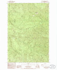
 1986 Lookout Mtn1986 Print · USGSSkamania County's timber and research lands are captured here in the mid-1980s, centered on the Gifford Pinchot National Forest. Researchers and hikers can trace old forest access points and landmarks like Fourth of July Camp, West Crater, and the Wind River Experimental Forest.2 unique versions available
 - 1986 Map of Bobs Mountain
 1986 Bobs Mountain1986 Print · USGSSkamania County's forested ridges and river valleys are captured here in the mid-1980s during a period of active timber and land management. Researchers can locate remote industrial sites like the Skamania Mine and Last Chance Mine or archaeological landmarks like the Silver Star Indian Pits.2 unique versions available
Showing maps 1-25 of 27
Top cities of Skamania County
Frequently asked questions
- What are the different types of historical maps available for Skamania County?
- What is the oldest map of Skamania County?
- Where can I purchase historical maps of Skamania County for my home or office?
- Where can I download high-res historical maps of Skamania County?
- Are there historical topographic maps available for Skamania County?
- Is there historical aerial imagery available for Skamania County?
- Where are historical maps of Skamania County sourced from?