1960s Maps of Skamania County, Washington
Explore 11 historic maps of Skamania County from the 1960s. These maps offer a rare glimpse into what life looked like during the 1960s — showing old roads, neighborhoods, homes, and landmarks that have changed or disappeared over time.
Whether you're researching your family's past, planning a metal detecting trip, or studying how Skamania County's landscape evolved across the 1960s, these high-resolution maps are a powerful tool for exploring the history of this region.
- Focus on a specific era: All maps on this page are from the 1960s, giving you a focused view of this time period.
- See what’s changed: Compare century-old streets, trails, and buildings to today's modern landscape using overlays and satellite layers.
- Research with precision: Use these maps for genealogy, historical research, land use analysis, or educational projects.
- View, download, or print: Maps are fully viewable online in high resolution, and can be downloaded or printed for your own records.
Start exploring Skamania County's history through authentic maps from the 1960s. This is your window into the past.
Skamania County, WA maps
(11)- 1961 Map of Yakima
 1961 Yakima1961 Print · USGSCentral Washington thrived in the mid-century as an agricultural powerhouse defined by the Yakima River. Trace local roots through Medicine Valley School, Fort Simcoe, and the rail lines of the Northern Pacific RR.
 - 1962 Map of Hoquiam
 1962 Hoquiam1962 Print · USGSSouthwest Washington in the late fifties is defined by the bustling timber ports of Hoquiam and the rail-linked commerce of the interior valleys. Genealogists and historians can trace the early footprints of settlements like Raymond and Pe Ell, or locate family sites at Grand Mound Cem and Odd Fellows Cem.
 - 1964 Map of Vancouver
 1964 Vancouver1964 Print · USGSThe Pacific Northwest interior and coast are shown here in the 1960s, from the Portland metropolitan hub to the rugged Pacific shoreline. Researchers can trace the legacy of the Grand Ronde Indian Reservation, the early layout of McMinnville, and the maritime approaches near Tillamook Head.
 - 1965 Map of Burnt Peak, 1966 Print
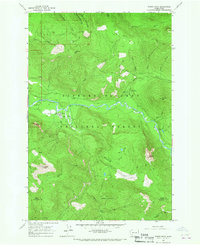
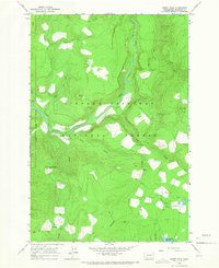 1965 Burnt Peak1966 Print · USGSSkamania County's high country is captured in the mid-sixties, showing a landscape defined by forestry and remote lookouts. You can trace early forest access routes like the Pack Trail and locate recreation sites such as Curly Creek Campground or the Burnt Peak Lookout 4106.
 - 1965 Map of Lone Butte, 1967 Print
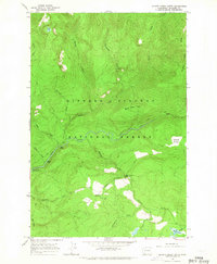
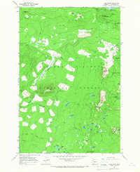 1965 Lone Butte1967 Print · USGSSkamania County's high volcanic plateaus and alpine lakes are captured here in the mid-1960s. Outdoor historians and researchers can trace the original Cascade Crest Trail past seasonal outposts like Mosquito Lake Station and Tillicum Campground.2 unique versions available
 - 1965 Map of Greenhorn Buttes, 1967 Print
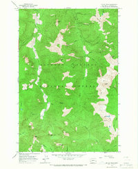
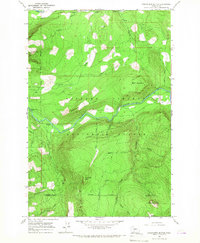 1965 Greenhorn Buttes1967 Print · USGSThe Lewis and Skamania county line crosses this forested landscape during the mid-sixties, an era of active forest management and mountain recreation. Researchers can trace the winding Cispus River and find landmarks like Huffaker Bridge, Iron Creek Campground, and the high peaks of Greenhorn Buttes.
 - 1965 Map of Spencer Butte, 1967 Print
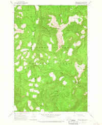
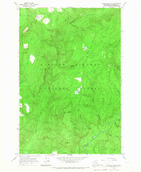 1965 Spencer Butte1967 Print · USGSSkamania County's wilderness is shown in the mid-sixties, dominated by the peaks and drainages within the Gifford Pinchot National Forest. Follow the Pack Trail network to find remote landmarks like Spencer Butte, Lower Falls on the Lewis River, and Spencer Meadow.
 - 1965 Map of Tower Rock, 1967 Print
 1965 Tower Rock1967 Print · USGSThe Cispus River valley in the mid-sixties served as a hub for conservation efforts and forest management within the Gifford Pinchot National Forest. Trace the layout of the Cispus Job Corps Conservation Center and find historic fire lookouts on Burley Mtn.2 unique versions available
 - 1965 Map of Quartz Creek Butte, 1967 Print
 1965 Quartz Creek Butte1967 Print · USGSSkamania County's wilderness is captured in the mid-1960s, showing a landscape defined by the Lewis River and steep timberlands. Researchers can trace early recreational footprints at the Lewis River Campground and follow the rugged Pack Trail past Little Niagara Falls.2 unique versions available
 - 1965 Map of Mc Coy Peak, 1967 Print
 1965 Mc Coy Peak1967 Print · USGSThe high backcountry of Skamania County is captured here in the mid-1960s, showing a landscape defined by ridgelines and forest trails. Researchers can trace historic access routes like the Bear Creek Pack Trail and locate isolated features like the Mine or Yellow Jacket Pass.2 unique versions available
 - 1965 Map of French Butte, 1967 Print
 1965 French Butte1967 Print · USGSSkamania County's high country is captured here in the mid-sixties, a period of active forest management and recreation. Trace the remote network of trails leading to the Iron Creek Guard Station, Pinto Rock, and the waters of Badger Lake.
End of results
Showing maps 1-11 of 11
Top cities of Skamania County
Frequently asked questions
- What are the different types of historical maps available for Skamania County?
- What is the oldest map of Skamania County?
- Where can I purchase historical maps of Skamania County for my home or office?
- Where can I download high-res historical maps of Skamania County?
- Are there historical topographic maps available for Skamania County?
- Is there historical aerial imagery available for Skamania County?
- Where are historical maps of Skamania County sourced from?