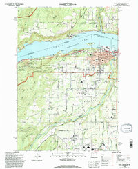
1994 Map of Hood River
USGS Topo · Published 1996About this map
The Columbia River serves as the focal point of this mid-1990s landscape, bridging the communities of Hood River and White Salmon across the state line. On the Oregon side, the settlement pattern reveals a transition from the urban core to the orchard-filled Hood River Valley, where small communities like Oak Grove and Odell are situated among a complex network of creeks such as Indian Creek and Lenz Creek. The industrial and agricultural backbone of the region is evident in the presence of the Powerdale Dam and the Mid Columbia Exper Sta, illustrating the long-standing reliance on the river and soil.
Find a feature on this map
83 named features on this map. Tap any name to fly to it.
Don’t see what you’re looking for? This feature index may not catch every label — zoom into the map to look around manually.
Map Details
Editions of this 1994 Hood River Map
This is the sole edition of this map. No revisions or reprints were ever made.
Other maps of this area

1926 · Hood River
USGS Topo · 1:125,000

1929 · Hood River
USGS Topo · 1:125,000

1934 · The Dalles
USGS Topo · 1:125,000

1953 · The Dalles
USGS Topo · 1:250,000

1956 · The Dalles
USGS Topo · 1:250,000

1957 · The Dalles
USGS Topo · 1:250,000

1957 · Willard
USGS Topo · 1:62,500

1957 · White Salmon
USGS Topo · 1:62,500

1957 · Husum
USGS Topo · 1:62,500

1957 · Hood River
USGS Topo · 1:62,500