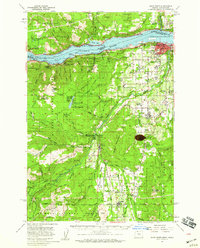
1957 Map of Hood River
USGS Topo · Published 1959About this map
The Columbia River serves as the central artery for this mid-century look at the Gorge, where the Union Pacific and Spokane Portland and Seattle railroads flank the water. To the south, the landscape is defined by the agricultural and timber rhythms of the Hood River valley, connecting settlements like Odell, Dee, and Parkdale. The presence of the OSC Ag Exp Sta and numerous schools like Central Vale Sch and Wy East High Sch highlights the area's development as a primary fruit-growing region. Higher elevations are dominated by the Mt Hood National Forest and Gifford Pinchot National Forest, with landmarks such as Mt Defiance and Bald Butte overlooking the river. Industrial sites like Mill A and Mill B near White Salmon indicate the ongoing importance of the timber trade during this era of post-war growth.
Find a feature on this map
87 named features on this map. Tap any name to fly to it.
Don’t see what you’re looking for? This feature index may not catch every label — zoom into the map to look around manually.
Map Details
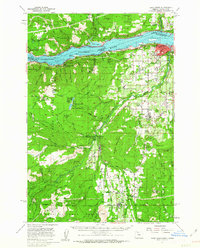
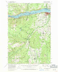
Editions of this 1957 Hood River Map
3 editions found
Other maps of this area

1924 · Mount Hood
USGS Topo · 1:125,000

1926 · Hood River
USGS Topo · 1:125,000

1927 · Mount Hood
USGS Topo · 1:125,000

1929 · Hood River
USGS Topo · 1:125,000

1930 · Dufur
USGS Topo · 1:125,000

1934 · Dufur
USGS Topo · 1:125,000

1934 · The Dalles
USGS Topo · 1:125,000

1953 · The Dalles
USGS Topo · 1:250,000

1956 · The Dalles
USGS Topo · 1:250,000

1957 · The Dalles
USGS Topo · 1:250,000