1960s Maps of Spokane, Washington
Explore 6 historic maps of Spokane from the 1960s. These maps offer a rare glimpse into what life looked like during the 1960s — showing old roads, neighborhoods, homes, and landmarks that have changed or disappeared over time.
Whether you're researching your family's past, planning a metal detecting trip, or studying how Spokane's landscape evolved across the 1960s, these high-resolution maps are a powerful tool for exploring the history of this region.
- Focus on a specific era: All maps on this page are from the 1960s, giving you a focused view of this time period.
- See what’s changed: Compare century-old streets, trails, and buildings to today's modern landscape using overlays and satellite layers.
- Research with precision: Use these maps for genealogy, historical research, land use analysis, or educational projects.
- View, download, or print: Maps are fully viewable online in high resolution, and can be downloaded or printed for your own records.
Start exploring Spokane's history through authentic maps from the 1960s. This is your window into the past.
Spokane, WA maps
(6)- 1963 Map of Four Lakes, 1964 Print
 1963 Four Lakes1964 Print · USGSSpokane County's aviation and rail infrastructure are on full display in the early 1960s, from the runways of Geiger Field to the surrounding hills. Genealogists and researchers can trace the settlement patterns at Four Lakes, Hayford, and old burial sites like Green Mound Cem.
 - 1963 Map of Spokane SW, 1964 Print
 1963 Spokane SW1964 Print · USGSThe southern fringes of Spokane and the rail-heavy valley at Marshall are captured here during the suburban expansion of the early sixties. Researchers can trace family history through local sites like Glenora Ch, Windsor Sch, and the Northwest Memorial Garden.
 - 1963 Map of Spokane SE, 1964 Print
 1963 Spokane SE1964 Print · USGSSpokane's southern outskirts and the Moran Prairie were characterized by broadcasting hubs and hilltop ranches in the 1960s. Genealogists can locate family landmarks like Moran Cem or the Morning Star Ranch while tracing the Old Railroad Grade.
 - 1963 Map of Airway Heights, 1964 Print
 1963 Airway Heights1964 Print · USGSWestern Spokane County's aviation and military landscape is captured here during the mid-sixties growth of the Inland Empire. Researchers can trace the development of Airway Heights and Fairchild Air Force Base alongside rural landmarks like Stevens Township Hall and Sunset Sch.
 - 1963 Map of Spokane NW, 1964 Print
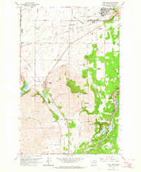
 1963 Spokane NW1964 Print · USGSSpokane emerges as a major Inland Empire rail and educational hub in the early sixties. Genealogists and researchers can trace the city's growth from Five Mile Prairie down to the historic Browne Addition, locating Fort Wright and dozens of neighborhood schools.
 - 1963 Map of Spokane NE, 1964 Print
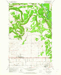
 1963 Spokane NE1964 Print · USGSSpokane in the early sixties was a bustling hub of rail transport and suburban growth along the river. Genealogists and local historians can trace the foundations of Millwood, the expansive Hutton Settlement, and the runways of Felts Field.
End of results
Showing maps 1-6 of 6
Top cities near Spokane
- Spokane Valley historical maps
- Cheney historical maps
- Airway Heights historical maps
- Colbert historical maps
- Fairwood historical maps
- Mead historical maps
See more
Top neighborhoods of Spokane
- Hillyard historical maps
- Balboa / South Indian Trail historical maps
- Shiloh Hills historical maps
- Lincoln Heights historical maps
- Nevada Heights historical maps
- Northwest historical maps
See more
Frequently asked questions
- What are the different types of historical maps available for Spokane?
- What is the oldest map of Spokane?
- Where can I purchase historical maps of Spokane for my home or office?
- Where can I download high-res historical maps of Spokane?
- Are there historical topographic maps available for Spokane?
- Is there historical aerial imagery available for Spokane?
- Where are historical maps of Spokane sourced from?