1970s Maps of Stevens County, Washington
Explore 9 historic maps of Stevens County from the 1970s. These maps offer a rare glimpse into what life looked like during the 1970s — showing old roads, neighborhoods, homes, and landmarks that have changed or disappeared over time.
Whether you're researching your family's past, planning a metal detecting trip, or studying how Stevens County's landscape evolved across the 1970s, these high-resolution maps are a powerful tool for exploring the history of this region.
- Focus on a specific era: All maps on this page are from the 1970s, giving you a focused view of this time period.
- See what’s changed: Compare century-old streets, trails, and buildings to today's modern landscape using overlays and satellite layers.
- Research with precision: Use these maps for genealogy, historical research, land use analysis, or educational projects.
- View, download, or print: Maps are fully viewable online in high resolution, and can be downloaded or printed for your own records.
Start exploring Stevens County's history through authentic maps from the 1970s. This is your window into the past.
Stevens County, WA maps
(9)- 1973 Map of Clayton, 1976 Print
 1973 Clayton1976 Print · USGSThe Stevens and Spokane county line in the early 1970s is a landscape of valley farms and timbered peaks. Genealogists and local historians can trace the rural layout of Williams Valley through family-named landmarks like Williams Valley Hillside Cem and the Burroughs Sch.
 - 1973 Map of Wellpinit, 1976 Print
 1973 Wellpinit1976 Print · USGSIn the early 1970s, the Spokane Indian Reservation landscape centered around the settlement of Wellpinit. Researchers can trace local lineage at the Chief Lot Cem and explore family-named landmarks like Joe Sherwood Road near Little Chamokane Falls.
 - 1973 Map of Long Lake, 1977 Print
 1973 Long Lake1977 Print · USGSThe Spokane River corridor in the early 1970s reveals a landscape shaped by hydroelectric power and rural industry at the meeting of three counties. Researchers can trace the shoreline of Long Lake and locate local landmarks such as Long Lake Dam, the settlement of Crescent, and Chamokane Falls.
 - 1973 Map of Four Mound Prairie, 1977 Print
 1973 Four Mound Prairie1977 Print · USGSThe Spokane River plateau in the early 1970s is shown here at the transition from farm country to the river's edge. Researchers can trace rural landmarks and family road names like Central Sch, Four Mound Fire Station, and Knight Lake.
 - 1973 Map of Nine Mile Falls, 1977 Print
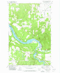 1973 Nine Mile Falls1977 Print · USGSThe Spokane River valley in the early 1970s serves as a crossroads of frontier history and modern recreation. Local researchers can trace the early fur trade and military footprint at the Spokane House Historic Site and Fort Spokane Historic Site near Nine Mile Falls.2 unique versions available
 - 1973 Map of Tumtum, 1977 Print
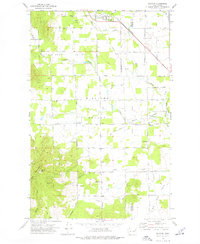
 1973 Tumtum1977 Print · USGSStevens County in the early seventies shows the rural community of Tumtum and the Spokane Indian Reservation boundary. Genealogists and hikers can locate the Tumtum Cem, the waters of Red Lake, and trails leading to Scoop Mountain.
 - 1973 Map of Ford, 1977 Print
 1973 Ford1977 Print · USGSThe rural landscape of Stevens County comes into focus in the early 1970s, showing the agricultural valley of Walkers Prairie. Genealogists and researchers can trace the community of Ford, locate St Joseph Ch, and find family-named landmarks like Happy Hill.
 - 1973 Map of Little Falls, 1977 Print
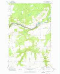 1973 Little Falls1977 Print · USGSThe Spokane River canyon and the hydroelectric infrastructure of the 1970s define this borderland between Lincoln and Stevens counties. Researchers can locate the Little Falls settlement and Plant I, or trace the rugged drainages of Tamarack Canyon and Spring Creek Canyon.
 - 1978 Map of Deer Lake, 1981 Print
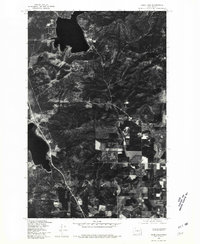 1978 Deer Lake1981 Print · USGSStevens County lake country appears in sharp detail in the late 1970s, showing the early footprints of shoreline development. Trace the roads and clearings around Deer Lake, Loon Lake, and the timbered slopes of Deer Lake Mtn.
End of results
Showing maps 1-9 of 9
Top cities of Stevens County
- Colville historical maps
- Chewelah historical maps
- Kettle Falls historical maps
- Northport historical maps
- Springdale historical maps
- Marcus historical maps
Frequently asked questions
- What are the different types of historical maps available for Stevens County?
- What is the oldest map of Stevens County?
- Where can I purchase historical maps of Stevens County for my home or office?
- Where can I download high-res historical maps of Stevens County?
- Are there historical topographic maps available for Stevens County?
- Is there historical aerial imagery available for Stevens County?
- Where are historical maps of Stevens County sourced from?