1980s Maps of Stevens County, Washington
Explore 24 historic maps of Stevens County from the 1980s. These maps offer a rare glimpse into what life looked like during the 1980s — showing old roads, neighborhoods, homes, and landmarks that have changed or disappeared over time.
Whether you're researching your family's past, planning a metal detecting trip, or studying how Stevens County's landscape evolved across the 1980s, these high-resolution maps are a powerful tool for exploring the history of this region.
- Focus on a specific era: All maps on this page are from the 1980s, giving you a focused view of this time period.
- See what’s changed: Compare century-old streets, trails, and buildings to today's modern landscape using overlays and satellite layers.
- Research with precision: Use these maps for genealogy, historical research, land use analysis, or educational projects.
- View, download, or print: Maps are fully viewable online in high resolution, and can be downloaded or printed for your own records.
Start exploring Stevens County's history through authentic maps from the 1980s. This is your window into the past.
Stevens County, WA maps
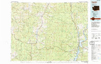
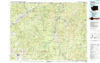
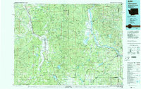
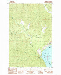
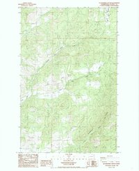
(24)- 1980 Map of Calispell Peak, 1981 Print
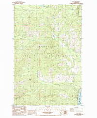
 1980 Calispell Peak1981 Print · USGSThe Selkirk Mountains of northeastern Washington are shown here in the early eighties, centered on the high refuge lands and peaks. Genealogists and hikers can trace family-named sites like Pal Moore Meadow and Hartill Meadows, or locate the Merikay Mine near the county line.
 - 1983 Map of Coulee Dam
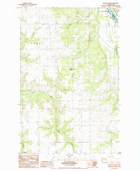
 1983 Coulee Dam1983 Print · USGSThe high plateau and deep coulees of central Washington are captured here in the early eighties, centered on the massive Franklin D Roosevelt Lake and the towns of Coulee Dam and Grand Coulee. Researchers can trace the Burlington Northern rail corridor through old stops at Govan and Mondovi or locate the historic Fort Spokane.2 unique versions available
 - 1984 Map of Republic
 1984 Republic1984 Print · USGSThe Okanogan Highlands and Kettle River Range are shown in the mid-1980s, documenting a landscape shaped by mining and timber. Genealogists can trace old settlements like Bodie and Toroda, or locate historic workings such as the Knob Hill Mine and First Thought Mine.
 - 1984 Map of Colville
 1984 Colville1984 Print · USGSNortheastern Washington and the Idaho borderlands are documented here in the mid-1980s as the regional economy balanced forestry and mineral extraction. Genealogists and researchers can trace dozens of mountain mining operations like Van Stone Mine alongside timber settlements such as Metaline Falls and Aladdin.2 unique versions available
 - 1984 Map of Nespelem
 1984 Nespelem1984 Print · USGSThe Colville Indian Reservation and the Columbia River valley are shown here in the mid-1980s, just as modern recreation was shaping the landscape. Genealogists and researchers can locate old communities like Inchelium and Keller or trace mining history at the Germania Mine.
 - 1984 Map of Chewelah
 1984 Chewelah1984 Print · USGSNortheastern Washington in the mid-1980s is documented here through its valley settlements and mountain mining districts. Researchers can trace the Burlington Northern line between Springdale and Addy, or locate historical operations like the Wells Fargo Mine and Keystone Mine.
 - 1985 Map of Ninemile Flat
 1985 Ninemile Flat1985 Print · USGSThe Colville Indian Reservation meets the Columbia River in Ferry County during the 1980s. Local researchers can trace the waters of Franklin D Roosevelt Lake and find landmarks like Ninemile Falls and Ninemile Flat.3 unique versions available
 - 1985 Map of Blackhorse Canyon
 1985 Blackhorse Canyon1985 Print · USGSHuckleberry Mountain and the Harvey Creek drainage are documented in the mid-1980s, showing a landscape of forest trails and water management. Researchers can trace land use through features like the Smith Meadows Ditch, a Borrow Pit, and a remote Cem.2 unique versions available
 - 1985 Map of Miller Mtn.
 1985 Miller Mtn.1985 Print · USGSCrossing the Columbia River in the mid-1980s, this survey captures the intersection of the Colville Indian Reservation and Spokane Indian Reservation. Trace the rugged shoreline of Franklin D Roosevelt Lake to find Enterprise Camp and Miller Mtn.2 unique versions available
 - 1985 Map of Cedonia
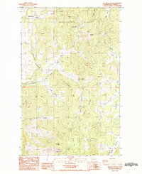
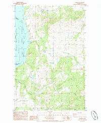
 1985 Cedonia1985 Print · USGSThe Columbia River corridor north of Grand Coulee Dam appears here in the mid-1980s as the vast Franklin D. Roosevelt Lake. You can trace the boundary between the Colville Indian Reservation and Stevens County, locating the Longstreet Mine and the small communities of Cedonia and Covada.2 unique versions available
 - 1985 Map of Wellington Peak
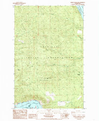
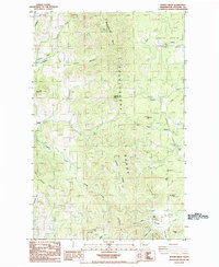
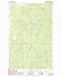
 1985 Wellington Peak1985 Print · USGSThe high ridges of Stevens County appear here in the mid-1980s, revealing a landscape of remote mines and early settlements. Researchers can locate the Waterloo School, a local Cem, and productive sites like the Silver Summit Mine.2 unique versions available
 - 1985 Map of Kewa
 1985 Kewa1985 Print · USGSIn the mid-eighties, the rugged interior of the Colville Indian Reservation overlooks the Columbia River. Local researchers can trace family roots at Kewa Cem or locate mineral prospects near Middle Mountain and Fish Lake.2 unique versions available
 - 1985 Map of Inkster Lake
 1985 Inkster Lake1985 Print · USGSLincoln County, Washington, at the edge of the Spokane Indian Reservation in the mid-1980s shows a landscape of high plateaus and deep river canyons. Researchers can locate the Cemetery near Egypt, the North Star Grange, and the small settlement of Larene.
 - 1985 Map of Rice
 1985 Rice1985 Print · USGSThe Columbia River valley in the mid-1980s reveals a landscape shaped by the reservoir and traditional ranching. Local historians can trace family landmarks and industrial sites like the Big Lake Mine, Staehly Ranch, and the Rice community center.2 unique versions available
 - 1985 Map of Mc Coy Lake
 1985 Mc Coy Lake1985 Print · USGSThe confluence of the Spokane River and Roosevelt Lake is captured in the mid-eighties, showing a mix of tribal lands and industrial activity. Trace local mining history at the Spokane Molybdenum Mine or locate old homesteads near Pitney and the local Cem.
 - 1985 Map of Johnny George Mtn
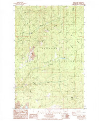
 1985 Johnny George Mtn1985 Print · USGSFerry County, Washington, is captured in the mid-eighties as a landscape of high ridges and vast reservoir waters. Researchers can trace the rugged boundaries of the Colville Indian Reservation and locate landmarks like Johnny George Mtn and Bear Spring.
 - 1985 Map of Hunters
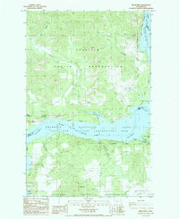
 1985 Hunters1985 Print · USGSStevens County settlements sit along the Columbia River during the mid-1980s as the regional landscape balances recreation and industry. Researchers can trace the boundaries of the Spokane Indian Reservation and locate landmarks like the H and B Mine and Fruitland.2 unique versions available
 - 1985 Map of Benjamin Lake
 1985 Benjamin Lake1985 Print · USGSThe Spokane River and the northern reaches of the Columbia River drainage are captured here in the mid-1980s. Researchers can trace the industrial activity at the Sherwood Mine, the boundaries of the Spokane Indian Reservation, and remote landmarks like Cayuse Mountain.
 - 1985 Map of Fort Spokane
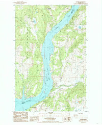
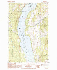
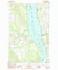
 1985 Fort Spokane1985 Print · USGSThe confluence of the Columbia and Spokane Rivers is captured here in the mid-1980s, documenting the intersection of tribal lands and federal recreation areas. Researchers can locate the historic Fort Spokane site, the settlement of Miles, and landmarks like Castle Rock.
 - 1985 Map of Inchelium
 1985 Inchelium1985 Print · USGSIn the mid-1980s, this portion of the Columbia River valley highlights the intersection of the Colville Indian Reservation and the rising waters of Franklin D Roosevelt Lake. Researchers can trace the river's influence on local life through the Gifford Ferry, the Colville Indian Subagency, and the site of the former settlement at Impach.2 unique versions available
 - 1985 Map of Kentry Ridge
 1985 Kentry Ridge1985 Print · USGSThe Huckleberry Range of Stevens County is captured in the mid-1980s, showing a high-country landscape of mining and timber. Researchers can trace historic operations at the Aquila Mine and Daisy Mine or locate the old settlement at Arzina.2 unique versions available
 - 1985 Map of Turtle Lake
 1985 Turtle Lake1985 Print · USGSThe Spokane Indian Reservation in the mid-1980s reveals a landscape of industrial mining and rugged ridgelines. Researchers can trace the extensive operations of the Sherwood Mine and Midnight Mine or locate landmarks like the lookout tower on Wellpinit Mtn.
 - 1985 Map of Adams Mtn
 1985 Adams Mtn1985 Print · USGSStevens County mining country is captured in the mid-1980s, revealing a landscape of high-altitude claims and creek-side settlements. Researchers can trace historic operations at the Cleveland Mine, the small community of Turk, and the border of the Spokane Indian Reservation.2 unique versions available
 - 1987 Map of Spokane
 1987 Spokane1987 Print · USGSGreater Spokane and its surrounding prairies are captured in the late 1980s as the region solidified its role as a regional hub. Researchers can trace family sites near Medical Lake, military life at Fairchild Air Force Base, and rural settlements like Peone and Chattaroy.
End of results
Showing maps 1-24 of 24
Top cities of Stevens County
- Colville historical maps
- Chewelah historical maps
- Kettle Falls historical maps
- Northport historical maps
- Springdale historical maps
- Marcus historical maps
Frequently asked questions
- What are the different types of historical maps available for Stevens County?
- What is the oldest map of Stevens County?
- Where can I purchase historical maps of Stevens County for my home or office?
- Where can I download high-res historical maps of Stevens County?
- Are there historical topographic maps available for Stevens County?
- Is there historical aerial imagery available for Stevens County?
- Where are historical maps of Stevens County sourced from?