1990s Maps of Thurston County, Washington
Explore 20 historic maps of Thurston County from the 1990s. These maps offer a rare glimpse into what life looked like during the 1990s — showing old roads, neighborhoods, homes, and landmarks that have changed or disappeared over time.
Whether you're researching your family's past, planning a metal detecting trip, or studying how Thurston County's landscape evolved across the 1990s, these high-resolution maps are a powerful tool for exploring the history of this region.
- Focus on a specific era: All maps on this page are from the 1990s, giving you a focused view of this time period.
- See what’s changed: Compare century-old streets, trails, and buildings to today's modern landscape using overlays and satellite layers.
- Research with precision: Use these maps for genealogy, historical research, land use analysis, or educational projects.
- View, download, or print: Maps are fully viewable online in high resolution, and can be downloaded or printed for your own records.
Start exploring Thurston County's history through authentic maps from the 1990s. This is your window into the past.
Thurston County, WA maps
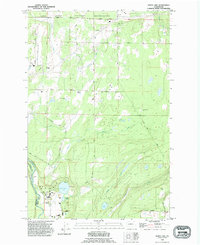
(20)- 1990 Map of Vail, 1995 Print
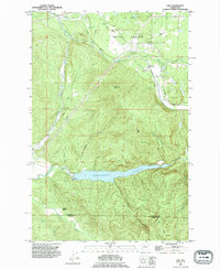 1990 Vail1995 Print · USGSThe timber and rail corridors of Thurston County come into focus in the 1990s as the Vail Railway winds through Ruth Prairie. Researchers can trace the industrial footprint of Vail through its logging roads and the massive Skookumchuck Reservoir.
 - 1990 Map of Tenalquot Prairie, 1995 Print
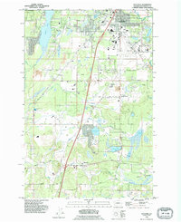
 1990 Tenalquot Prairie1995 Print · USGSThurston County’s prairie and river landscapes appear in the early nineties, showing the expansive Fort Lewis Military Reservation and the growing community of Yelm. Trace family history and land use through labels like Burnham Ranch, the local Cem, and the Nisqually Indian Reservation.
 - 1990 Map of Bucoda, 1995 Print
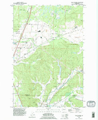
 1990 Bucoda1995 Print · USGSThe Tenino and Bucoda area in the 1990s shows a landscape of timbered ridges and active valley mining. Researchers can trace the legacy of the Black Prince Mine, explore the Forest Cemetery, and follow the Old Railroad Grade through the Hanaford Valley.
 - 1990 Map of Mc Kenna, 1995 Print
 1990 Mc Kenna1995 Print · USGSThurston and Pierce Counties come together along the river in the early 1990s as military and civilian landscapes intersect. Researchers can trace the layout of the Fort Lewis Military Reservation or locate family roots near Yelm and the ruins at McKenna.
 - 1990 Map of Bald Hill, 1995 Print
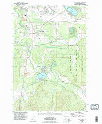
 1990 Bald Hill1995 Print · USGSThurston County’s lake country and river valleys are documented here in the mid-1990s, where the Nisqually and Deschutes Rivers frame a landscape of water and timber. Local historians can trace the boundaries of Elbow Lake State Park or locate the cascades at Deschutes Falls and the landmark Fossil Rock.
 - 1990 Map of Eatonville, 1995 Print
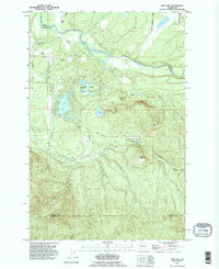
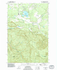
 1990 Eatonville1995 Print · USGSEatonville and the Nisqually River valley appear here in the final decade of the millennium, defined by heavy timber research and massive hydro projects. Genealogists and local historians can trace the development of Alder, locate the Swanson Airport, and explore the bounds of the Charles Lathrop Pack Experimental Forest.
 - 1990 Map of Harts Lake, 1995 Print
 1990 Harts Lake1995 Print · USGSPierce County in the 1990s is captured here as a landscape of military reservations and glacial waters. Genealogists and researchers can trace the rural road network connecting Harts Lake, the Fort Lewis Military Reservation, and Centralia Dam.
 - 1990 Map of Lake Lawrence, 1995 Print
 1990 Lake Lawrence1995 Print · USGSThurston and Lewis counties come together in this 1990s record of a landscape shaped by logging and highland ranching. Genealogists and local historians can trace the Old Grade Railroad, locate the Roundtree Cabin, and identify family sites like Reichel Ranch.
 - 1990 Map of Maytown, 1995 Print
 1990 Maytown1995 Print · USGSThurston County settlement and industry are on display in the 1990s as suburban growth meets the rail lines of Maytown. Trace the intersection of the Burlington Northern railroad, the Olympia Airport, and Millersylvania State Park.
 - 1990 Map of East Olympia, 1995 Print
 1990 East Olympia1995 Print · USGSThurston County’s prairie and timber lands are captured here in the 1990s as suburban growth reached toward the Deschutes River. Genealogists and historians can trace rail history near Western Junction or explore old settlements like Plumb and Fir Tree.
 - 1990 Map of Violet Prairie, 1995 Print
 1990 Violet Prairie1995 Print · USGSThurston and Lewis counties come together in this 1990s survey of the prairie landscapes south of the state capital. Genealogists can trace early mining operations at Monarch Mine or locate families near Bucoda and Violet.
 - 1991 Map of Tacoma
 1991 Tacoma1991 Print · USGSThe South Sound and Tacoma waterfront appear here in the early nineties, showing a landscape defined by deep-water inlets and massive federal installations. Researchers can trace the development of Lakewood Center or locate the historic rail lines of the Burlington Northern Railroad and Union Pacific Railroad.
 - 1992 Map of Chehalis River, 1993 Print
 1992 Chehalis River1993 Print · USGSThe Chehalis River valley and the timberlands of the Black Hills are captured here in the early nineties. Researchers can trace rail-and-river history through Montesano and Raymond, or locate the unique Mima Mounds and Bordeaux.2 unique versions available
 - 1997 Map of Tumwater, 2000 Print
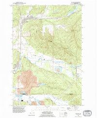
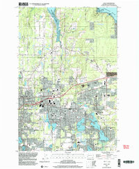
 1997 Tumwater2000 Print · USGSThe southern reaches of the Puget Sound come into focus in the late nineties, showcasing the growth of Olympia and Tumwater. Genealogists and local historians can locate early institutions like the McLane Grange Hall, Olympia Jr Academy, and the waterfront Countryside Beach settlement.
 - 1997 Map of Squaxin Island, 2003 Print
 1997 Squaxin Island2003 Print · USGSThe southern Puget Sound reaches of Mason and Thurston counties appear here in the late nineties, showing a landscape defined by deep inlets and island life. Researchers can locate the Squaxin Island Indian Reservation, the Boston Harbor Sch, and waterfront settlements like Arcadia and Carlyon Beach.
 - 1997 Map of Mc Neil Island, 2003 Print
 1997 Mc Neil Island2003 Print · USGSThe islands of the southern Sound are captured here during the late nineties, featuring the expansive McNeil Island Corrections Center. Trace local landmarks like the Hillcrest Cem, Old Schoolhouse Park, and the Steilacoom Ferry route.
 - 1997 Map of Lacey, 2003 Print
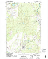
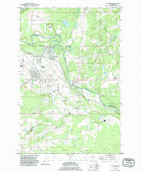
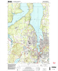
 1997 Lacey2003 Print · USGSThe Puget Sound shoreline and the growing suburbs of Thurston County come into focus during the late nineties. Genealogists and historians can trace the development of Lacey through its many schools and cemeteries like Ruddell Pioneer Cemetery or locate the old industrial footprint of Union Mill.
 - 1997 Map of Nisqually, 2003 Print
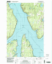
 1997 Nisqually2003 Print · USGSThe Nisqually River delta and the southern reaches of Puget Sound are shown here in the late 1990s as a complex mix of military, conservation, and historical sites. Researchers can locate the Fort Nisqually 1833 Historical Site, the Sequalitchew Cemetery, and the Nisqually Station.
 - 1997 Map of Longbranch, 2003 Print
 1997 Longbranch2003 Print · USGSThe South Puget Sound landscape in the late nineties showcases a complex network of inlets and peninsulas before recent coastal developments. Researchers can trace historic shorelines and landmarks from Longbranch and Ballow to the Woodard Bay Conservation Area and Devils Head.
 - 1998 Map of Eatonville, 2003 Print
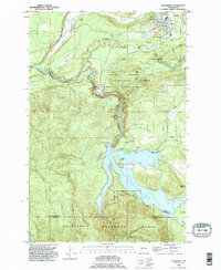
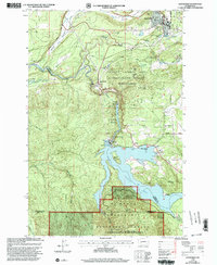 1998 Eatonville2003 Print · USGSThe Nisqually River corridor is shown here as it appeared in the late nineties, defined by the hydroelectric developments at Alder Lake and La Grande Reservoir. Researchers can trace the timber and research history of the Charles Lathrop Pack Demonstration Forest or locate landmarks like the Pack Lookout Tower and Little Mashel Falls.
End of results
Showing maps 1-20 of 20
Top cities of Thurston County
- Olympia historical maps
- Lacey historical maps
- Tumwater historical maps
- Yelm historical maps
- Grand Mound historical maps
- North Yelm historical maps
See more
Frequently asked questions
- What are the different types of historical maps available for Thurston County?
- What is the oldest map of Thurston County?
- Where can I purchase historical maps of Thurston County for my home or office?
- Where can I download high-res historical maps of Thurston County?
- Are there historical topographic maps available for Thurston County?
- Is there historical aerial imagery available for Thurston County?
- Where are historical maps of Thurston County sourced from?