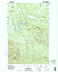
1990 Map of Bald Hill
USGS Topo · Published 1995About this map
The Nisqually River and the Deschutes River define the hydraulic character of this corner of Thurston County in the 1990s. The landscape is heavily marked by glacially formed lakes and wetlands, including Clear Lake, Elbow Lake, and the distinctive Parsnip Swamp. Conservation and recreation areas are well-established, with Elbow Lake State Park and Deschutes Falls County Park protecting the area's most prominent natural landmarks. The map illustrates a transition from the agricultural lowlands near the river bends to the rising elevations of Bald Hill and Green Hill. Human impact on the hydrology is visible through the Yelm Ditch and various unnamed pits, while local travel is managed via a network of rural routes like Longmire Road and Bald Hill Road. This survey provides a clear look at the intersection of three counties—Pierce, Thurston, and Lewis—amidst a terrain of creeks like Tanwax Creek and Lackamas Creek.
Find a feature on this map
33 named features on this map. Tap any name to fly to it.
Don’t see what you’re looking for? This feature index may not catch every label — zoom into the map to look around manually.
Map Details
Editions of this 1990 Bald Hill Map
This is the sole edition of this map. No revisions or reprints were ever made.
Other maps of this area

1916 · Chehalis
USGS Topo · 1:125,000

1937 · Eatonville
USGS Topo · 1:125,000

1941 · Tanwax Lake
USGS Topo · 1:62,500

1943 · Willapa
USGS Topo · 1:62,500

1944 · Yelm
USGS Topo · 1:62,500

1944 · Ohop Valley
USGS Topo · 1:62,500

1949 · Ohop Valley
USGS Topo · 1:62,500

1949 · Yelm
USGS Topo · 1:62,500

1953 · Hoquiam
USGS Topo · 1:250,000

1954 · Onalaska
USGS Topo · 1:62,500