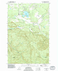
1990 Map of Lake Lawrence
USGS Topo · Published 1995About this map
Lake Lawrence and the surrounding plateau of Smith Prairie define the northern portion of this landscape, where recreation and agriculture meet. The map reveals a transition from the level terrain of Vail Loop Road to the steep rises of Porcupine Ridge and Clam Mountain. A small Cem near the Deschutes River and the isolated Roundtree Cabin provide evidence of early family holdings and rural settlements.
Find a feature on this map
42 named features on this map. Tap any name to fly to it.
Don’t see what you’re looking for? This feature index may not catch every label — zoom into the map to look around manually.
Map Details
Editions of this 1990 Lake Lawrence Map
This is the sole edition of this map. No revisions or reprints were ever made.
Other maps of this area

1916 · Chehalis
USGS Topo · 1:125,000

1937 · Eatonville
USGS Topo · 1:125,000

1941 · Tanwax Lake
USGS Topo · 1:62,500

1943 · Willapa
USGS Topo · 1:62,500

1944 · Yelm
USGS Topo · 1:62,500

1944 · Ohop Valley
USGS Topo · 1:62,500

1949 · Ohop Valley
USGS Topo · 1:62,500

1949 · Yelm
USGS Topo · 1:62,500

1953 · Hoquiam
USGS Topo · 1:250,000

1954 · Onalaska
USGS Topo · 1:62,500