1960s Maps of Pullman, Washington
Explore 4 historic maps of Pullman from the 1960s. These maps offer a rare glimpse into what life looked like during the 1960s — showing old roads, neighborhoods, homes, and landmarks that have changed or disappeared over time.
Whether you're researching your family's past, planning a metal detecting trip, or studying how Pullman's landscape evolved across the 1960s, these high-resolution maps are a powerful tool for exploring the history of this region.
- Focus on a specific era: All maps on this page are from the 1960s, giving you a focused view of this time period.
- See what’s changed: Compare century-old streets, trails, and buildings to today's modern landscape using overlays and satellite layers.
- Research with precision: Use these maps for genealogy, historical research, land use analysis, or educational projects.
- View, download, or print: Maps are fully viewable online in high resolution, and can be downloaded or printed for your own records.
Start exploring Pullman's history through authentic maps from the 1960s. This is your window into the past.
Pullman, WA maps
(4)- 1964 Map of Viola, 1965 Print
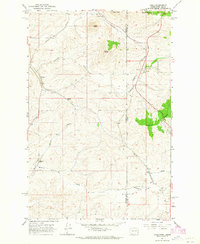 1964 Viola1965 Print · USGSThe Palouse hills along the Washington and Idaho border come alive in the mid-1960s, showing a landscape defined by timbered buttes and vital rail lines. Genealogists and rail historians can trace the paths of the Northern Pacific through rural stops like Fallon, Viola, and Whelan.2 unique versions available
 - 1964 Map of Moscow West, 1965 Print
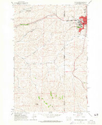 1964 Moscow West1965 Print · USGSThe Idaho-Washington border comes alive in the mid-1960s, centered on the university town of Moscow and its rail connections. Researchers can trace the junction of the Union Pacific and Great Northern railroads or locate the University of Idaho campus and the old Drive-in Theater.3 unique versions available
 - 1964 Map of Albion, 1965 Print
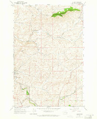 1964 Albion1965 Print · USGSWhitman County agriculture and transportation are captured here in the mid-1960s, showing the vital rail-and-river network of the Palouse. Genealogists can locate family landmarks like Mt Olivet Cem, the local Grange Hall, and the small siding at Kitzmiller.
 - 1964 Map of Pullman, 1965 Print
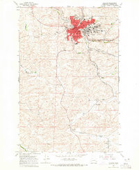 1964 Pullman1965 Print · USGSPullman and the surrounding Palouse hills are captured here in the mid-sixties, a period of significant academic and agricultural activity. Researchers can trace the rail lines of the Union Pacific through small sidings and settlements like Staley, Busby, and Chambers.3 unique versions available
End of results
Showing maps 1-4 of 4
Top cities near Pullman
- Moscow historical maps
- Colfax historical maps
- Palouse historical maps
- Genesee historical maps
- Albion historical maps
- Colton historical maps
See more
Top neighborhoods of Pullman
Frequently asked questions
- What are the different types of historical maps available for Pullman?
- What is the oldest map of Pullman?
- Where can I purchase historical maps of Pullman for my home or office?
- Where can I download high-res historical maps of Pullman?
- Are there historical topographic maps available for Pullman?
- Is there historical aerial imagery available for Pullman?
- Where are historical maps of Pullman sourced from?