1990s Maps of Boone County, West Virginia
Explore 11 historic maps of Boone County from the 1990s. These maps offer a rare glimpse into what life looked like during the 1990s — showing old roads, neighborhoods, homes, and landmarks that have changed or disappeared over time.
Whether you're researching your family's past, planning a metal detecting trip, or studying how Boone County's landscape evolved across the 1990s, these high-resolution maps are a powerful tool for exploring the history of this region.
- Focus on a specific era: All maps on this page are from the 1990s, giving you a focused view of this time period.
- See what’s changed: Compare century-old streets, trails, and buildings to today's modern landscape using overlays and satellite layers.
- Research with precision: Use these maps for genealogy, historical research, land use analysis, or educational projects.
- View, download, or print: Maps are fully viewable online in high resolution, and can be downloaded or printed for your own records.
Start exploring Boone County's history through authentic maps from the 1990s. This is your window into the past.
Boone County, WV maps
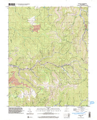
(11)- 1996 Map of Belle, 2000 Print
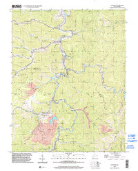
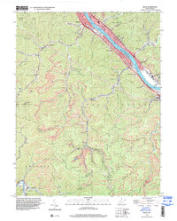 1996 Belle2000 Print · USGSThe industrial corridor of the Kanawha River comes into sharp focus during the mid-nineties, showing the integration of rail, water, and mining. Genealogists and historians can trace family locations through numerous sites like Wrightsville Cem, Winifrede, and Lens Creek Ch.
 - 1996 Map of Wharton, 2002 Print
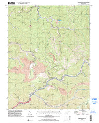
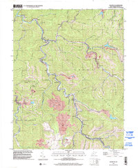 1996 Wharton2002 Print · USGSBoone County's coal-heavy river valleys are captured here in the 1990s, showing the dense network of mining and hollow settlements. Genealogists can trace family names at Mid Ferrell Cem or locate community hubs like Elizabeth Ch and the town of Bob White.
 - 1996 Map of Dorothy, 2002 Print
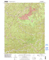
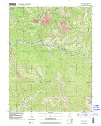 1996 Dorothy2002 Print · USGSCoal mining and rail history dominate this West Virginia landscape in the late 1990s, where extraction infrastructure meets deep Appalachian hollows. Genealogists and researchers can trace local family sites like Union Cemetery, Township High School, and the Horse Creek Church.
 - 1996 Map of Sylvester, 2002 Print
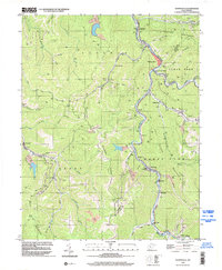
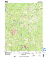 1996 Sylvester2002 Print · USGSThe Big Coal River valley in the mid-nineties shows a landscape of river-bottom towns and ridge-top industry. Trace family roots at Foster Cem or locate old community centers like Seth, Prenter, and Orgas near the Big Coal River.
 - 1996 Map of Clothier, 2002 Print
 1996 Clothier2002 Print · USGSBoone and Logan Counties reveal a landscape of coal production and mountain settlements in the mid-nineties. Genealogists and historians can trace community roots through numerous family landmarks like Adkins Cem and the Sharples High Sch.
 - 1996 Map of Amherstdale, 2002 Print
 1996 Amherstdale2002 Print · USGSThe West Virginia coalfields are captured here in the mid-nineties, showing the intensive industrial landscape of the Buffalo Creek valley. Trace the legacy of mining towns like Amherstdale and Accoville alongside deep Mine works and the CSX rail lines.
 - 1996 Map of Mud, 2002 Print
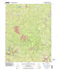
 1996 Mud2002 Print · USGSBoone County and the surrounding coalfields are captured in the mid-1990s, showing a landscape shaped by narrow hollows and industry. Researchers can trace family roots through several upland burial sites like Baisden Cem and Stanley Cem, or locate the old Stanley Sch and Mud Sch.
 - 1996 Map of Whitesville, 2002 Print
 1996 Whitesville2002 Print · USGSThe West Virginia coalfields near the Boone and Raleigh county line are shown here in the late nineties as a dense network of valley settlements. Researchers can locate family landmarks like Jarrells Cem and trace the rail-and-river geography of Whitesville, Lindytown, and Montcoal.
 - 1996 Map of Lorado, 2003 Print
 1996 Lorado2003 Print · USGSThe West Virginia coalfields are captured in detail during the late nineties, showing the industrial density of the Logan and Wyoming county borders. Genealogists and historians can trace the mining settlements of Lorado, Craneco, and Pardee along the banks of Buffalo Creek.
 - 1996 Map of Madison, 2003 Print
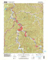 1996 Madison2003 Print · USGSBoone County's river valleys and coal-country rail lines are frozen in time here just before the millennium. Researchers can trace family history through dozens of local burial sites like Memory Gardens (Cem) or find the industrial pulse at Quinland and Uneeda.
 - 1996 Map of Williams Mountain, 2003 Print
 1996 Williams Mountain2003 Print · USGSBoone County coal country in the mid-nineties shows a landscape defined by steep ridges and narrow hollows. Genealogists and historians can locate remote family landmarks like Jarrells Cem and Atha Chapel alongside the massive Strip Mine works near Peytona.
End of results
Showing maps 1-11 of 11
Top cities of Boone County
Frequently asked questions
- What are the different types of historical maps available for Boone County?
- What is the oldest map of Boone County?
- Where can I purchase historical maps of Boone County for my home or office?
- Where can I download high-res historical maps of Boone County?
- Are there historical topographic maps available for Boone County?
- Is there historical aerial imagery available for Boone County?
- Where are historical maps of Boone County sourced from?