Old Maps of Alpha Base Camp, West Virginia
Explore 18 old maps of Alpha Base Camp, spanning from 1891 to today. These high-resolution historic maps reveal how streets, neighborhoods, landmarks, and natural features evolved over time — perfect for genealogy, metal detecting, research, and local history exploration.
What you can do with these maps:
- See how Alpha Base Camp changed over time: Compare historical maps to modern-day views to trace roads, homesites, rail lines & more.
- View detailed metadata: Each map includes creators, publishers, year, scale, and archive source.
- Overlay maps with satellite & LiDAR: Visualize the past alongside modern tools to explore terrain & human change.
- Trusted historical sources: Maps sourced from the USGS, Library of Congress, and other archives.
- Access maps your way: View online, download high-res files, or order prints for personal or research use.
Start exploring old maps of Alpha Base Camp to uncover forgotten places, hidden landmarks, and the deep history beneath your feet.
Alpha Base Camp, WV maps
(18)- 1891 Map of Raleigh
 1891 Raleigh1891 Print · USGSRaleigh County and the New River Gorge are captured in the late nineteenth century during the initial rise of the coal industry. Genealogists can trace family holdings along Paint Creek or locate early river settlements such as Quinnimont and Fire Creek.
 - 1897 Map of Raleigh
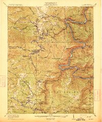
 1897 Raleigh1897 Print · USGSThe New River Gorge area at the height of the coal and rail boom comes to life on this late nineteenth-century sheet. Genealogists and historians can trace riverside rail stops like Thurmond and Glenjean, or explore the high-plateau settlement at Marshes P.O. (Trap Hill).
 - 1902 Map of Raleigh
 1902 Raleigh1902 Print · USGSRaleigh County and the New River Gorge were entering their industrial peak when this survey was conducted in the late nineteenth century. Researchers can trace the early rail network of the CHESAPEAKE AND OHIO RR through booming towns like Thurmond, Beury, and East Sewell.3 unique versions available
 - 1911 Map of Beckley
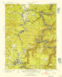
 1911 Beckley1911 Print · USGSThe coal and rail landscape of Raleigh and Fayette counties comes to life in the years before the Great War. Genealogists can trace family roots through numerous remote settlements and rural landmarks like Mount Hope, Silver Cliff School, and the winding New River.
 - 1913 Map of Beckley
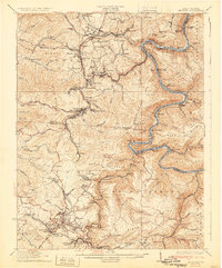
 1913 Beckley1913 Print · USGSRaleigh and Fayette counties are shown at the height of the coal era, when the New River canyon hummed with steam power and industry. Genealogists can locate family homesteads near vanished landmarks like the Krise PO Glade, Excelsior School, and the Lanark Sta railroad stop.3 unique versions available
 - 1929 Map of Beckley, 1954 Print
 1929 Beckley1954 Print · USGSRaleigh and Fayette counties are shown in the late 1920s as coal and rail lines transformed the New River Gorge. Genealogists can trace family roots through numerous mining settlements like Minden or Thurmond and identify remote landmarks such as Brooklyn Finlow PO and Miles Sch.2 unique versions available
 - 1932 Map of Beckley
 1932 Beckley1932 Print · USGSThe West Virginia coalfields are shown here at their industrial height in the early 1930s, centered on the rugged gorge of the New River. Genealogists and historians can trace the rail-and-river network connecting towns like Thurmond and Glen Jean or locate rural landmarks such as Brooklyn Finlow PO and Estuary School.2 unique versions available
 - 1955 Map of Bluefield
 1955 Bluefield1955 Print · USGSThe Central Appalachian borderlands come alive in the mid-fifties, showing the coal and rail networks connecting Bluefield to Beckley. Researchers can trace the industrial landscape of the New River Ordnance Plant and the terrain of Burkes Garden.
 - 1957 Map of Bluefield, 1967 Print
 1957 Bluefield1967 Print · USGSThe heart of Central Appalachia in the mid-fifties is defined by the winding rail lines and river valleys of the coalfields. Researchers can trace the industrial footprints of towns like Welch and Princeton or locate landmarks such as the Bluestone Reservoir and Claytor Lake.2 unique versions available
 - 1961 Map of Bluefield
 1961 Bluefield1961 Print · USGSThe coalfields and mountain ridges of southern West Virginia and southwest Virginia are captured in the early sixties. Genealogists can trace family ties through rail-linked towns like Princeton and Richlands or along the shores of Bluestone Reservoir.
 - 1969 Map of Thurmond, 1973 Print
 1969 Thurmond1973 Print · USGSFayette County coal country is shown in detail during the late sixties, where the winding New River corridor dictates the path of the Chesapeake and Ohio railroad. Genealogists and historians can trace the foundations of mining towns like Minden and Thurmond, or locate old landmarks like Calvin Ch and Dowdy Bluff.3 unique versions available
 - 1982 Map of Beckley, 1984 Print
 1982 Beckley1984 Print · USGSSouthern West Virginia coal country is captured here in the early eighties as industrial heritage met new wilderness protections. Genealogists and historians can trace the rail-linked communities of Beckley, Oak Hill, and the coal camps near Macdonald.
 - 1997 Map of Thurmond, 2001 Print
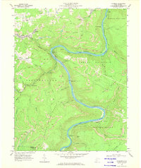
 1997 Thurmond2001 Print · USGSThe New River Gorge coal country is captured here during the late twentieth century, showing a landscape defined by industry and steep terrain. Genealogists and historians can trace the riverside settlements of Thurmond, Beury, and Sewell alongside coal-era infrastructure like strip mines and the Conveyor Tipple.
 - 2011 Map of Thurmond, 2011 Print
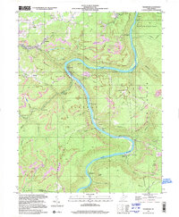
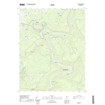
 2011 Thurmond2011 Print · USGSCovers Alpha Base Camp, including Oak Hill, Thurmond, and other nearby areas
 - 2014 Map of Thurmond, 2014 Print
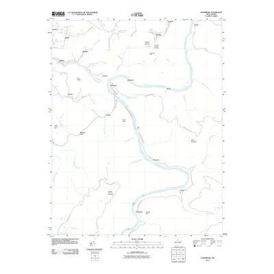
 2014 Thurmond2014 Print · USGSCovers Alpha Base Camp, including Oak Hill, Thurmond, and other nearby areas
 - 2016 Map of Thurmond, 2016 Print
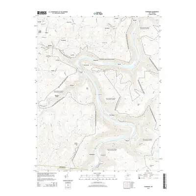
 2016 Thurmond2016 Print · USGSCovers Alpha Base Camp, including Oak Hill, Thurmond, and other nearby areas
 - 2019 Map of Thurmond, 2019 Print
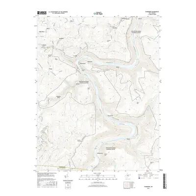
 2019 Thurmond2019 Print · USGSCovers Alpha Base Camp, including Oak Hill, Thurmond, and other nearby areas
 - 2023 Map of Thurmond, 2023 Print
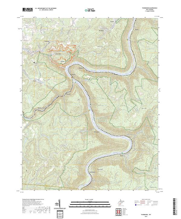 2023 Thurmond2023 Print · USGSThe New River Gorge comes alive in this contemporary record of its deep canyons and riverside rail towns. Genealogists and historians can trace the foundations of Sewell, Beury, and Thurmond along the CSX corridor and the winding river banks.
End of results
Showing maps 1-18 of 18
Top cities near Alpha Base Camp
- Beckley historical maps
- Oak Hill historical maps
- Fayetteville historical maps
- Hinton historical maps
- Ansted historical maps
- Mount Hope historical maps
See more
Top neighborhoods of Alpha Base Camp
- Subcamp A1 historical maps
- Subcamp A2 historical maps
- Subcamp A3 historical maps
- Subcamp A4 historical maps
Frequently asked questions
- What are the different types of historical maps available for Alpha Base Camp?
- What is the oldest map of Alpha Base Camp?
- Where can I purchase historical maps of Alpha Base Camp for my home or office?
- Where can I download high-res historical maps of Alpha Base Camp?
- Are there historical topographic maps available for Alpha Base Camp?
- Is there historical aerial imagery available for Alpha Base Camp?
- Where are historical maps of Alpha Base Camp sourced from?