1960s Maps of Mason County, West Virginia
Explore 15 historic maps of Mason County from the 1960s. These maps offer a rare glimpse into what life looked like during the 1960s — showing old roads, neighborhoods, homes, and landmarks that have changed or disappeared over time.
Whether you're researching your family's past, planning a metal detecting trip, or studying how Mason County's landscape evolved across the 1960s, these high-resolution maps are a powerful tool for exploring the history of this region.
- Focus on a specific era: All maps on this page are from the 1960s, giving you a focused view of this time period.
- See what’s changed: Compare century-old streets, trails, and buildings to today's modern landscape using overlays and satellite layers.
- Research with precision: Use these maps for genealogy, historical research, land use analysis, or educational projects.
- View, download, or print: Maps are fully viewable online in high resolution, and can be downloaded or printed for your own records.
Start exploring Mason County's history through authentic maps from the 1960s. This is your window into the past.
Mason County, WV maps
(15)- 1960 Map of Huntington
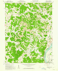
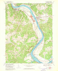
 1960 Huntington1960 Print · USGSThe tri-state river valley thrived in the late fifties as a hub of heavy industry and Appalachian rail transit. Genealogists and historians can trace the connection between river towns like Ashland and Portsmouth or locate family homesteads near Coleman Ridge.
 - 1960 Map of Addison, 1961 Print
 1960 Addison1961 Print · USGSGallia County and the Ohio River riverfront appear in the early sixties at a peak of coal and power production. Genealogists can trace family names through landmarks like McCarty Cem and Roush Cem or the rural settlement at Eno.4 unique versions available
 - 1960 Map of Pomeroy, 1961 Print
 1960 Pomeroy1961 Print · USGSThe riverfront towns of Pomeroy and Middleport are shown at the height of their industrial era when three major railroads still serviced the Ohio River banks. Genealogists can trace family landmarks like Sacred Heart Ch, St Josephs Cem, and the County Fairgrounds.4 unique versions available
 - 1960 Map of Chester, 1962 Print
 1960 Chester1962 Print · USGSMeigs County and the Ohio River riverfront thrived in the early sixties, balancing heavy industry with rural ridge-top life. Researchers can trace ancestral lands through family sites like Nease Settlement, the Welsh Town Cem, and the Chester Hill Country Club.4 unique versions available
 - 1960 Map of Cottageville, 1962 Print
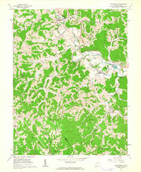 1960 Cottageville1962 Print · USGSJackson County and the surrounding ridges are seen here in the early sixties, a landscape defined by the winding Mill Creek and the Baltimore and Ohio railroad. Genealogists can locate family burial sites such as Blaine Memorial Cem and rural landmarks like Silver Valley Sch and Angerona.3 unique versions available
 - 1961 Map of Columbus
 1961 Columbus1961 Print · USGSCentral and Southern Ohio are captured here in the early sixties, as the region's industrial rail hubs and military bases reached their peak. Genealogists and historians can trace the transition from urban Columbus to rural townships along the Scioto River, locating Lockbourne USAF and old junctions like Washington Court House.
 - 1961 Map of Clarksburg
 1961 Clarksburg1961 Print · USGSThe mid-century industrial and river landscapes of West Virginia and Ohio are detailed here, centered on the Ohio River. Researchers can trace the Baltimore and Ohio rail lines connecting towns like Parkersburg, Clarksburg, and Monongah.
 - 1961 Map of Charleston
 1961 Charleston1961 Print · USGSWest Virginia's capital region and the highlands to the east are shown in detail during the early sixties. Genealogists and historians can trace rail networks like the Baltimore and Ohio RR and find early state parks such as Watoga State Park.
 - 1962 Map of Columbus
 1962 Columbus1962 Print · USGSCentral Ohio during the early sixties reveals a transition from the industrial corridors of Columbus to the forested ridges of the south. Genealogists and historians can trace the rail networks of the Baltimore & Ohio RR and find local landmarks like Washington Court House and Camp Sherman Military Reservation.
 - 1967 Map of Columbus, 1969 Print
 1967 Columbus1969 Print · USGSCentral Ohio during the late sixties serves as a vital corridor of rail and aviation, from the industrial streets of Springfield to the hangar lines of Lockbourne Air Force Base. Genealogists and researchers can trace the growth of towns like Circleville and London or locate rural landmarks such as St Paul church and the London Correctional Institution.2 unique versions available
 - 1968 Map of New Haven, 1969 Print
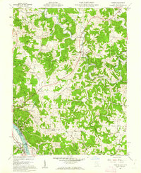
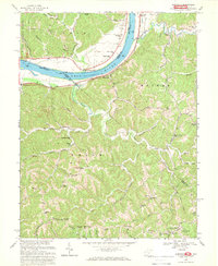
 1968 New Haven1969 Print · USGSThe Ohio River corridor comes alive in the late sixties as industrial hubs like New Haven and Graham Station sit alongside ancient landmarks. Genealogists and historians can trace family burial sites at Evergreen Cem or locate the Indian Mound and the Racine Locks and Dam.3 unique versions available
 - 1968 Map of Glenwood, 1969 Print
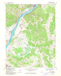
 1968 Glenwood1969 Print · USGSCabell County at the end of the sixties reveals a landscape of riverfront rail traffic and high-ridge community life. Genealogists can trace family names through landmarks like Union Ridge Cem, Bias Chapel, and schoolhouses like Central Sch.2 unique versions available
 - 1968 Map of Gallipolis, 1970 Print
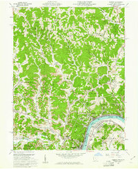
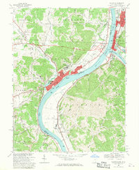 1968 Gallipolis1970 Print · USGSThe Ohio and Kanawha Rivers converge in the late sixties at the border of Ohio and West Virginia. Trace local history through the rail lines of the Baltimore and Ohio, the historic Gallia Academy, and old cemeteries like Mound Hill Cemetery.
 - 1968 Map of Cheshire, 1970 Print
 1968 Cheshire1970 Print · USGSThe Ohio River valley thrives in the late 1960s as a hub of tri-railroad transport and state-run institutions. Researchers can trace the extensive Penn Central lines or locate historic sites like Lakin State Hospital and Feniel Ch.4 unique versions available
 - 1968 Map of Apple Grove, 1970 Print
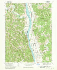 1968 Apple Grove1970 Print · USGSThe Ohio River valley in the late sixties shows a landscape defined by the Baltimore and Ohio railroad and river navigation. Genealogists can locate family landmarks like Beale Chapel, Mercers Bottom, and the Clay Sch near Ben Lomond.3 unique versions available
End of results
Showing maps 1-15 of 15
Top cities of Mason County
- Point Pleasant historical maps
- New Haven historical maps
- Mason historical maps
- Hartford City historical maps
- Henderson historical maps
- Leon historical maps
Frequently asked questions
- What are the different types of historical maps available for Mason County?
- What is the oldest map of Mason County?
- Where can I purchase historical maps of Mason County for my home or office?
- Where can I download high-res historical maps of Mason County?
- Are there historical topographic maps available for Mason County?
- Is there historical aerial imagery available for Mason County?
- Where are historical maps of Mason County sourced from?