1990s Maps of Mason County, West Virginia
Explore 4 historic maps of Mason County from the 1990s. These maps offer a rare glimpse into what life looked like during the 1990s — showing old roads, neighborhoods, homes, and landmarks that have changed or disappeared over time.
Whether you're researching your family's past, planning a metal detecting trip, or studying how Mason County's landscape evolved across the 1990s, these high-resolution maps are a powerful tool for exploring the history of this region.
- Focus on a specific era: All maps on this page are from the 1990s, giving you a focused view of this time period.
- See what’s changed: Compare century-old streets, trails, and buildings to today's modern landscape using overlays and satellite layers.
- Research with precision: Use these maps for genealogy, historical research, land use analysis, or educational projects.
- View, download, or print: Maps are fully viewable online in high resolution, and can be downloaded or printed for your own records.
Start exploring Mason County's history through authentic maps from the 1990s. This is your window into the past.
Mason County, WV maps
(4)- 1992 Map of Pomeroy, 1995 Print
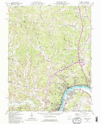 1992 Pomeroy1995 Print · USGSThe Ohio River valley bustles with riverfront activity in the early nineties, connecting the hilltop mines to the industrial waterfront. Genealogists can trace family names at Rock Springs Cem and Sacred Heart Ch or locate the old Drive-in Theater near the Mason-Pomeroy crossing.
 - 1994 Map of New Haven, 1998 Print
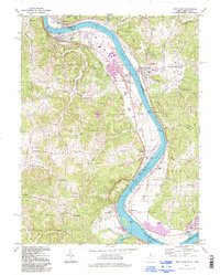 1994 New Haven1998 Print · USGSThe Ohio River corridor comes alive in the 1990s, showcasing the industrial and maritime infrastructure of Mason and Meigs counties. Genealogists and local historians can trace family-named sites like Evergreen Cem and Hoffman Cem alongside the massive Racine Locks and Dam.
 - 1994 Map of Chester, 1998 Print
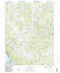 1994 Chester1998 Print · USGSMeigs County riverside and hill country are captured here in the mid-1990s as the river economy transitions. Genealogists can locate family sites at the Nease Settlement or the Welsh Town, and trace rural landmarks like Pine Grove Cem and St Johns Ch.
 - 1994 Map of Mount Alto, 1998 Print
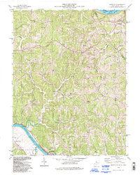 1994 Mount Alto1998 Print · USGSThe river valleys and ridge-top communities of Mason County were still deeply rural in the late twentieth century. Genealogists can trace family footprints across landmarks like Beech Hill, Mt Moriah Ch, and the remote Bearwallow Sch.
End of results
Showing maps 1-4 of 4
Top cities of Mason County
- Point Pleasant historical maps
- New Haven historical maps
- Mason historical maps
- Hartford City historical maps
- Henderson historical maps
- Leon historical maps
Frequently asked questions
- What are the different types of historical maps available for Mason County?
- What is the oldest map of Mason County?
- Where can I purchase historical maps of Mason County for my home or office?
- Where can I download high-res historical maps of Mason County?
- Are there historical topographic maps available for Mason County?
- Is there historical aerial imagery available for Mason County?
- Where are historical maps of Mason County sourced from?