Old Maps of Tucker County, West Virginia for Metal Detecting
Plan your next treasure hunt with 84 historic maps of Tucker County. Find old homesites, ghost towns, trails, and gathering spots that may be lost to time — perfect for identifying promising metal detecting locations.
- Locate forgotten sites: Uncover places like long-lost settlements, abandoned rail lines, or gathering spots.
- Plan better hunts: Use map overlays combined with LiDAR or satellite views to narrow in on historically rich areas.
- Made for detectorists: Thousands of hobbyists use these maps to discover relics, coins, and hidden history.
Use these historic maps to boost your research and find new opportunities beneath the surface of Tucker County.
Tucker County, WV maps
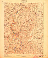
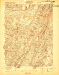
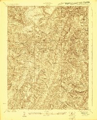
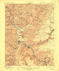
(84)- 1886 Map of St. George
 1886 St. George1886 Print · USGSNorthern West Virginia’s rugged river valleys and early rail corridors are mapped here in the mid-1880s. Genealogists can trace family roots in settlements like St George or Terra Alta, while following the path of the Baltimore and Ohio Railroad.
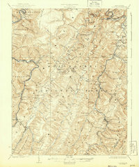
 - 1889 Map of Beverly
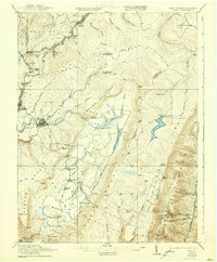
 1889 Beverly1889 Print · USGSThe high Allegheny ridges and river forks of West Virginia are mapped here in the late 1880s, highlighting the rugged settlement patterns of Randolph and Pocahontas counties. Researchers can trace early family-named locations such as Days Mills, locate the Boundary Line In Dispute, and find remote outposts like Traveller's Repose.
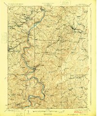
 - 1891 Map of St. George, 1895 Print
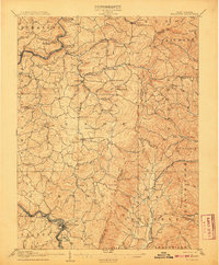
 1891 St. George1895 Print · USGSNorthern West Virginia at the end of the nineteenth century was defined by the expansion of the Baltimore and Ohio Railroad. Genealogists can trace early homesteads and landmarks like Valley Furnace, St George, and Terra Alta.3 unique versions available
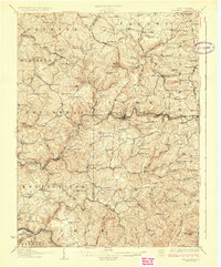
 - 1892 Map of Beverly
 1892 Beverly1892 Print · USGSCentral West Virginia's high-mountain settlements and disputed county lines are captured here in the late nineteenth century. Genealogists and historians can trace family locations and early industry near Beverly, Huttonsville, and the remote Days Mills.5 unique versions available
 - 1892 Map of Franklin
 1892 Franklin1892 Print · USGSPendleton County and the Potomac Highlands are shown here in the 1890s, organized by the dramatic ridges and river valleys of the Alleghanies. Researchers can trace historic homesteads and early post offices at Fort Seybert, Upper Tract, and the riverside crossroads of Kline Cross Roads.
 - 1895 Map of Piedmont
 1895 Piedmont1895 Print · USGSThe West Virginia and Maryland borderlands come to life in the 1890s, when coal and timber drove the expansion of the Potomac River valleys. Genealogists can trace the early industrial roots of Piedmont, locate the historic Fairfax Stone, or find the long-lost operations at Rees Tannery.4 unique versions available
 - 1896 Map of Franklin, 1907 Print
 1896 Franklin1907 Print · USGSThe Potomac River's headwaters and the high ridges of the Alleghenies are documented here in the final years of the nineteenth century. Genealogists and local historians can trace early valley communities like Fort Seybert, Sugar Grove, and the mills at Harper Mill.4 unique versions available
 - 1907 Map of Thornton
 1907 Thornton1907 Print · USGSPreston and Taylor counties are depicted here in the early years of the century as the rail industry reshaped the Appalachian highlands. Genealogists can trace family roots at specific landmarks like Summers Church, Knottsville, and Slabtown Schoolhouse along the Baltimore and Ohio RR corridor.2 unique versions available
 - 1907 Map of Kingwood
 1907 Kingwood1907 Print · USGSPreston County at the start of the twentieth century was defined by the deep gorges of the Cheat River and a network of historic turnpikes. Researchers can trace the early mountain economy through landmarks like Fairfax Ferry, the Buffalo Schoolhouse, and the Baltimore and Ohio RR corridor.2 unique versions available
 - 1907 Map of Belington
 1907 Belington1907 Print · USGSBelington was a bustling railway hub at the turn of the century where multiple rail lines met the Tygart River. Genealogists can locate family homesteads near landmarks like Olive Hill Schoolhouse, Wilmoth Ford, and the old Turnpike.2 unique versions available
 - 1908 Map of Parsons
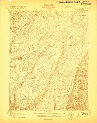
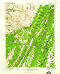
 1908 Parsons1908 Print · USGSThe West Virginia high country comes to life in this early century survey of the Parsons area. Genealogists and historians can trace the early rail networks of the W M R R and LUMBER R R connecting settlements like Thomas and St George.
 - 1916 Map of Davis
 1916 Davis1916 Print · USGSHigh in the Allegheny plateau during the mid-teens, this area centers on the bustling timber and rail hubs of Thomas and Davis. Researchers can trace the path of the Lumber RR and locate rural neighborhood centers like Maple Grove School and Cortland School.2 unique versions available
 - 1918 Map of Davis
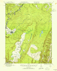
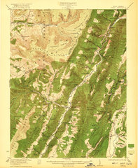
 1918 Davis1918 Print · USGSTucker County's high mountain plateaus and timber industry are at their peak during the First World War. Genealogists and historians can trace the early development of Davis and Thomas alongside rural landmarks like Maple Grove School and the Fairfax Stone.
 - 1919 Map of Davis, 1955 Print
 1919 Davis1955 Print · USGSThe West Virginia and Maryland borderlands are captured here during a peak era of timber and rail expansion. Genealogists can trace family roots through rural landmarks like the Fairfax Stone, the village of Cortland, and the Maple Grove School.2 unique versions available
 - 1920 Map of Davis
 1920 Davis1920 Print · USGSWest Virginia's high mountain plateaus and the Maryland border are captured here just after the Great War. Genealogists can trace family footprints near the Fairfax Stone or locate rural landmarks like Rohrbaugh School and the Stony River Dam.
 - 1920 Map of Onego, 1959 Print
 1920 Onego1959 Print · USGSPendleton and Grant counties in the early twentieth century are shown here as a landscape of isolated mountain communities and riverside hamlets. Researchers can trace family-named landmarks and long-standing institutions like the Germany Settlement, Mouth of Seneca, and the Evergreen Church.2 unique versions available
 - 1921 Map of Onego
 1921 Onego1921 Print · USGSThe West Virginia highlands in the early 1920s reveal a network of isolated mountain schools and valley settlements. Genealogists can trace family roots through landmarks like Onego, High Rock Church, and the Boggs School near Seneca Rock.2 unique versions available
 - 1921 Map of Davis, 1938 Print
 1921 Davis1938 Print · USGSThe West Virginia highlands and the Maryland border come alive in this early twentieth-century survey of the Allegheny Front. Researchers can trace the legacy of timber and coal through the Lumber RR and find local landmarks like the Fairfax Stone and Cortland School.2 unique versions available
 - 1922 Map of Onego
 1922 Onego1922 Print · USGSPendleton County's high ridges and river valleys are captured here in the early 1920s as the Monongahela National Forest was being established. Genealogists and hikers can locate old mountain homesteads, numerous remote schools like Keel Spring School, and the iconic Seneca Rock.2 unique versions available
 - 1922 Map of Horton
 1922 Horton1922 Print · USGSThe West Virginia highlands in the early twenties were a landscape of mountain timber towns and isolated valley schools. Genealogists can trace family names at Little Italy or Evenwood, and locate rural landmarks like Bethel Church and Mylius School.2 unique versions available
 - 1924 Map of Horton
 1924 Horton1924 Print · USGSRandolph and Tucker Counties were at the height of their rail-and-timber era in the early twenties. Researchers can trace family sites like Little Italy, industrial hubs at Whitmer, and rural landmarks such as Bethel Church or the Mylius School.2 unique versions available
 - 1925 Map of Kingwood
 1925 Kingwood1925 Print · USGSPreston County in the mid-twenties shows a landscape shaped by the Baltimore and Ohio Railroad and the winding Cheat River. Genealogists can locate dozens of country schools and churches, from St Josephs Church to the Washington Manor School and the Pleasant Valley Ford.3 unique versions available
 - 1926 Map of Thornton
 1926 Thornton1926 Print · USGSPreston and Taylor counties show a dense network of mountain settlements and rail corridors in the mid-1920s. Genealogists can locate family landmarks such as Slabcamp Church, the Pell School, and rail-side towns like Tunnelton or Newburg.2 unique versions available
 - 1926 Map of Parsons
 1926 Parsons1926 Print · USGSTucker County's industrial valleys and remote mountain ridges come alive in the mid-1920s as the rail-and-river economy boomed. Genealogists and historians can trace the foundations of local life through community hubs like Parsons, Thomas, and numerous rural sites like Macedonia Church and Fairview School.2 unique versions available
 - 1927 Map of Belington
 1927 Belington1927 Print · USGSNorth Central West Virginia is documented here in the late twenties as a network of ridge-top schools and river-bottom rail hubs. Genealogists can trace family landmarks and local institutions like Vannoy's Mill, Valley Furnace, and Moatsville Sta.2 unique versions available
Showing maps 1-25 of 84
Top cities of Tucker County
- Parsons historical maps
- Davis historical maps
- Thomas historical maps
- Hendricks historical maps
- Hambleton historical maps
Frequently asked questions
- What are the different types of historical maps available for Tucker County?
- What is the oldest map of Tucker County?
- Where can I purchase historical maps of Tucker County for my home or office?
- Where can I download high-res historical maps of Tucker County?
- Are there historical topographic maps available for Tucker County?
- Is there historical aerial imagery available for Tucker County?
- Where are historical maps of Tucker County sourced from?