1990s Maps of Tucker County, West Virginia
Explore 15 historic maps of Tucker County from the 1990s. These maps offer a rare glimpse into what life looked like during the 1990s — showing old roads, neighborhoods, homes, and landmarks that have changed or disappeared over time.
Whether you're researching your family's past, planning a metal detecting trip, or studying how Tucker County's landscape evolved across the 1990s, these high-resolution maps are a powerful tool for exploring the history of this region.
- Focus on a specific era: All maps on this page are from the 1990s, giving you a focused view of this time period.
- See what’s changed: Compare century-old streets, trails, and buildings to today's modern landscape using overlays and satellite layers.
- Research with precision: Use these maps for genealogy, historical research, land use analysis, or educational projects.
- View, download, or print: Maps are fully viewable online in high resolution, and can be downloaded or printed for your own records.
Start exploring Tucker County's history through authentic maps from the 1990s. This is your window into the past.
Tucker County, WV maps
(15)- 1995 Map of Davis, 1998 Print
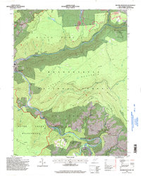
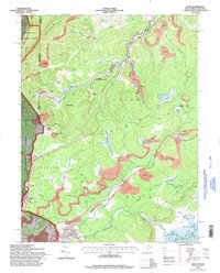 1995 Davis1998 Print · USGSThe West Virginia highlands in the mid-nineties reveal a landscape shaped by coal and timber along the Blackwater River. Trace family history at Thomas Cem or locate industrial sites like the strip mines and tipple near Henry.
 - 1995 Map of Blackwater Falls, 1998 Print
 1995 Blackwater Falls1998 Print · USGSThe West Virginia highlands in the mid-nineties reveal a landscape of vast state parks and small mountain settlements. Researchers can locate remote family cemeteries, trace the old Cheat Potomac Rd, and see the footprint of local industry at the strip mine or Quarry.2 unique versions available
 - 1995 Map of Blackbird Knob, 1998 Print
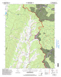
 1995 Blackbird Knob1998 Print · USGSThe West Virginia high country in the mid-1990s is captured here, showing the protected landscapes of the Dolly Sods Wilderness. Researchers can trace old paths like the Northland Loop Interpretive Trail or locate landmarks such as Blackbird Knob and Bear Rocks.
 - 1995 Map of Harman, 1998 Print
 1995 Harman1998 Print · USGSRandolph and Tucker counties in the mid-1990s show a region of high mountain ridges and river-bottom settlements. Genealogists and hikers can trace the winding Dry Fork, locate the Riverside Ch, and explore trails through the Otter Creek Wilderness.2 unique versions available
 - 1995 Map of Colebank, 1998 Print
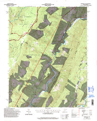
 1995 Colebank1998 Print · USGSThe high ridges of Barbour and Tucker Counties come into focus in the mid-nineties as the Monongahela National Forest meets rural valley life. Genealogists and local historians can trace family roots through landmarks like Valley Furnace, Union Chapel, and the Digman Sch.
 - 1995 Map of Lead Mine, 1998 Print
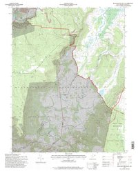
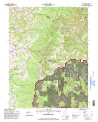
 1995 Lead Mine1998 Print · USGSTucker County and the Monongahela National Forest are shown in the mid-nineties as the industrial and natural landscapes converged. Genealogists can trace family landmarks like Sugarland Ch Cem while historians locate coal works at Coketon and Thomas.
 - 1995 Map of Saint George, 1998 Print
 1995 Saint George1998 Print · USGSTucker County in the mid-1990s remains a landscape of deep river bends and mountain ridges within the Monongahela National Forest. Researchers can trace rural life through landmarks like Saint George, the Macedonia Ch, and the riverside Camp Kidd.
 - 1995 Map of Hopeville, 1998 Print
 1995 Hopeville1998 Print · USGSThe West Virginia highlands in the mid-1990s reveal a landscape of deep river valleys and high wilderness plateaus. Researchers can trace remote mountain communities like Hopeville and Ketterman, as well as landmarks like Smoke Hole Caverns and Pleasant Valley Ch.
 - 1995 Map of Montrose, 1998 Print
 1995 Montrose1998 Print · USGSThe West Virginia highlands near Montrose are captured here in the mid-1990s as the Monongahela National Forest meets valley settlements. Genealogists and local historians can trace rural landmarks from Union Chapel to the community of Smith Crossing and the Elkins Speedway.
 - 1995 Map of Parsons, 1998 Print
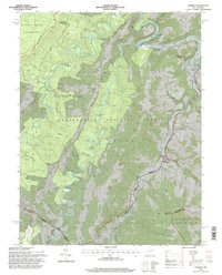
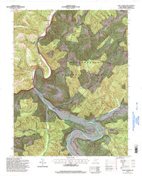
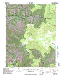
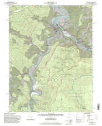 1995 Parsons1998 Print · USGSTucker County mountain life is centered on the forks of the Cheat River in the mid-nineties. Genealogists and historians can locate family-named sites like Irons Chapel, Hamrick Sch, and Collett Cem among the reaches of the Otter Creek Wilderness.2 unique versions available
 - 1995 Map of Rowlesburg, 1998 Print
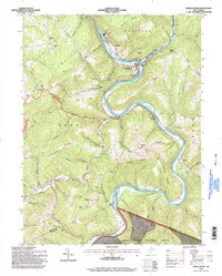 1995 Rowlesburg1998 Print · USGSRowlesburg and the Cheat River valley appear here in the late twentieth century, showing a landscape shaped by rail, timber, and coal. Genealogists can locate several family burial sites and rural landmarks like Wotring Chapel, Riverview Cem, and the Covered Bridge.2 unique versions available
 - 1995 Map of Aurora, 1998 Print
 1995 Aurora1998 Print · USGSSoutheastern Preston County communities appear at the end of the century as a blend of forest conservation and upland farming. Trace family roots at Accident Cemetery or locate old community hubs like Amboy Ch and Stemple Ridge School.2 unique versions available
 - 1995 Map of Mozark Mountain, 1998 Print
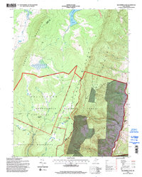
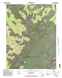
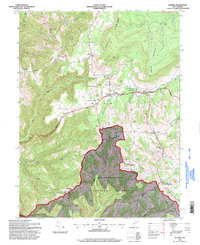
 1995 Mozark Mountain1998 Print · USGSTucker County during the mid-1990s reveals a landscape defined by the convergence of mountain forks and deep wilderness protection. Genealogists and hikers can trace the connections between the riverside settlement of Hendricks, the remote community of Gladwin, and landmarks like Brights Chapel.2 unique versions available
 - 1995 Map of Laneville, 1998 Print
 1995 Laneville1998 Print · USGSHigh Allegheny plateaus and the headwaters of Red Creek define this West Virginia mountain landscape during the mid-1990s. Researchers can locate remote sites like Flanagan Memorial Cem, the Bethel Ch, and landmarks like Thunderstruck Rock.
 - 1997 Map of Mount Storm Lake, 2001 Print
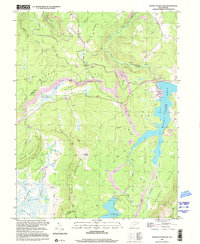 1997 Mount Storm Lake2001 Print · USGSThe West Virginia highlands are shown here in the late 1990s as a hub of energy production and mountain wilderness. Trace the industrial footprint of Mount Storm Lake alongside remote landmarks like Camp Seventy-two and Snowy Point.
End of results
Showing maps 1-15 of 15
Top cities of Tucker County
- Parsons historical maps
- Davis historical maps
- Thomas historical maps
- Hendricks historical maps
- Hambleton historical maps
Frequently asked questions
- What are the different types of historical maps available for Tucker County?
- What is the oldest map of Tucker County?
- Where can I purchase historical maps of Tucker County for my home or office?
- Where can I download high-res historical maps of Tucker County?
- Are there historical topographic maps available for Tucker County?
- Is there historical aerial imagery available for Tucker County?
- Where are historical maps of Tucker County sourced from?