1940s Maps of Tucker County, West Virginia
Explore 4 historic maps of Tucker County from the 1940s. These maps offer a rare glimpse into what life looked like during the 1940s — showing old roads, neighborhoods, homes, and landmarks that have changed or disappeared over time.
Whether you're researching your family's past, planning a metal detecting trip, or studying how Tucker County's landscape evolved across the 1940s, these high-resolution maps are a powerful tool for exploring the history of this region.
- Focus on a specific era: All maps on this page are from the 1940s, giving you a focused view of this time period.
- See what’s changed: Compare century-old streets, trails, and buildings to today's modern landscape using overlays and satellite layers.
- Research with precision: Use these maps for genealogy, historical research, land use analysis, or educational projects.
- View, download, or print: Maps are fully viewable online in high resolution, and can be downloaded or printed for your own records.
Start exploring Tucker County's history through authentic maps from the 1940s. This is your window into the past.
Tucker County, WV maps
(4)- 1941 Map of Belington
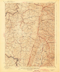 1941 Belington1941 Print · USGSBarbour and Randolph counties are shown here during the pre-war era as the Baltimore and Ohio railroad powered the local economy. Genealogists can trace family homesteads near dozens of landmarks including Vannoys Mill, Kalamazoo, and St Joseph School.
 - 1948 Map of Cumberland
 1948 Cumberland1948 Print · USGSMid-century Appalachia and the Shenandoah Valley are shown in detail, documenting the industrial and transportation hubs of the tri-state area. Genealogists can trace family roots through settlements like Double Tollgate and Bunker Hill or along the Baltimore & Ohio RR.3 unique versions available
 - 1949 Map of Kempton
 1949 Kempton1949 Print · USGSThe high plateau of the Maryland-West Virginia border comes into focus in the late 1940s, highlighting the industrial rail corridor along the Potomac River. Genealogists can trace the rural landscape around Kempton, Henry, and the historic Fairfax Stone monument.2 unique versions available
 - 1949 Map of Charlottesville
 1949 Charlottesville1949 Print · USGSThe Shenandoah Valley and Blue Ridge appear in the late 1940s as a thriving corridor of rail and river commerce. Researchers can trace the mid-century footprints of Harrisonburg, Staunton, and Culpeper alongside the historic routes of the Southern Railway.2 unique versions available
End of results
Showing maps 1-4 of 4
Top cities of Tucker County
- Parsons historical maps
- Davis historical maps
- Thomas historical maps
- Hendricks historical maps
- Hambleton historical maps
Frequently asked questions
- What are the different types of historical maps available for Tucker County?
- What is the oldest map of Tucker County?
- Where can I purchase historical maps of Tucker County for my home or office?
- Where can I download high-res historical maps of Tucker County?
- Are there historical topographic maps available for Tucker County?
- Is there historical aerial imagery available for Tucker County?
- Where are historical maps of Tucker County sourced from?