1900s (20th Century) Maps of Tucker County, West Virginia
Explore 61 historic maps of Tucker County from the 1900s (20th Century). These maps offer a rare glimpse into what life looked like during the 1900s — showing old roads, neighborhoods, homes, and landmarks that have changed or disappeared over time.
Whether you're researching your family's past, planning a metal detecting trip, or studying how Tucker County's landscape evolved across the 1900s, these high-resolution maps are a powerful tool for exploring the history of this region.
- Focus on a specific era: All maps on this page are from the 1900s, giving you a focused view of this time period.
- See what’s changed: Compare century-old streets, trails, and buildings to today's modern landscape using overlays and satellite layers.
- Research with precision: Use these maps for genealogy, historical research, land use analysis, or educational projects.
- View, download, or print: Maps are fully viewable online in high resolution, and can be downloaded or printed for your own records.
Start exploring Tucker County's history through authentic maps from the 1900s. This is your window into the past.
Tucker County, WV maps
(61)- 1907 Map of Thornton
 1907 Thornton1907 Print · USGSPreston and Taylor counties are depicted here in the early years of the century as the rail industry reshaped the Appalachian highlands. Genealogists can trace family roots at specific landmarks like Summers Church, Knottsville, and Slabtown Schoolhouse along the Baltimore and Ohio RR corridor.2 unique versions available
 - 1907 Map of Kingwood
 1907 Kingwood1907 Print · USGSPreston County at the start of the twentieth century was defined by the deep gorges of the Cheat River and a network of historic turnpikes. Researchers can trace the early mountain economy through landmarks like Fairfax Ferry, the Buffalo Schoolhouse, and the Baltimore and Ohio RR corridor.2 unique versions available
 - 1907 Map of Belington
 1907 Belington1907 Print · USGSBelington was a bustling railway hub at the turn of the century where multiple rail lines met the Tygart River. Genealogists can locate family homesteads near landmarks like Olive Hill Schoolhouse, Wilmoth Ford, and the old Turnpike.2 unique versions available
 - 1908 Map of Parsons
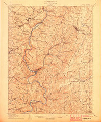
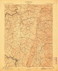
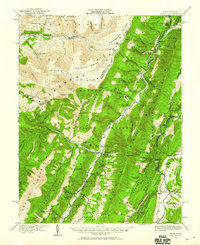
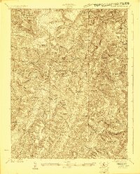
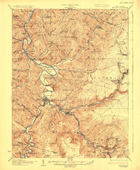
 1908 Parsons1908 Print · USGSThe West Virginia high country comes to life in this early century survey of the Parsons area. Genealogists and historians can trace the early rail networks of the W M R R and LUMBER R R connecting settlements like Thomas and St George.
 - 1916 Map of Davis
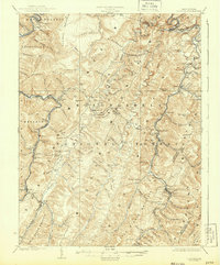
 1916 Davis1916 Print · USGSHigh in the Allegheny plateau during the mid-teens, this area centers on the bustling timber and rail hubs of Thomas and Davis. Researchers can trace the path of the Lumber RR and locate rural neighborhood centers like Maple Grove School and Cortland School.2 unique versions available
 - 1918 Map of Davis
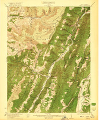
 1918 Davis1918 Print · USGSTucker County's high mountain plateaus and timber industry are at their peak during the First World War. Genealogists and historians can trace the early development of Davis and Thomas alongside rural landmarks like Maple Grove School and the Fairfax Stone.
 - 1919 Map of Davis, 1955 Print
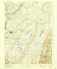
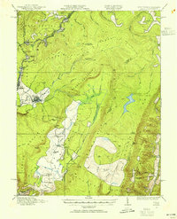 1919 Davis1955 Print · USGSThe West Virginia and Maryland borderlands are captured here during a peak era of timber and rail expansion. Genealogists can trace family roots through rural landmarks like the Fairfax Stone, the village of Cortland, and the Maple Grove School.2 unique versions available
 - 1920 Map of Davis
 1920 Davis1920 Print · USGSWest Virginia's high mountain plateaus and the Maryland border are captured here just after the Great War. Genealogists can trace family footprints near the Fairfax Stone or locate rural landmarks like Rohrbaugh School and the Stony River Dam.
 - 1920 Map of Onego, 1959 Print
 1920 Onego1959 Print · USGSPendleton and Grant counties in the early twentieth century are shown here as a landscape of isolated mountain communities and riverside hamlets. Researchers can trace family-named landmarks and long-standing institutions like the Germany Settlement, Mouth of Seneca, and the Evergreen Church.2 unique versions available
 - 1921 Map of Onego
 1921 Onego1921 Print · USGSThe West Virginia highlands in the early 1920s reveal a network of isolated mountain schools and valley settlements. Genealogists can trace family roots through landmarks like Onego, High Rock Church, and the Boggs School near Seneca Rock.2 unique versions available
 - 1921 Map of Davis, 1938 Print
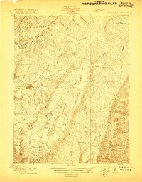
 1921 Davis1938 Print · USGSThe West Virginia highlands and the Maryland border come alive in this early twentieth-century survey of the Allegheny Front. Researchers can trace the legacy of timber and coal through the Lumber RR and find local landmarks like the Fairfax Stone and Cortland School.2 unique versions available
 - 1922 Map of Onego
 1922 Onego1922 Print · USGSPendleton County's high ridges and river valleys are captured here in the early 1920s as the Monongahela National Forest was being established. Genealogists and hikers can locate old mountain homesteads, numerous remote schools like Keel Spring School, and the iconic Seneca Rock.2 unique versions available
 - 1922 Map of Horton
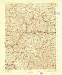
 1922 Horton1922 Print · USGSThe West Virginia highlands in the early twenties were a landscape of mountain timber towns and isolated valley schools. Genealogists can trace family names at Little Italy or Evenwood, and locate rural landmarks like Bethel Church and Mylius School.2 unique versions available
 - 1924 Map of Horton
 1924 Horton1924 Print · USGSRandolph and Tucker Counties were at the height of their rail-and-timber era in the early twenties. Researchers can trace family sites like Little Italy, industrial hubs at Whitmer, and rural landmarks such as Bethel Church or the Mylius School.2 unique versions available
 - 1925 Map of Kingwood
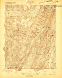
 1925 Kingwood1925 Print · USGSPreston County in the mid-twenties shows a landscape shaped by the Baltimore and Ohio Railroad and the winding Cheat River. Genealogists can locate dozens of country schools and churches, from St Josephs Church to the Washington Manor School and the Pleasant Valley Ford.3 unique versions available
 - 1926 Map of Thornton
 1926 Thornton1926 Print · USGSPreston and Taylor counties show a dense network of mountain settlements and rail corridors in the mid-1920s. Genealogists can locate family landmarks such as Slabcamp Church, the Pell School, and rail-side towns like Tunnelton or Newburg.2 unique versions available
 - 1926 Map of Parsons
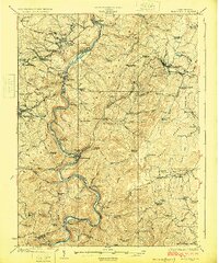
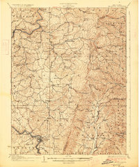
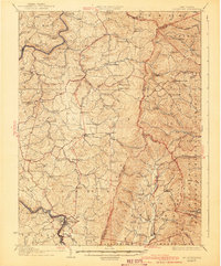
 1926 Parsons1926 Print · USGSTucker County's industrial valleys and remote mountain ridges come alive in the mid-1920s as the rail-and-river economy boomed. Genealogists and historians can trace the foundations of local life through community hubs like Parsons, Thomas, and numerous rural sites like Macedonia Church and Fairview School.2 unique versions available
 - 1927 Map of Belington
 1927 Belington1927 Print · USGSNorth Central West Virginia is documented here in the late twenties as a network of ridge-top schools and river-bottom rail hubs. Genealogists can trace family landmarks and local institutions like Vannoy's Mill, Valley Furnace, and Moatsville Sta.2 unique versions available
 - 1941 Map of Belington
 1941 Belington1941 Print · USGSBarbour and Randolph counties are shown here during the pre-war era as the Baltimore and Ohio railroad powered the local economy. Genealogists can trace family homesteads near dozens of landmarks including Vannoys Mill, Kalamazoo, and St Joseph School.
 - 1948 Map of Cumberland
 1948 Cumberland1948 Print · USGSMid-century Appalachia and the Shenandoah Valley are shown in detail, documenting the industrial and transportation hubs of the tri-state area. Genealogists can trace family roots through settlements like Double Tollgate and Bunker Hill or along the Baltimore & Ohio RR.3 unique versions available
 - 1949 Map of Kempton
 1949 Kempton1949 Print · USGSThe high plateau of the Maryland-West Virginia border comes into focus in the late 1940s, highlighting the industrial rail corridor along the Potomac River. Genealogists can trace the rural landscape around Kempton, Henry, and the historic Fairfax Stone monument.2 unique versions available
 - 1949 Map of Charlottesville
 1949 Charlottesville1949 Print · USGSThe Shenandoah Valley and Blue Ridge appear in the late 1940s as a thriving corridor of rail and river commerce. Researchers can trace the mid-century footprints of Harrisonburg, Staunton, and Culpeper alongside the historic routes of the Southern Railway.2 unique versions available
 - 1952 Map of Cumberland
 1952 Cumberland1952 Print · USGSThe Potomac Highlands and the Shenandoah Valley are revealed in this early 1950s survey of the Appalachian interior. Researchers can trace the river-and-rail corridors connecting Cumberland, Winchester, and the recreational waters of Deep Creek Lake.
 - 1956 Map of Cumberland, 1966 Print
 1956 Cumberland1966 Print · USGSThe tri-state Highlands in the mid-1950s show a landscape shaped by coal, timber, and the massive presence of the Baltimore & Ohio RR. Researchers can trace the industrial corridor from Cumberland through the Allegheny Mountains to mountain retreats like Deep Creek Lake.6 unique versions available
 - 1956 Map of Charlottesville, 1966 Print
 1956 Charlottesville1966 Print · USGSThe Shenandoah Valley and Blue Ridge are captured in detail during the mid-1960s as the modern interstate system began to emerge. Genealogists and historians can trace rail-connected hubs like Waynesboro or follow the river paths of the Rapidan River and Rivanna River.4 unique versions available
Showing maps 1-25 of 61
Top cities of Tucker County
- Parsons historical maps
- Davis historical maps
- Thomas historical maps
- Hendricks historical maps
- Hambleton historical maps
Frequently asked questions
- What are the different types of historical maps available for Tucker County?
- What is the oldest map of Tucker County?
- Where can I purchase historical maps of Tucker County for my home or office?
- Where can I download high-res historical maps of Tucker County?
- Are there historical topographic maps available for Tucker County?
- Is there historical aerial imagery available for Tucker County?
- Where are historical maps of Tucker County sourced from?