Old Maps of Appleton, Wisconsin
Explore 13 old maps of Appleton, spanning from 1911 to today. These high-resolution historic maps reveal how streets, neighborhoods, landmarks, and natural features evolved over time — perfect for genealogy, metal detecting, research, and local history exploration.
What you can do with these maps:
- See how Appleton changed over time: Compare historical maps to modern-day views to trace roads, homesites, rail lines & more.
- View detailed metadata: Each map includes creators, publishers, year, scale, and archive source.
- Overlay maps with satellite & LiDAR: Visualize the past alongside modern tools to explore terrain & human change.
- Trusted historical sources: Maps sourced from the USGS, Library of Congress, and other archives.
- Access maps your way: View online, download high-res files, or order prints for personal or research use.
Start exploring old maps of Appleton to uncover forgotten places, hidden landmarks, and the deep history beneath your feet.
Appleton, WI maps
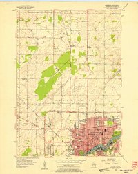
(13)- 1911 Map of Neenah, 1949 Print
 1911 Neenah1949 Print · USGSCovers Appleton, including Neenah, Grand Chute, and other nearby areas
 - 1955 Map of Neenah, 1957 Print
 1955 Neenah1957 Print · USGSCovers Appleton, including Neenah, Grand Chute, and other nearby areas3 unique versions available
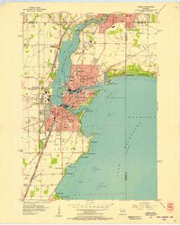
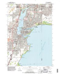
 - 1955 Map of Appleton, 1957 Print
 1955 Appleton1957 Print · USGSCovers Appleton, including Grand Chute, Mackville, and other nearby areas3 unique versions available
 - 1955 Map of Appleton, 1957 Print
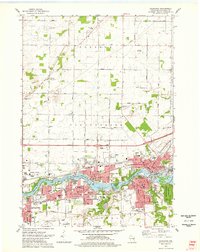
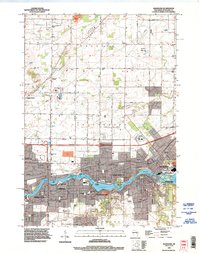
 1955 Appleton1957 Print · USGSCovers Appleton, including Grand Chute, Kaukauna, and other nearby areas2 unique versions available
 - 1955 Map of Neenah, 1957 Print
 1955 Neenah1957 Print · USGSCovers Appleton, including Neenah, Grand Chute, and other nearby areas3 unique versions available
 - 1955 Map of Green Bay, 1968 Print
 1955 Green Bay1968 Print · USGSCovers Appleton, including Green Bay, Oshkosh, and other nearby areas2 unique versions available
 - 1974 Map of Kaukauna, 1978 Print
 1974 Kaukauna1978 Print · USGSCovers Appleton, including Grand Chute, Kaukauna, and other nearby areas2 unique versions available
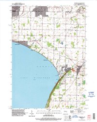
 - 1974 Map of Sherwood, 1978 Print
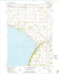 1974 Sherwood1978 Print · USGSCovers Appleton, including Menasha, Kaukauna, and other nearby areas2 unique versions available
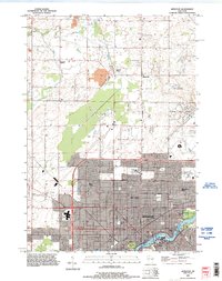
 - 1984 Map of Appleton, 1985 Print
 1984 Appleton1985 Print · USGSCovers Appleton, including Green Bay, Oshkosh, and other nearby areas2 unique versions available
 - 1992 Map of Neenah, 1996 Print
 1992 Neenah1996 Print · USGSCovers Appleton, including Neenah, Grand Chute, and other nearby areas
 - 1992 Map of Kaukauna, 1996 Print
 1992 Kaukauna1996 Print · USGSCovers Appleton, including Grand Chute, Kaukauna, and other nearby areas
 - 1992 Map of Sherwood, 1996 Print
 1992 Sherwood1996 Print · USGSCovers Appleton, including Menasha, Kaukauna, and other nearby areas
 - 1992 Map of Appleton, 1996 Print
 1992 Appleton1996 Print · USGSCovers Appleton, including Grand Chute, Mackville, and other nearby areas
End of results
Showing maps 1-13 of 13
Top cities near Appleton
- Oshkosh historical maps
- Neenah historical maps
- Grand Chute historical maps
- Fox Crossing historical maps
- Menasha historical maps
- Kaukauna historical maps
See more
Top neighborhoods of Appleton
- Apple Creek historical maps
- Huntley Houses historical maps
- Erb Park historical maps
- Old Third Ward historical maps
- Peabody Park historical maps
- River Drive historical maps
See more
Frequently asked questions
- What are the different types of historical maps available for Appleton?
- What is the oldest map of Appleton?
- Where can I purchase historical maps of Appleton for my home or office?
- Where can I download high-res historical maps of Appleton?
- Are there historical topographic maps available for Appleton?
- Is there historical aerial imagery available for Appleton?
- Where are historical maps of Appleton sourced from?