1950s Maps of Clark County, Wisconsin
Explore 14 historic maps of Clark County from the 1950s. These maps offer a rare glimpse into what life looked like during the 1950s — showing old roads, neighborhoods, homes, and landmarks that have changed or disappeared over time.
Whether you're researching your family's past, planning a metal detecting trip, or studying how Clark County's landscape evolved across the 1950s, these high-resolution maps are a powerful tool for exploring the history of this region.
- Focus on a specific era: All maps on this page are from the 1950s, giving you a focused view of this time period.
- See what’s changed: Compare century-old streets, trails, and buildings to today's modern landscape using overlays and satellite layers.
- Research with precision: Use these maps for genealogy, historical research, land use analysis, or educational projects.
- View, download, or print: Maps are fully viewable online in high resolution, and can be downloaded or printed for your own records.
Start exploring Clark County's history through authentic maps from the 1950s. This is your window into the past.
Clark County, WI maps
(14)- 1951 Map of Lublin, 1953 Print
 1951 Lublin1953 Print · USGSTaylor County agriculture meets the northern timberlands in the early fifties, centering on the rail hub of Lublin. Genealogists and historians can locate vanished rural schoolhouses like Redville Sch and trace the original paths of the MINNEAPOLIS ST PAUL AND SAULT STE MARIE railroad.
 - 1951 Map of Medford, 1954 Print
 1951 Medford1954 Print · USGSMedford and the surrounding Taylor County townships are captured here in the early fifties, showing a landscape defined by dairy farming and rail transport. Genealogists can locate numerous country schoolhouses like Thielke Sch and rural burial grounds including Little Black Cem.
 - 1951 Map of Gilman, 1969 Print
 1951 Gilman1969 Print · USGSTaylor and Clark counties are captured here in the early fifties, showing a rural landscape defined by the Yellow River and the Soo Line railroad. Genealogists can locate numerous landmarks including the Russian Ch, Meadowbrook Cem, and the Sunnyview Sch.
 - 1952 Map of Stanley, 1954 Print
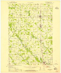
 1952 Stanley1954 Print · USGSStanley and Thorp anchor this central Wisconsin landscape in the early fifties as the rural schoolhouse system reaches its peak. Genealogists can locate family names at the Evergreen Cem or trace rural education at Busy Bee Sch and Sol Mohr Sch.
 - 1953 Map of Neillsville, 1955 Print
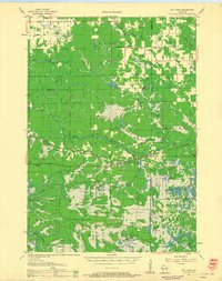
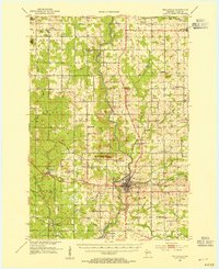 1953 Neillsville1955 Print · USGSMid-century Clark County comes into focus as a landscape of rural school districts and evolving rail corridors. Genealogists and historians can trace family locations through sites like Willard National Cemetery, York Center Ch, and over a dozen country schools including Ortole Hill Sch.2 unique versions available
 - 1953 Map of Abbotsford, 1955 Print
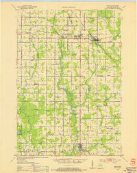
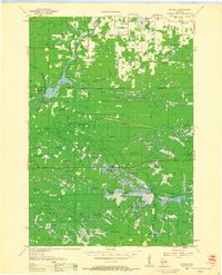
 1953 Abbotsford1955 Print · USGSCentral Wisconsin dairy country in the early fifties reveals a landscape tightly organized around the rail line and township sections. Genealogists can trace family roots through numerous local landmarks like Riplinger, St Johannis Ch, and Pickard Sch.
 - 1953 Map of Owen, 1955 Print
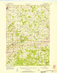
 1953 Owen1955 Print · USGSCentral Wisconsin farmland and river valleys are captured here in the early fifties, showing the peak of the rural school and church network. Researchers can trace family roots through numerous sites like Riverside Cemetery, Hoard Center Sch, and the West Beaver Church.
 - 1953 Map of Eau Claire, 1965 Print
 1953 Eau Claire1965 Print · USGSWest-central Wisconsin in the mid-fifties shows a landscape of river-valley industry and vast wildlife refuges during the transition from rails to modern highways. Genealogists and historians can trace the rail corridors of the Chicago and North Western or locate family-named landmarks like Decorah Mound and Chippewa Island.4 unique versions available
 - 1953 Map of Rice Lake, 1967 Print
 1953 Rice Lake1967 Print · USGSNorthwest Wisconsin during the mid-fifties reveals a landscape defined by timber, rail, and water. Genealogists and historians can trace the development of river towns like Ladysmith and Rice Lake along the Soo Line and Chicago and North Western railroads.2 unique versions available
 - 1954 Map of Granton, 1956 Print
 1954 Granton1956 Print · USGSCentral Wisconsin's farming heartland and rural school network are preserved here during the mid-1950s. Genealogists can locate family-named landmarks and institutions like Spokeville Sch, Grace Ch, and the high ground of Lindsey Bluffs.2 unique versions available
 - 1957 Map of City Point, 1960 Print
 1957 City Point1960 Print · USGSJackson and Clark Counties are shown here in the late fifties, dominated by the timber and cranberry industries of the Central Wisconsin Sand County. Genealogists and historians can locate rural landmarks like Audubon Sch, Martyrs Cem, and the old rail siding at Spaulding.2 unique versions available
 - 1958 Map of Eau Claire
 1958 Eau Claire1958 Print · USGSWestern Wisconsin in the late fifties shows a landscape of growing regional hubs and massive wildlife refuges. Trace the rail lines of the Chicago and North Western between Eau Claire and Marshfield, or explore the terrain around Iron Mound and Lake Wissota.
 - 1958 Map of Hatfield, 1960 Print
 1958 Hatfield1960 Print · USGSIn the late fifties, the central Wisconsin lake country was defined by its vast flowage systems and timbered mounds. Researchers can trace rural school locations like Carlyle Sch and explore old transport routes through Komensky Station or along an old railroad grade.
 - 1959 Map of Rice Lake
 1959 Rice Lake1959 Print · USGSNorthwest Wisconsin in the late fifties was a land of expanding road networks and deep-seated timber history. Genealogists and historians can trace rail lines like the Soo Line RR and Chicago St Paul Minneapolis and Omaha Ry as they link settlements from Spooner to Medford.
End of results
Showing maps 1-14 of 14
Top cities of Clark County
- Neillsville historical maps
- Thorp historical maps
- Loyal historical maps
- Greenwood historical maps
- Owen historical maps
- Dorchester historical maps
See more
Frequently asked questions
- What are the different types of historical maps available for Clark County?
- What is the oldest map of Clark County?
- Where can I purchase historical maps of Clark County for my home or office?
- Where can I download high-res historical maps of Clark County?
- Are there historical topographic maps available for Clark County?
- Is there historical aerial imagery available for Clark County?
- Where are historical maps of Clark County sourced from?