1980s Maps of Columbia County, Wisconsin
Explore 17 historic maps of Columbia County from the 1980s. These maps offer a rare glimpse into what life looked like during the 1980s — showing old roads, neighborhoods, homes, and landmarks that have changed or disappeared over time.
Whether you're researching your family's past, planning a metal detecting trip, or studying how Columbia County's landscape evolved across the 1980s, these high-resolution maps are a powerful tool for exploring the history of this region.
- Focus on a specific era: All maps on this page are from the 1980s, giving you a focused view of this time period.
- See what’s changed: Compare century-old streets, trails, and buildings to today's modern landscape using overlays and satellite layers.
- Research with precision: Use these maps for genealogy, historical research, land use analysis, or educational projects.
- View, download, or print: Maps are fully viewable online in high resolution, and can be downloaded or printed for your own records.
Start exploring Columbia County's history through authentic maps from the 1980s. This is your window into the past.
Columbia County, WI maps
(17)- 1980 Map of North Bristol
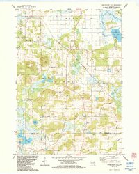
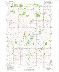 1980 North Bristol1980 Print · USGSThe agricultural heartland of Columbia and Dane Counties is captured here in the late 1970s. Local researchers can trace family lands and rural landmarks like Hampden Cemetery, the Hampden School, and the winding Crawfish River.
 - 1980 Map of Columbus, 1981 Print
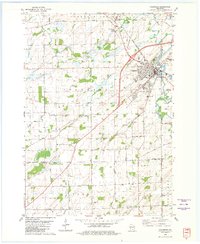 1980 Columbus1981 Print · USGSColumbus and the surrounding townships thrive along the Crawfish River during the early 1980s, where rail and river define the landscape. Local historians can trace family-named roads and rural sites like North York Cem, Townhall, and the Wisconsin Academy.
 - 1980 Map of Manchester, 1981 Print
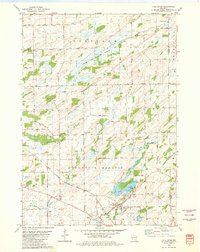
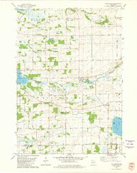 1980 Manchester1981 Print · USGSGreen Lake and Marquette counties are captured here in the early eighties, showing a landscape of river-fed lakes and established farmsteads. Genealogists can trace local roots at Phelps Cem or Williams Cem, while following the Old Indian Treaty Boundary and historic Grand River crossings.
 - 1980 Map of Rio, 1981 Print
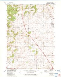
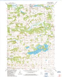
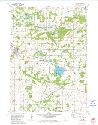 1980 Rio1981 Print · USGSColumbia County is shown in the early 1980s as a vital intersection of rail transport and wildlife conservation. Genealogists and local historians can trace family locations near Rio and Doylestown, or locate landmarks like the Bonnett Prairie Cemetery and St. Joseph Cemetery.
 - 1980 Map of Fall River, 1981 Print
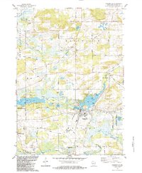
 1980 Fall River1981 Print · USGSFall River and the surrounding Columbia County wetlands appear in this 1980s-era survey during a time of steady agricultural and rail activity. Trace local family history and rural development through landmarks like St Stephen Cem, Courtland Ch, and the Milwaukee Road rail line.
 - 1980 Map of Randolph, 1981 Print
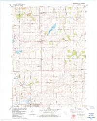
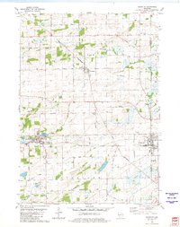 1980 Randolph1981 Print · USGSDodge and Columbia Counties at the start of the eighties show a landscape of thriving agricultural villages and critical rail junctions. Genealogists can locate family landmarks like Blaen Y Cae Cem or trace rural farm-to-market routes like Friesland Road and Vaughn Road.
 - 1980 Map of Marquette, 1981 Print
 1980 Marquette1981 Print · USGSGreen Lake County at the start of the eighties shows a landscape of expansive wetlands and small railway villages. Genealogists can trace family names and local landmarks like Grand View Cem, the Salem Ch, and the Chicago and North Western rail line.
 - 1980 Map of Sand Spring Creek, 1981 Print
 1980 Sand Spring Creek1981 Print · USGSColumbia County’s rural townships are shown in the early 1980s as the landscape transitions from the Fox River marshes to productive farmland. Genealogists and local historians can trace family road names and locate the Portage Prairie Cem or the Rosedale Ch along the Chicago Milwaukee St Paul and Pacific line.
 - 1984 Map of Arlington
 1984 Arlington1984 Print · USGSThe Wisconsin prairie at the border of Columbia and Dane Counties was a thriving rail and agricultural hub in the 1980s. Local researchers can trace family roots at Arlington Prairie Cem and 100 Mile Grove Cem or follow the historic Chicago and North Western rail line.
 - 1984 Map of Portage
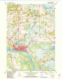 1984 Portage1984 Print · USGSPortage thrived as a vital river junction in the 1980s, where a historic Canal and lock connected the state's major waterways. Genealogists can locate several burial grounds including Old Fort Winnebago Cem and trace the Old Indian Treaty Boundary.2 unique versions available
 - 1984 Map of Poynette
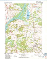 1984 Poynette1984 Print · USGSColumbia County in the mid-1980s shows a landscape of river bluffs and utility infrastructure along the winding Wisconsin River. Genealogists and local historians can locate old rural landmarks like Inch Ch, Schofield Cem, and the sprawling Poynette State Game Farm.2 unique versions available
 - 1984 Map of Endeavor
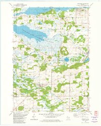
 1984 Endeavor1984 Print · USGSThe riverine corridor of Marquette County is documented here in the mid-1980s as it transitions from the village of Endeavor into expansive wetlands. Genealogists and local historians can trace family sites at the Moundville Ch, Rood Cem, and the shores of Ennis Lake.
 - 1984 Map of Observatory Hill
 1984 Observatory Hill1984 Print · USGSMarquette and Columbia counties are captured here in the mid-1980s, where rural township life meets significant wildlife conservation lands. Researchers can trace historical footprints along the Indian Treaty Boundary or locate family sites like Log Cabin Sch and Oak Lawn Cem.
 - 1984 Map of Wyocena
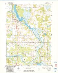
 1984 Wyocena1984 Print · USGSThe village of Wyocena and the surrounding Columbia County wetlands are captured here in the mid-1980s. Local researchers can trace family landmarks like Rocky Run Cem, the Poynette State Game Farm, and the path of the Milwaukee St Paul and Pacific railroad.
 - 1984 Map of Morrisonville
 1984 Morrisonville1984 Print · USGSColumbia and Dane counties come into focus in the mid-1980s, showcasing a landscape of established rail lines and agricultural hamlets. Genealogists can trace family roots at North Windsor Church or locate ancestral plots at Greenwood Cemetery and Zion Cemetery.
 - 1984 Map of Pardeeville
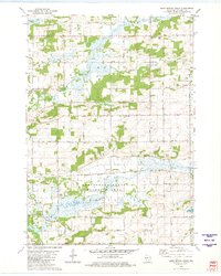
 1984 Pardeeville1984 Print · USGSMid-century Columbia County reveals a landscape shaped by glacial waters and early Wisconsin history. Genealogists and local historians can trace family roots at Comstock Cemetery, locate the Marcellon School, or follow the historic INDIAN TREATY BOUNDARY.
 - 1985 Map of Wisconsin Dells
 1985 Wisconsin Dells1985 Print · USGSCentral Wisconsin in the mid-eighties was a landscape of intricate river bends, rail junctions, and sprawling marshlands. Researchers can trace historic routes along the Soo Line or locate family landmarks near Lyndon Station, Buffalo Lake, and Puckaway Lake.
End of results
Showing maps 1-17 of 17
Top cities of Columbia County
- Portage historical maps
- Columbus historical maps
- Lodi historical maps
- Poynette historical maps
- Dekorra historical maps
- Pardeeville historical maps
See more
Frequently asked questions
- What are the different types of historical maps available for Columbia County?
- What is the oldest map of Columbia County?
- Where can I purchase historical maps of Columbia County for my home or office?
- Where can I download high-res historical maps of Columbia County?
- Are there historical topographic maps available for Columbia County?
- Is there historical aerial imagery available for Columbia County?
- Where are historical maps of Columbia County sourced from?